Concept explainers
Videos
You have seen that Earth’s terrestrial biomes reflect regional variations in climate. But what determines these climatic variations? Interpret the following diagrams in reference to how each represents effects on global patterns of temperature, rainfall, and winds.
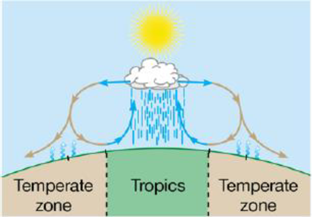
a. Solar radiation and latitude:
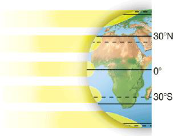
b. Earth’s orbit around the sun:
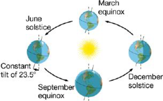
c. Global patterns of air circulation and rainfall:
(a)
To determine: Solar radiation and latitude representing the effects on global pattern of temperature, rainfall and wind and also the climatic variations.
Introduction:
Biomes are the regions with similar climate and terrestrial biome distribution is decided by rainfall and temperature. The terrestrial biomes are tundra, rainforest, desert, taiga, temperate forest, alpine and savanna.
Explanation of Solution
The solar radiation amount received by earth is depends upon the location of the biome. The amount of received sunlight will be high if the biome is located at equator, resulting in hot conditions in biome. At the poles, biomes are cold due to the availability of less sunlight.
(b)
To determine: Earth’s orbit around the sun representing the effects on global pattern of temperature, rainfall and wind and also the climatic variations.
Introduction:
Biomes are the regions with similar climate and terrestrial biome distribution is decided by rainfall and temperature. The terrestrial biomes are tundra, rainforest, desert, taiga, temperate forest, alpine and savanna.
Explanation of Solution
Different seasons are the result of earth rotation, because both hemisphere experience opposite season due to tilt of earth on its own axis.
The tilt of the northern hemisphere of earth towards the sun results in summer as the tilt allows entry of more sunlight and summer in the northern hemisphere means winter in the southern hemisphere because it is away from the sun so receives less sunlight.
(c)
To determine: Global pattern of air circulation and rainfall representing the effects on global pattern of temperature, rainfall and wind and also the climatic variations.
Introduction:
Biomes are the regions with similar climate and terrestrial biome distribution is decided by rainfall and temperature. The terrestrial biomes are tundra, rainforest, desert, taiga, temperate forest, alpine and savanna.
Explanation of Solution
Extreme sunlight at equators results in evaporation of water from the land and oceans, which cools and condenses, converting into rain. For example: tropical rainforests.
At 30 degree latitude of south and north, the circulating air warms as it fals causing evaporation of moisture present in the soil, leading to dryness (arid regions in the temperate zones). For example: deserts.
Want to see more full solutions like this?
Chapter 34 Solutions
Campbell Biology: Concepts & Connections, Books a la Carte Plus Mastering Biology with eText -- Access Card Package (8th Edition)


- 30) A B CDEFG Refer to the accompanying figure. Which of the following forms a monophyletic group? A) A, B, C, and D B) C and D C) D, E, and F D) E, F, and Garrow_forwardMolecular Biology Question. Please help with step solution and explanation. Thank you: The Polymerase Chain Reaction (PCR) reaction consists of three steps denaturation, hybridization, and elongation. Please describe what occurs in the annealing step of the PCR reaction. (I think annealing step is hybridization). What are the other two steps of PCR, and what are their functions? Next, suppose the Tm for the two primers being used are 54C for Primer A and 67C for Primer B. Regarding annealing step temperature, I have the following choices for the temperature used during the annealing step:(a) 43C (b) 49C (c) 62C (d) 73C Which temperature/temperatures should I choose? What is the corresponding correct explanation, and why would I not use the other temperatures? Have a good day!arrow_forwardUsing the data provided on the mean body mass and horn size of 4-year-old male sheep, draw a scatterplot graph to examine how body mass and horn size changed over time.arrow_forward
- Please write a 500-word report about the intake of saturated fat, sodium, alcoholic beverages, or added sugar in America. Choose ONE of these and write about what is recommended by the Dietary Guidelines for Americans (guideline #4) and why Americans exceed the intake of that nutrient. Explain what we could do as a society and/or individuals to reduce our intake of your chosen nutrient.arrow_forwardWrite a 500-word report indicating how you can change the quantity or quality of TWO nutrients where your intake was LOWER than what is recommended by the Dietary Guidelines for Americans and/or the DRIs. Indicate how the lack of the nutrient may affect your health. For full credit, all of the following points must be addressed and elaborated on in more detail for each nutrient: The name of the nutrient At least 2 main functions of the nutrient (example: “Vitamin D regulates calcium levels in the blood and calcification of bones.”) Your percent intake compared to the RDA/DRI (example “I consumed 50% of the RDA for vitamin D”) Indicate why your intake was below the recommendations (example: “I only had one serving of dairy products and that was why I was below the recommendations for vitamin D”) How would you change your dietary pattern to meet the recommendations? – be sure to list specific foods (example: “I would add a yogurt and a glass of milk to each day in order to increase my…arrow_forwardWhy are nutrient absorption and dosage levels important when taking multivitamins and vitamin and mineral supplements?arrow_forward
- I'm struggling with this topic and would really appreciate your help. I need to hand-draw a diagram and explain the process of sexual differentiation in humans, including structures, hormones, enzymes, and other details. Could you also make sure to include these terms in the explanation? . Gonads . Wolffian ducts • Müllerian ducts . ⚫ Testes . Testosterone • Anti-Müllerian Hormone (AMH) . Epididymis • Vas deferens ⚫ Seminal vesicles ⚫ 5-alpha reductase ⚫ DHT - Penis . Scrotum . Ovaries • Uterus ⚫ Fallopian tubes - Vagina - Clitoris . Labia Thank you so much for your help!arrow_forwardRequisition Exercise A phlebotomist goes to a patient’s room with the following requisition. Hometown Hospital USA 125 Goodcare Avenue Small Town, USAarrow_forwardI’m struggling with this topic and would really appreciate your help. I need to hand-draw a diagram and explain the process of sexual differentiation in humans, including structures, hormones, enzymes, and other details. Could you also make sure to include these terms in the explanation? • Gonads • Wolffian ducts • Müllerian ducts • Testes • Testosterone • Anti-Müllerian Hormone (AMH) • Epididymis • Vas deferens • Seminal vesicles • 5-alpha reductase • DHT • Penis • Scrotum • Ovaries • Uterus • Fallopian tubes • Vagina • Clitoris • Labia Thank you so much for your help!arrow_forward
- I’m struggling with this topic and would really appreciate your help. I need to hand-draw a diagram and explain the process of sexual differentiation in humans, including structures, hormones, enzymes, and other details. Could you also make sure to include these terms in the explanation? • Gonads • Wolffian ducts • Müllerian ducts • Testes • Testosterone • Anti-Müllerian Hormone (AMH) • Epididymis • Vas deferens • Seminal vesicles • 5-alpha reductase • DHT • Penis • Scrotum • Ovaries • Uterus • Fallopian tubes • Vagina • Clitoris • Labia Thank you so much for your help!arrow_forwardOlder adults have unique challenges in terms of their nutrient needs and physiological changes. Some changes may make it difficult to consume a healthful diet, so it is important to identify strategies to help overcome these obstacles. From the list below, choose all the correct statements about changes in older adults. Select all that apply. Poor vision can make it difficult for older adults to get to a supermarket, and to prepare meals. With age, taste and visual perception decline. As people age, salivary production increases. In older adults with dysphagia, foods like creamy soups, applesauce, and yogurt are usually well tolerated. Lean body mass increases in older adults.arrow_forwardWhen physical activity increases, energy requirements increase also. Depending on the type, intensity, and duration of physical activity, the body’s requirements for certain macronutrients may change as well. From the list below, choose all the correct statements about the effects of increased physical activity or athletic training. Select all that apply. An athlete who weighs 70 kg (154 lb) should consume 420 to 700 g of carbohydrate per day. How much additional energy an athlete needs depends on the specific activity the athlete engages in and the frequency of the activity. Those participating in vigorous exercise should restrict their fat intake to less than 15%% of total energy intake. Athletes who are following energy-restricted diets are at risk for consuming insufficient protein. The recommendation to limit saturated fat intake to less than 10%% of total energy intake does not apply to athletes or those who regularly engage in vigorous physical activity.arrow_forward
 Biology (MindTap Course List)BiologyISBN:9781337392938Author:Eldra Solomon, Charles Martin, Diana W. Martin, Linda R. BergPublisher:Cengage Learning
 Concepts of BiologyBiologyISBN:9781938168116Author:Samantha Fowler, Rebecca Roush, James WisePublisher:OpenStax College
 Biology: The Dynamic Science (MindTap Course List)BiologyISBN:9781305389892Author:Peter J. Russell, Paul E. Hertz, Beverly McMillanPublisher:Cengage Learning
 Human Biology (MindTap Course List)BiologyISBN:9781305112100Author:Cecie Starr, Beverly McMillanPublisher:Cengage Learning
 Biology 2eBiologyISBN:9781947172517Author:Matthew Douglas, Jung Choi, Mary Ann ClarkPublisher:OpenStax