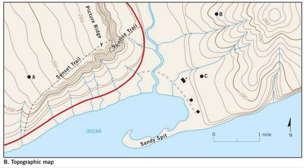
Determine the contour interval used on this map
Contour interval:_________________ feet.
![]()


The counter interval used on the given topographic map of a hypothetical area.
Introduction:
Topographic maps represent large scale structures of the Earth surface such as hills, streams, and valley. The contour interval is defined as the difference in the vertical elevation between the adjacent contour lines.
Explanation of Solution
Contour interval is calculated by the given formula:
The difference in elevation from the given map is calculated as:
Number of contour lines are 5
Therefore, by substituting the following values in equation (I),
Hence, the counter interval used on the given map is 20 feet.
Want to see more full solutions like this?
Chapter 7 Solutions
Applications and Investigations in Earth Science (9th Edition)
Additional Science Textbook Solutions
Brock Biology of Microorganisms (15th Edition)
Applications and Investigations in Earth Science (9th Edition)
Human Anatomy & Physiology (2nd Edition)
Campbell Essential Biology (7th Edition)
Campbell Biology (11th Edition)
Living By Chemistry: First Edition Textbook
- Suppose you are visiting the equator. It is noon. The Sun is at its highest point in the sky for the day, which is directly over your head. You call a friend on the phone, and she says it is also noon where she is but the Sun is not directly overhead at that location and time. It is a little lower in the sky for her. Compare the longitude and latitude of your location with the longitude and latitude of your friend's location. Are they alike or different? How do you know?arrow_forwardProvide examples to illustrate the effects of glacier and ice sheet melting on climate globally and regionally. Use words to illustrate any feedback mechanisms between melting ice sheets and the climate.arrow_forwardUse diagrams and word explanations to show how excess heat from the tropics is transferred to higher latitudes (discuss cells and ciruclations) . Additionally, show how the broadening of the Hadley Cell, caused by rising greenhouse gases, could affect surface climate in subtropical and mid-latitude regions.arrow_forward
- Explain why the Earth is in not in radiative equilibriumarrow_forwardShowing the energy flows into and out of Earth’s atmosphere with energy sketches. Clearly label each flow for what it represents, distinguishing between solar and terrestrial energy flows. Explain the diagrams in more detailsarrow_forward44) In periglacial environments, the layer of ground that thaws every summer and freezes every winter is called A) frost layer B) permafrost C) active layer D) discontinuous permafrostarrow_forward
- Use the attached piezometer map to make your own, clean version of the map, and indicate the elevation of the water table at all piezometer locations. Draw equipotential lines (lines of equal water table elevation) using regular intervals – creating a contoured map of the water table. Determine the direction of groundwater flow based on the horizontal gradient. Label the areas of recharge and discharge directly on your map. Flow lines: Draw flow lines on your water table map. The lines should be at right angles to the equipotential lines and extend from the recharge area to the discharge area. Hydraulic Gradient, Specific Discharge (Darcy Flux), Average Linear Velocity: Using your water table map, estimate an average hydraulic gradient between two locations, call them locations A and B, one at the eastern-most and a second at the western-most extent of your dataset (note the north arrow on the map). Calculate the specific discharge, q, between the two locations. For this calculation…arrow_forwardCalculate all the values of table 1: Q in (L/day) Q out (L/day) Residence time (days) Please show all stepsarrow_forwardCalculate all the values of table 1: Q in (L/day) Q out (L/day) Residence time (days)arrow_forward
- Calculate the values of table 1arrow_forward<task> Solve the task by identifying the type of grain found in the black-highlighted areas on the map and provide two factors influencing its distribution.</task> <instructions> <instruction>Analyze the map: First, carefully examine the highlighted areas on the map. Pay attention to the continents and regions where these areas are located. Try to identify the general climate zones in which these areas fall.</instruction> <instruction>Consider the types of grain: Think about different kinds of grains and their climatic and geographical preferences worldwide. What grains are cultivated in the highlighted regions?</instruction> <instruction>Use additional clues (if available): If you have supplementary images with various grains, compare their distribution with the map in the task. This could help narrow down the possibilities.</instruction> <instruction>Select the most likely grain: Based on the map analysis and…arrow_forward41) Alpine glaciers A) are the largest types of glaciers. B) conform to the shape of the landscape. C) cover large sections of continents. D) show no relationship with the underlying topography.arrow_forward
 Applications and Investigations in Earth Science ...Earth ScienceISBN:9780134746241Author:Edward J. Tarbuck, Frederick K. Lutgens, Dennis G. TasaPublisher:PEARSON
 Exercises for Weather & Climate (9th Edition)Earth ScienceISBN:9780134041360Author:Greg CarbonePublisher:PEARSON
 Environmental ScienceEarth ScienceISBN:9781260153125Author:William P Cunningham Prof., Mary Ann Cunningham ProfessorPublisher:McGraw-Hill Education
 Earth Science (15th Edition)Earth ScienceISBN:9780134543536Author:Edward J. Tarbuck, Frederick K. Lutgens, Dennis G. TasaPublisher:PEARSON
 Environmental Science (MindTap Course List)Earth ScienceISBN:9781337569613Author:G. Tyler Miller, Scott SpoolmanPublisher:Cengage Learning
 Physical GeologyEarth ScienceISBN:9781259916823Author:Plummer, Charles C., CARLSON, Diane H., Hammersley, LisaPublisher:Mcgraw-hill Education,


