
Applications and Investigations in Earth Science (9th Edition)
9th Edition
ISBN: 9780134746241
Author: Edward J. Tarbuck, Frederick K. Lutgens, Dennis G. Tasa
Publisher: PEARSON
expand_more
expand_more
format_list_bulleted
Textbook Question
Chapter 7.9, Problem 1A
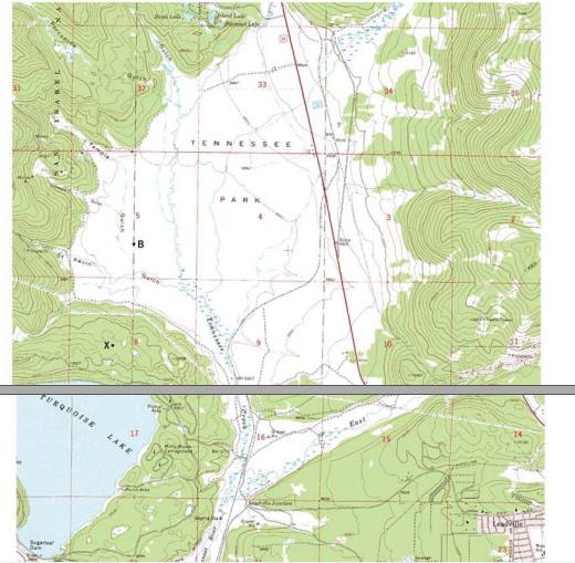
What is the contour interval of this map?
Expert Solution & Answer

Learn your wayIncludes step-by-step video

schedule03:16
Students have asked these similar questions
Please help as soon as possible. I have an answer for this, but I'm a bit confused, so any extra assistance would be appreciated!
Complete the cross sections on the front and side of the block diagram in Figure 6.6.
Complete the cross-section of the side of the block diagram in Figure 6.7.
Complete the front and side of the block diagram in Figure 6.8
a. Draw four sedimentary layers of equal thickness that have a strike of N90°E. (Hint: Sketch the map view first.)b. Each layer is dipping to the south at an angle of 60°.c. On the block diagram complete the map view and both cross-sectional views.d. Add strike-dip symbols for each rock layer on both parts of Figure 6.9.
There is an old axiom (a self-evident or universally recognized truth) of economics that “There is no such thing as a free lunch”. In the United States, stringent, enforced water quality laws and regulations provide a high level of protection of our waters. This is accomplished at a significant cost. For example, (sewage treatment plants use 2% of the electricity produced in the United States. This high level of protection increases the cost of goods manufactured in the United States compared to other nations such as China where standards are lower, enforcement a bit lax and in some cases, non-existent.
What five (5) things could be done to “level the playing field” so that all manufacturers must provide the same degree of water quality protection no matter where in the world they are located? include how each of your ideas will be implemented (ex: which organization will be provided the power and resources to make sure each idea happens). These should be only about water pollution,…
Chapter 7 Solutions
Applications and Investigations in Earth Science (9th Edition)
Ch. 7.1 - Obtain a stereoscope from your instructor, unfold...Ch. 7.1 - Prob. 2ACh. 7.1 - Prob. 3ACh. 7.1 - Prob. 4ACh. 7.2 - Prob. 1ACh. 7.2 - Prob. 2ACh. 7.3 - Prob. 1ACh. 7.3 - Prob. 3ACh. 7.3 - Prob. 6ACh. 7.4 - Depending on the map scale, 1 inch on a...
Ch. 7.4 - Examine Figure 7.6 and complete the map...Ch. 7.6 - The difference in elevation between adjacent...Ch. 7.6 - What is the difference in elevation between Points...Ch. 7.6 - Notice that every fifth contour line, called an...Ch. 7.6 - Prob. 4ACh. 7.6 - One or more roughly circular closed contours...Ch. 7.6 - Closed contours with hachures short lines that...Ch. 7.6 - When contour lines cross streams or dry stream...Ch. 7.6 - Estimating the elevations of places not located on...Ch. 7.6 - Relief is defined as the difference in elevation...Ch. 7.7 - Use the elevations in Figure 7.12 as a guide for...Ch. 7.7 - Does the land shown on the topographic map you...Ch. 7.7 - Use the profile graph in Figure 7.14 to construct...Ch. 7.8 - Use the profile graph in Figure 7.14 to construct...Ch. 7.9 - What is the contour interval of this map?Ch. 7.9 - What is the difference in elevation from one index...Ch. 7.9 - Prob. 3ACh. 7.9 - Locate the small intermittent stream blue dashed...Ch. 7.9 - What is the approximate elevation of the point...Ch. 7.9 - What is the approximate relief between point X and...Ch. 7.9 - Which of the following phrases best describes the...Ch. 7.9 - The area on both sides of Tennessee Creek in...Ch. 7.9 - Describe the change in elevation you would...Ch. 7.9 - What is the elevation of the town of Leadville,...Ch. 7.9 - Prob. 11ACh. 7 - Determine the contour interval used on this map...Ch. 7 - List the elevations of each index contour on the...Ch. 7 - What are the elevations of the locations...Ch. 7 - What is the elevation of the church? Elevation of...Ch. 7 - Indicate two areas on this map that have steep...Ch. 7 - Describe the relief of Sandy Spit with one of the...Ch. 7 - Mark the top of the hill in the northeast corner...Ch. 7 - Is the top of Picture Ridge, designated Y, at a...Ch. 7 - What is the maximum relief shown on this contour...Ch. 7 - Imagine that you are taking a group of friends...Ch. 7 - Use the satellite images in figure 7.17, which...
Additional Science Textbook Solutions
Find more solutions based on key concepts
APPLY 1.2 Express the following quantities in scientific notation
using fundamental SI units of mass and lengt...
Chemistry (7th Edition)
58. Does a real automobile have constant acceleration? Measured data for a Porsche 944 Turbo at maximum acceler...
College Physics: A Strategic Approach (3rd Edition)
The following results were obtained from a broth dilution test for microbial susceptibility. Antibiotic Concent...
Microbiology: An Introduction
4. How do gross anatomy and microscopic anatomy differ?
Human Anatomy & Physiology (2nd Edition)
Why are mutants used as test organisms in the Ames test?
Laboratory Experiments in Microbiology (12th Edition) (What's New in Microbiology)
Match the following examples of mutagens. Column A Column B ___a. A mutagen that is incorporated into DNA in pl...
Microbiology: An Introduction
Knowledge Booster

Similar questions
- Connecticut is the only state in America where treated industrial and municipal wastewater cannot be discharged to a surface water body used downstream as a source of drinking water. It is legal in all 49 other states. For example, New Orleans, Louisiana takes its drinking water from the Mississippi River which receives discharges of many, many treated municipal and industrial wastewater discharges as well as agricultural runoff from the more than 20 states that are upstream of it. Should other states be required to adopt Connecticut's standard? Whyarrow_forwardWhat is thermal pollution? How can it be controlled?arrow_forwardhow can the addition of nutrients such as nitrates and phosphates result in a reduction of the amount of dissolved oxygen in the water?arrow_forward
- Congratulations! You have just been selected to be the ruler of China with absolute power! What are the first five things that you would do to protect the environment and human health from water pollution (not other types of pollution)?arrow_forwardWhy is storm water management more of a problem in an urban area than in a rural area?arrow_forwardwhat is biochemical oxygen demand? how is it related to water quality?arrow_forward
- How are most industrial wastes disposed of? How has this changed over the past 25 years?arrow_forwardThink about natural resource management topics. Which topic or topics, are most interesting?arrow_forwardThink about natural resource management topics. Which topic or topics, if any, are of most interest to you?arrow_forward
arrow_back_ios
SEE MORE QUESTIONS
arrow_forward_ios
Recommended textbooks for you
 Applications and Investigations in Earth Science ...Earth ScienceISBN:9780134746241Author:Edward J. Tarbuck, Frederick K. Lutgens, Dennis G. TasaPublisher:PEARSON
 Exercises for Weather & Climate (9th Edition)Earth ScienceISBN:9780134041360Author:Greg CarbonePublisher:PEARSON
 Environmental ScienceEarth ScienceISBN:9781260153125Author:William P Cunningham Prof., Mary Ann Cunningham ProfessorPublisher:McGraw-Hill Education
 Earth Science (15th Edition)Earth ScienceISBN:9780134543536Author:Edward J. Tarbuck, Frederick K. Lutgens, Dennis G. TasaPublisher:PEARSON
 Environmental Science (MindTap Course List)Earth ScienceISBN:9781337569613Author:G. Tyler Miller, Scott SpoolmanPublisher:Cengage Learning
 Physical GeologyEarth ScienceISBN:9781259916823Author:Plummer, Charles C., CARLSON, Diane H., Hammersley, LisaPublisher:Mcgraw-hill Education,
Applications and Investigations in Earth Science ...
Earth Science
ISBN:9780134746241
Author:Edward J. Tarbuck, Frederick K. Lutgens, Dennis G. Tasa
Publisher:PEARSON
Exercises for Weather & Climate (9th Edition)
Earth Science
ISBN:9780134041360
Author:Greg Carbone
Publisher:PEARSON
Environmental Science
Earth Science
ISBN:9781260153125
Author:William P Cunningham Prof., Mary Ann Cunningham Professor
Publisher:McGraw-Hill Education
Earth Science (15th Edition)
Earth Science
ISBN:9780134543536
Author:Edward J. Tarbuck, Frederick K. Lutgens, Dennis G. Tasa
Publisher:PEARSON
Environmental Science (MindTap Course List)
Earth Science
ISBN:9781337569613
Author:G. Tyler Miller, Scott Spoolman
Publisher:Cengage Learning
Physical Geology
Earth Science
ISBN:9781259916823
Author:Plummer, Charles C., CARLSON, Diane H., Hammersley, Lisa
Publisher:Mcgraw-hill Education,