
Applications and Investigations in Earth Science (9th Edition)
9th Edition
ISBN: 9780134746241
Author: Edward J. Tarbuck, Frederick K. Lutgens, Dennis G. Tasa
Publisher: PEARSON
expand_more
expand_more
format_list_bulleted
Textbook Question
Chapter 7.6, Problem 6A
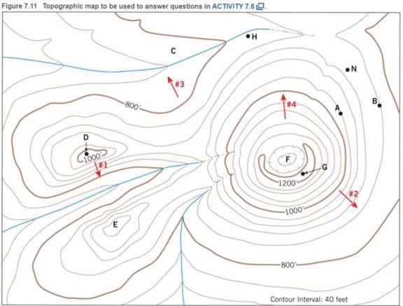
Closed contours with hachures (short lines) that point down slope indicate depressions (basins without outlets). Which of the landforms labeled D-G are depressions?
Expert Solution & Answer

Learn your wayIncludes step-by-step video

schedule09:17
Students have asked these similar questions
Draw a cross section with a tree growing out of Earth’s surface (so I know which side is the surface). Add a dipping joint and label the hanging wall and footwall blocks.
Draw a second cross section (again with a tree on the surface of the Earth) that shows how Earth’s surface would be offset along this joint if it turned into a normal fault. Label the hanging wall and footwall and use arrows to indicate the motion of the hanging wall relative to the footwall.
Now draw a third cross section with all the same elements as in parts A and B, but for a trust/reverse fault.
Imagine the same cross section either in three dimensions, or in a bird’s-eye view from top down. Draw what this area would look like after a right-lateral strike-slip fault. Label the strike of the fault and use arrows to show directions of movement
Examine the strike and dip of the rock units on the Devil's Fence geologic map in Figure 6.21. Draw multiple large arrows on the map, pointing in the direction of dip on several rock units.
Do the rock layers located near the center of the map in Section 14 dip toward the northwest or southeast?
The same rocks in Section 14 are also found in Section 18. Do the rocks in Section 18 dip toward the east or west?
What is the approximate angle of dip of the units in Section 18?
1. Draw a dashed line representing the hinge line of the large geologic structure that occupies most of the map. Label the hinge line.
2. Are the rocks getting older or younger farther from the hinge line?
3. Is this geologic structure a plunging anticline or syncline?
4. Provide two lines of evidence that support your answer to Question 8.
Chapter 7 Solutions
Applications and Investigations in Earth Science (9th Edition)
Ch. 7.1 - Obtain a stereoscope from your instructor, unfold...Ch. 7.1 - Prob. 2ACh. 7.1 - Prob. 3ACh. 7.1 - Prob. 4ACh. 7.2 - Prob. 1ACh. 7.2 - Prob. 2ACh. 7.3 - Prob. 1ACh. 7.3 - Prob. 3ACh. 7.3 - Prob. 6ACh. 7.4 - Depending on the map scale, 1 inch on a...
Ch. 7.4 - Examine Figure 7.6 and complete the map...Ch. 7.6 - The difference in elevation between adjacent...Ch. 7.6 - What is the difference in elevation between Points...Ch. 7.6 - Notice that every fifth contour line, called an...Ch. 7.6 - Prob. 4ACh. 7.6 - One or more roughly circular closed contours...Ch. 7.6 - Closed contours with hachures short lines that...Ch. 7.6 - When contour lines cross streams or dry stream...Ch. 7.6 - Estimating the elevations of places not located on...Ch. 7.6 - Relief is defined as the difference in elevation...Ch. 7.7 - Use the elevations in Figure 7.12 as a guide for...Ch. 7.7 - Does the land shown on the topographic map you...Ch. 7.7 - Use the profile graph in Figure 7.14 to construct...Ch. 7.8 - Use the profile graph in Figure 7.14 to construct...Ch. 7.9 - What is the contour interval of this map?Ch. 7.9 - What is the difference in elevation from one index...Ch. 7.9 - Prob. 3ACh. 7.9 - Locate the small intermittent stream blue dashed...Ch. 7.9 - What is the approximate elevation of the point...Ch. 7.9 - What is the approximate relief between point X and...Ch. 7.9 - Which of the following phrases best describes the...Ch. 7.9 - The area on both sides of Tennessee Creek in...Ch. 7.9 - Describe the change in elevation you would...Ch. 7.9 - What is the elevation of the town of Leadville,...Ch. 7.9 - Prob. 11ACh. 7 - Determine the contour interval used on this map...Ch. 7 - List the elevations of each index contour on the...Ch. 7 - What are the elevations of the locations...Ch. 7 - What is the elevation of the church? Elevation of...Ch. 7 - Indicate two areas on this map that have steep...Ch. 7 - Describe the relief of Sandy Spit with one of the...Ch. 7 - Mark the top of the hill in the northeast corner...Ch. 7 - Is the top of Picture Ridge, designated Y, at a...Ch. 7 - What is the maximum relief shown on this contour...Ch. 7 - Imagine that you are taking a group of friends...Ch. 7 - Use the satellite images in figure 7.17, which...
Additional Science Textbook Solutions
Find more solutions based on key concepts
Chlorine has two isotopes, 35Cl and 37Cl; 75.77% of chlorine is 35Cl, and 24.23% is 37Cl. The atomic mass of 35...
Organic Chemistry (8th Edition)
11. Birds and mammals are both endothermic, and both have four-chambered hearts. Most reptiles are ectothermic ...
Campbell Biology: Concepts & Connections (9th Edition)
Two culture media were inoculated with four different bacteria. After incubation, the following results were ob...
Microbiology: An Introduction
Modified True/False 6. __________ Halophiles inhabit extremely saline habitats, such as the Great Salt Lake.
Microbiology with Diseases by Body System (5th Edition)
17.25 You are asked to prepare a pH = 3.00 buffer solution starting from 1.25 L of a 1.00 M solution of hydrofl...
Chemistry: The Central Science (14th Edition)
A womans father has ornithine transcarbamylase deficiency (OTD), an X-linked recessive disorder producing menta...
Genetic Analysis: An Integrated Approach (3rd Edition)
Knowledge Booster

Similar questions
- On the map in Figure 6.21, write the word oldest where the oldest sedimentary rock unit is exposed at the sur-face and the word youngest where the youngest sedimentary rocks occur.arrow_forwardDiscussion Question: Glacial (or Ice) and Periglacial Landscapes A+ The Ice and Glaciers chapter focuses on the Cryosphere, the ice on our planet. I always find it interesting to consider the Earth's Hydrologic Cycle, our water in all of the different phases: solid ice, liquid water, and water vapor (a gas). In place number one for the majority of the World's water, we have the oceans. In place number two, we have ice. Neither one is available to us for drinking water at this point. Amazingly enough, in place number three is groundwater before lakes and streams. Water has led to many problems in the history of California, the United States, and even the world. Nevada Idaho B) at Flats el Mone Lake Arizona Severe Dry Lake (c) Mono Lake, tufa towersarrow_forwardDiscussion Question: River (or Stream) Systems A+ Should New Orleans have been reconstructed or not? 94 (b) 40 80 MILES Louisiana 40 80 KILOMETERS Old River Control Project Alexandria 93 Gulf of Mexico 92 Lake Pontobartrain Now Orleans Morgan City H High pressure PACIFIC OCEAN 30- General region of 150%+ precipitation during summer CP Cool, dry air Jer stream shed south Divergence mT air mass is pumped into the Midwest for weeks 400 800 MILES 400 800 KILOMETERS 120° Heal wave High pressure Stagnant air m Warm, wet unstable ATLANTIC OCEAN Tropic of Cancer 91 89 ° 110° 70°arrow_forward
- Los Angeles's demand for water exceeds the amount of water available. There are no other new sources of water available, so Los Angeles is planning on constructing the high technology facilities necessary to produce drinking water from treated municipal wastewater (i.e. "Toilet to Tap"). Public perception (i.e. the "yuch! factor"), not well established, proven technology, to accomplish this task, is going to be the big problem. Develop a five (5) item marketing plan to convince the "beautiful" people of Los Angeles that drinking water that is recycled sewage that exceeds all U.S. EPA drinking water standards. This can be done because as Slide 63 shows, doctors once were used to sell Lucky Strike cigarettes - "Your throat protection: against irritation, against cough". Cigarettes, as is now known are harmful to your health while the drinking water produced from sewage is of equal quality and in many instances higher quality than your existing drinking water.arrow_forwardRead June 17, 2023, editorial from the Wall Street Journal entitled "Biden's Fishy Plan to Breach the Snake River Dams. The editorial raises a number of concerns about the plans of the administration of President Joseph Robinette Biden to remove four hydroelectric dams from the Snake River in southeastern Washington. Your responsibility for this Exercise is to list five (5) of the concerns raised in the editorial and provide fact-based arguments (NOT YOUR PERSONAL OPINION), including references from sources other than the editorial, either supporting or disagreeing with each of the five (5) concerns.arrow_forwardShould the United States allow Mexico to have water from the Rio Grande and the Colorado River, both of which originate in the United States and flow to Mexico?arrow_forward
- What are the similarities between domestic and industrial water use? How are they different from in-stream use?arrow_forwardDo you believe that large-scale hydroelectric power plants should be promoted as a renewable alternative to power plants that burn fossil fuels? What criteria do you use for this decision?arrow_forwardDo nonfarmers have an interest in how water is used for irrigation? Under what conditions should the general public be involved in making these decisions along with the farmers who are directly involved?arrow_forward
arrow_back_ios
SEE MORE QUESTIONS
arrow_forward_ios
Recommended textbooks for you
 Applications and Investigations in Earth Science ...Earth ScienceISBN:9780134746241Author:Edward J. Tarbuck, Frederick K. Lutgens, Dennis G. TasaPublisher:PEARSON
 Exercises for Weather & Climate (9th Edition)Earth ScienceISBN:9780134041360Author:Greg CarbonePublisher:PEARSON
 Environmental ScienceEarth ScienceISBN:9781260153125Author:William P Cunningham Prof., Mary Ann Cunningham ProfessorPublisher:McGraw-Hill Education
 Earth Science (15th Edition)Earth ScienceISBN:9780134543536Author:Edward J. Tarbuck, Frederick K. Lutgens, Dennis G. TasaPublisher:PEARSON
 Environmental Science (MindTap Course List)Earth ScienceISBN:9781337569613Author:G. Tyler Miller, Scott SpoolmanPublisher:Cengage Learning
 Physical GeologyEarth ScienceISBN:9781259916823Author:Plummer, Charles C., CARLSON, Diane H., Hammersley, LisaPublisher:Mcgraw-hill Education,
Applications and Investigations in Earth Science ...
Earth Science
ISBN:9780134746241
Author:Edward J. Tarbuck, Frederick K. Lutgens, Dennis G. Tasa
Publisher:PEARSON
Exercises for Weather & Climate (9th Edition)
Earth Science
ISBN:9780134041360
Author:Greg Carbone
Publisher:PEARSON
Environmental Science
Earth Science
ISBN:9781260153125
Author:William P Cunningham Prof., Mary Ann Cunningham Professor
Publisher:McGraw-Hill Education
Earth Science (15th Edition)
Earth Science
ISBN:9780134543536
Author:Edward J. Tarbuck, Frederick K. Lutgens, Dennis G. Tasa
Publisher:PEARSON
Environmental Science (MindTap Course List)
Earth Science
ISBN:9781337569613
Author:G. Tyler Miller, Scott Spoolman
Publisher:Cengage Learning
Physical Geology
Earth Science
ISBN:9781259916823
Author:Plummer, Charles C., CARLSON, Diane H., Hammersley, Lisa
Publisher:Mcgraw-hill Education,