
Applications and Investigations in Earth Science (9th Edition)
9th Edition
ISBN: 9780134746241
Author: Edward J. Tarbuck, Frederick K. Lutgens, Dennis G. Tasa
Publisher: PEARSON
expand_more
expand_more
format_list_bulleted
Textbook Question
Chapter 7.9, Problem 4A
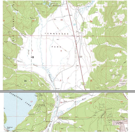
Locate the small intermittent stream (blue dashed line) just below the red number 9 that denotes Section 9. Toward what general direction does the stream now? Explain how you arrived at your answer
Expert Solution & Answer

Learn your wayIncludes step-by-step video

schedule00:59
Students have asked these similar questions
Why might drought actually cause fire risk to reduce in a desert area?
Part 1: A completely saturated sample of sandstone has a bulk density of 2.61 g/cm³, an
effective porosity of 10 percent, and a total porosity of 12 percent.
Determine the density of the solid phase (i.e., the density of the mineral).
Part 2: One cubic meter of quartz sand has a dry mass of 2,320 kg.
a) Calculate the porosity of the sand.
b) Calculate the mass (in kg) of the sand for the following degrees of saturation:
25 percent, 75 percent, 100 percent.
Part 3: A sample of quartz sand has a dry mass of 753.7 kg and a volume of 0.36 m³.
a) Calculate the porosity of the sand.
b) Calculate the mass (in kg) of the sand assuming a degree of saturation equal to
62 percent.
What is an oxbow lake and how is it formed?
Chapter 7 Solutions
Applications and Investigations in Earth Science (9th Edition)
Ch. 7.1 - Obtain a stereoscope from your instructor, unfold...Ch. 7.1 - Prob. 2ACh. 7.1 - Prob. 3ACh. 7.1 - Prob. 4ACh. 7.2 - Prob. 1ACh. 7.2 - Prob. 2ACh. 7.3 - Prob. 1ACh. 7.3 - Prob. 3ACh. 7.3 - Prob. 6ACh. 7.4 - Depending on the map scale, 1 inch on a...
Ch. 7.4 - Examine Figure 7.6 and complete the map...Ch. 7.6 - The difference in elevation between adjacent...Ch. 7.6 - What is the difference in elevation between Points...Ch. 7.6 - Notice that every fifth contour line, called an...Ch. 7.6 - Prob. 4ACh. 7.6 - One or more roughly circular closed contours...Ch. 7.6 - Closed contours with hachures short lines that...Ch. 7.6 - When contour lines cross streams or dry stream...Ch. 7.6 - Estimating the elevations of places not located on...Ch. 7.6 - Relief is defined as the difference in elevation...Ch. 7.7 - Use the elevations in Figure 7.12 as a guide for...Ch. 7.7 - Does the land shown on the topographic map you...Ch. 7.7 - Use the profile graph in Figure 7.14 to construct...Ch. 7.8 - Use the profile graph in Figure 7.14 to construct...Ch. 7.9 - What is the contour interval of this map?Ch. 7.9 - What is the difference in elevation from one index...Ch. 7.9 - Prob. 3ACh. 7.9 - Locate the small intermittent stream blue dashed...Ch. 7.9 - What is the approximate elevation of the point...Ch. 7.9 - What is the approximate relief between point X and...Ch. 7.9 - Which of the following phrases best describes the...Ch. 7.9 - The area on both sides of Tennessee Creek in...Ch. 7.9 - Describe the change in elevation you would...Ch. 7.9 - What is the elevation of the town of Leadville,...Ch. 7.9 - Prob. 11ACh. 7 - Determine the contour interval used on this map...Ch. 7 - List the elevations of each index contour on the...Ch. 7 - What are the elevations of the locations...Ch. 7 - What is the elevation of the church? Elevation of...Ch. 7 - Indicate two areas on this map that have steep...Ch. 7 - Describe the relief of Sandy Spit with one of the...Ch. 7 - Mark the top of the hill in the northeast corner...Ch. 7 - Is the top of Picture Ridge, designated Y, at a...Ch. 7 - What is the maximum relief shown on this contour...Ch. 7 - Imagine that you are taking a group of friends...Ch. 7 - Use the satellite images in figure 7.17, which...
Additional Science Textbook Solutions
Find more solutions based on key concepts
The following results were obtained from a broth dilution test for microbial susceptibility. Antibiotic Concent...
Microbiology: An Introduction
Where is transitional epithelium found and what is its importance at those sites?
Anatomy & Physiology (6th Edition)
1.3 Obtain a bottle of multivitamins and read the list of ingredients. What are four chemicals from the list?
Chemistry: An Introduction to General, Organic, and Biological Chemistry (13th Edition)
The meaning of“too much”needs to be explained. Concept introduction: Toxicity of a substance is the harmful eff...
Living By Chemistry: First Edition Textbook
All of the following terms can appropriately describe humans except: a. primary consumer b. autotroph c. hetero...
Human Biology: Concepts and Current Issues (8th Edition)
If a compound has a molecular ion with an odd-numbered mass, then the compound contains an odd number of nitrog...
Organic Chemistry (8th Edition)
Knowledge Booster

Similar questions
- For the past 3 million years the earth has experienced glacial-interglacial cycles at regular intervals that coincide with the Milankovitch Cycles. Please briefly describe the three Milankovitch Cycles and their timescales. What is the leading theory for why the timing of glacial-interglacial cycles is connected to these Milankovitch Cycles?arrow_forwardWhy do waterfalls move backwards over time? In your explanation, please use the term “nickpoint”?arrow_forwardThe picture below is of the Kaskawulsh Glacier in Yukon, Canada. What is the name of the type of feature that the red arrows are pointing to in the middle of the glacier and how are these features formed? In your answer please also define the term lateral moraine and how lateral moraines relate to the feature with the red arrows?arrow_forward
- it was stated that one major effect of rivers is to flatten out the continents. How do rivers flatten continents?arrow_forwardThe figure below shows the average change in glacier mass per unit area for various mountainous regions around the world. Why are the globe’s mountain glaciers shrinking? Does glacial melt increase or decrease the amount of water stored on the continents? What are the factors in the continental water budget equation that must change in order to restore equilibrium when glaciers melt ? What is the effect on global sea level?arrow_forwardWhat is continental precipitation recycling ?Using the concept of precipitation, please explain why changes in landcover in one place can feed back to impact the climate not only in the area where the landcover change occurred but also in other regions?arrow_forward
- In the western United States, does severe forest fire tend to increase or decrease streamflow? What are the two main reasons hypothesized to cause this effect?arrow_forwardForest-fire sizes in the western US have grown rapidly in recent decades. made the case that this was not due to increased human population and resultant human-caused ignitions. What was the main evidence for this?arrow_forwardDraw a cross section with a tree growing out of Earth’s surface (so I know which side is the surface). Add a dipping joint and label the hanging wall and footwall blocks. Draw a second cross section (again with a tree on the surface of the Earth) that shows how Earth’s surface would be offset along this joint if it turned into a normal fault. Label the hanging wall and footwall and use arrows to indicate the motion of the hanging wall relative to the footwall. Now draw a third cross section with all the same elements as in parts A and B, but for a trust/reverse fault. Imagine the same cross section either in three dimensions, or in a bird’s-eye view from top down. Draw what this area would look like after a right-lateral strike-slip fault. Label the strike of the fault and use arrows to show directions of movementarrow_forward
- Examine the strike and dip of the rock units on the Devil's Fence geologic map in Figure 6.21. Draw multiple large arrows on the map, pointing in the direction of dip on several rock units. Do the rock layers located near the center of the map in Section 14 dip toward the northwest or southeast? The same rocks in Section 14 are also found in Section 18. Do the rocks in Section 18 dip toward the east or west? What is the approximate angle of dip of the units in Section 18?arrow_forward1. Draw a dashed line representing the hinge line of the large geologic structure that occupies most of the map. Label the hinge line. 2. Are the rocks getting older or younger farther from the hinge line? 3. Is this geologic structure a plunging anticline or syncline? 4. Provide two lines of evidence that support your answer to Question 8.arrow_forwardOn the map in Figure 6.21, write the word oldest where the oldest sedimentary rock unit is exposed at the sur-face and the word youngest where the youngest sedimentary rocks occur.arrow_forward
arrow_back_ios
SEE MORE QUESTIONS
arrow_forward_ios
Recommended textbooks for you
 Applications and Investigations in Earth Science ...Earth ScienceISBN:9780134746241Author:Edward J. Tarbuck, Frederick K. Lutgens, Dennis G. TasaPublisher:PEARSON
 Exercises for Weather & Climate (9th Edition)Earth ScienceISBN:9780134041360Author:Greg CarbonePublisher:PEARSON
 Environmental ScienceEarth ScienceISBN:9781260153125Author:William P Cunningham Prof., Mary Ann Cunningham ProfessorPublisher:McGraw-Hill Education
 Earth Science (15th Edition)Earth ScienceISBN:9780134543536Author:Edward J. Tarbuck, Frederick K. Lutgens, Dennis G. TasaPublisher:PEARSON
 Environmental Science (MindTap Course List)Earth ScienceISBN:9781337569613Author:G. Tyler Miller, Scott SpoolmanPublisher:Cengage Learning
 Physical GeologyEarth ScienceISBN:9781259916823Author:Plummer, Charles C., CARLSON, Diane H., Hammersley, LisaPublisher:Mcgraw-hill Education,
Applications and Investigations in Earth Science ...
Earth Science
ISBN:9780134746241
Author:Edward J. Tarbuck, Frederick K. Lutgens, Dennis G. Tasa
Publisher:PEARSON
Exercises for Weather & Climate (9th Edition)
Earth Science
ISBN:9780134041360
Author:Greg Carbone
Publisher:PEARSON
Environmental Science
Earth Science
ISBN:9781260153125
Author:William P Cunningham Prof., Mary Ann Cunningham Professor
Publisher:McGraw-Hill Education
Earth Science (15th Edition)
Earth Science
ISBN:9780134543536
Author:Edward J. Tarbuck, Frederick K. Lutgens, Dennis G. Tasa
Publisher:PEARSON
Environmental Science (MindTap Course List)
Earth Science
ISBN:9781337569613
Author:G. Tyler Miller, Scott Spoolman
Publisher:Cengage Learning
Physical Geology
Earth Science
ISBN:9781259916823
Author:Plummer, Charles C., CARLSON, Diane H., Hammersley, Lisa
Publisher:Mcgraw-hill Education,