
Applications and Investigations in Earth Science (9th Edition)
9th Edition
ISBN: 9780134746241
Author: Edward J. Tarbuck, Frederick K. Lutgens, Dennis G. Tasa
Publisher: PEARSON
expand_more
expand_more
format_list_bulleted
Textbook Question
Chapter 7.8, Problem 1A
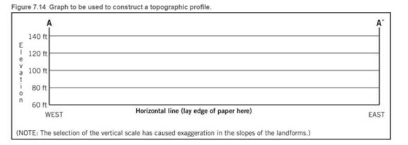
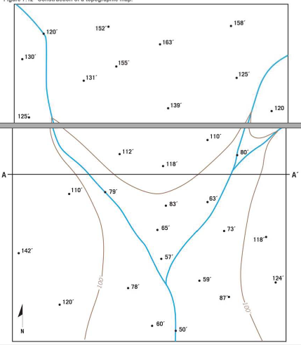
Use the profile graph in Figure 7.14 to construct a west--east profile along the line A- A’ on the contour map you completed in Figure 7.12.
Expert Solution & Answer

Trending nowThis is a popular solution!

Learn your wayIncludes step-by-step video

schedule03:32
Students have asked these similar questions
There is an old axiom (a self-evident or universally recognized truth) of economics that “There is no such thing as a free lunch”. In the United States, stringent, enforced water quality laws and regulations provide a high level of protection of our waters. This is accomplished at a significant cost. For example, (sewage treatment plants use 2% of the electricity produced in the United States. This high level of protection increases the cost of goods manufactured in the United States compared to other nations such as China where standards are lower, enforcement a bit lax and in some cases, non-existent.
What five (5) things could be done to “level the playing field” so that all manufacturers must provide the same degree of water quality protection no matter where in the world they are located? include how each of your ideas will be implemented (ex: which organization will be provided the power and resources to make sure each idea happens). These should be only about water pollution,…
Connecticut is the only state in America where treated industrial and municipal wastewater cannot be discharged to a surface water body used downstream as a source of drinking water. It is legal in all 49 other states. For example, New Orleans, Louisiana takes its drinking water from the Mississippi River which receives discharges of many, many treated municipal and industrial wastewater discharges as well as agricultural runoff from the more than 20 states that are upstream of it. Should other states be required to adopt Connecticut's standard? Why
What is thermal pollution? How can it be controlled?
Chapter 7 Solutions
Applications and Investigations in Earth Science (9th Edition)
Ch. 7.1 - Obtain a stereoscope from your instructor, unfold...Ch. 7.1 - Prob. 2ACh. 7.1 - Prob. 3ACh. 7.1 - Prob. 4ACh. 7.2 - Prob. 1ACh. 7.2 - Prob. 2ACh. 7.3 - Prob. 1ACh. 7.3 - Prob. 3ACh. 7.3 - Prob. 6ACh. 7.4 - Depending on the map scale, 1 inch on a...
Ch. 7.4 - Examine Figure 7.6 and complete the map...Ch. 7.6 - The difference in elevation between adjacent...Ch. 7.6 - What is the difference in elevation between Points...Ch. 7.6 - Notice that every fifth contour line, called an...Ch. 7.6 - Prob. 4ACh. 7.6 - One or more roughly circular closed contours...Ch. 7.6 - Closed contours with hachures short lines that...Ch. 7.6 - When contour lines cross streams or dry stream...Ch. 7.6 - Estimating the elevations of places not located on...Ch. 7.6 - Relief is defined as the difference in elevation...Ch. 7.7 - Use the elevations in Figure 7.12 as a guide for...Ch. 7.7 - Does the land shown on the topographic map you...Ch. 7.7 - Use the profile graph in Figure 7.14 to construct...Ch. 7.8 - Use the profile graph in Figure 7.14 to construct...Ch. 7.9 - What is the contour interval of this map?Ch. 7.9 - What is the difference in elevation from one index...Ch. 7.9 - Prob. 3ACh. 7.9 - Locate the small intermittent stream blue dashed...Ch. 7.9 - What is the approximate elevation of the point...Ch. 7.9 - What is the approximate relief between point X and...Ch. 7.9 - Which of the following phrases best describes the...Ch. 7.9 - The area on both sides of Tennessee Creek in...Ch. 7.9 - Describe the change in elevation you would...Ch. 7.9 - What is the elevation of the town of Leadville,...Ch. 7.9 - Prob. 11ACh. 7 - Determine the contour interval used on this map...Ch. 7 - List the elevations of each index contour on the...Ch. 7 - What are the elevations of the locations...Ch. 7 - What is the elevation of the church? Elevation of...Ch. 7 - Indicate two areas on this map that have steep...Ch. 7 - Describe the relief of Sandy Spit with one of the...Ch. 7 - Mark the top of the hill in the northeast corner...Ch. 7 - Is the top of Picture Ridge, designated Y, at a...Ch. 7 - What is the maximum relief shown on this contour...Ch. 7 - Imagine that you are taking a group of friends...Ch. 7 - Use the satellite images in figure 7.17, which...
Additional Science Textbook Solutions
Find more solutions based on key concepts
WHAT IF? As a cell begins the process of dividing, its chromosomes become shorter, thicker, and individually vi...
Campbell Biology in Focus (2nd Edition)
56. The voltage across a 60 ?F capacitor is described by the equation vC = (18 V)cos(200t), where t is in secon...
College Physics: A Strategic Approach (3rd Edition)
Police Captain Jeffers has suffered a myocardial infarction. a. Explain to his (nonmedically oriented) family w...
Human Physiology: An Integrated Approach (8th Edition)
If someone at the other end of a room smokes a cigarette, you may breathe in some smoke. The movement of smoke ...
Campbell Essential Biology with Physiology (5th Edition)
1.1 Write a one-sentence definition for each of the following:
a. chemistry
b. chemical
Chemistry: An Introduction to General, Organic, and Biological Chemistry (13th Edition)
5. When the phenotype of heterozygotes is intermediate between the phenotypes of the two homozygotes, this patt...
Biology: Life on Earth (11th Edition)
Knowledge Booster

Similar questions
- how can the addition of nutrients such as nitrates and phosphates result in a reduction of the amount of dissolved oxygen in the water?arrow_forwardCongratulations! You have just been selected to be the ruler of China with absolute power! What are the first five things that you would do to protect the environment and human health from water pollution (not other types of pollution)?arrow_forwardWhy is storm water management more of a problem in an urban area than in a rural area?arrow_forward
- Think about natural resource management topics. Which topic or topics, if any, are of most interest to you?arrow_forwardWeathering, erosion, transportation, deposition Compaction, cementation, chemical actions (Lithification) Sediment Igneous rocks Cooling, solidification (Crystallization) Magma From mantle New material Melting added from depth (Metam Heat, inter Sedimentary rocks Metamorphic rocksarrow_forwardDiscussion Question: Essentials of Geography A+ Chapter 1 does a nice job introducing the Physical Earth Sciences with the traditional scientific methods and systems. However, Physical Geography exemplifies understanding spatial patterns. For example, we could research an area's cases of West Nile Virus using a table filled with location and number of deaths and it would be useful. However, an even better way to look at the information in order to search for an underlying pattern and an explanation would be to map the data. For the Chapter 1 Discussion, find a thematic map from your house, the Newspaper, the Internet, the textbook, or wherever you find one! Be sure to include the source such that any of us can get our hands on the same information/map. First DESCRIBE the patterns that you see. Then, INTERPRET the reasons for the pattern. For example,the figures above and below are maps with information plotted. Remember, descriptions are not arguable. Descriptions are factual…arrow_forward
arrow_back_ios
SEE MORE QUESTIONS
arrow_forward_ios
Recommended textbooks for you
 Applications and Investigations in Earth Science ...Earth ScienceISBN:9780134746241Author:Edward J. Tarbuck, Frederick K. Lutgens, Dennis G. TasaPublisher:PEARSON
 Exercises for Weather & Climate (9th Edition)Earth ScienceISBN:9780134041360Author:Greg CarbonePublisher:PEARSON
 Environmental ScienceEarth ScienceISBN:9781260153125Author:William P Cunningham Prof., Mary Ann Cunningham ProfessorPublisher:McGraw-Hill Education
 Earth Science (15th Edition)Earth ScienceISBN:9780134543536Author:Edward J. Tarbuck, Frederick K. Lutgens, Dennis G. TasaPublisher:PEARSON
 Environmental Science (MindTap Course List)Earth ScienceISBN:9781337569613Author:G. Tyler Miller, Scott SpoolmanPublisher:Cengage Learning
 Physical GeologyEarth ScienceISBN:9781259916823Author:Plummer, Charles C., CARLSON, Diane H., Hammersley, LisaPublisher:Mcgraw-hill Education,
Applications and Investigations in Earth Science ...
Earth Science
ISBN:9780134746241
Author:Edward J. Tarbuck, Frederick K. Lutgens, Dennis G. Tasa
Publisher:PEARSON
Exercises for Weather & Climate (9th Edition)
Earth Science
ISBN:9780134041360
Author:Greg Carbone
Publisher:PEARSON
Environmental Science
Earth Science
ISBN:9781260153125
Author:William P Cunningham Prof., Mary Ann Cunningham Professor
Publisher:McGraw-Hill Education
Earth Science (15th Edition)
Earth Science
ISBN:9780134543536
Author:Edward J. Tarbuck, Frederick K. Lutgens, Dennis G. Tasa
Publisher:PEARSON
Environmental Science (MindTap Course List)
Earth Science
ISBN:9781337569613
Author:G. Tyler Miller, Scott Spoolman
Publisher:Cengage Learning
Physical Geology
Earth Science
ISBN:9781259916823
Author:Plummer, Charles C., CARLSON, Diane H., Hammersley, Lisa
Publisher:Mcgraw-hill Education,