
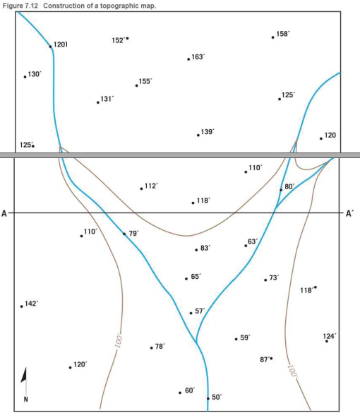
Use the elevations in Figure 7.12 as a guide for drawing contour lines. The 100-foot contour line is provided for reference. Using a 20-foot contour interval, use a pencil to draw a contour line for each 20-foot change in elevation below and above 100 feet (eg. 60 feet, 80 feet, 120 feet) You will have to estimate the elevations between the points. Label each contour line with its elevation

Learn your wayIncludes step-by-step video

Chapter 7 Solutions
Applications and Investigations in Earth Science (9th Edition)
Additional Science Textbook Solutions
Campbell Essential Biology (7th Edition)
Physics for Scientists and Engineers: A Strategic Approach, Vol. 1 (Chs 1-21) (4th Edition)
Cosmic Perspective Fundamentals
Human Anatomy & Physiology (Marieb, Human Anatomy & Physiology) Standalone Book
College Physics: A Strategic Approach (3rd Edition)
Biology: Life on Earth with Physiology (11th Edition)

- I need help with question 3 can someone help me.arrow_forwardI need help with tracing part A could I get some helparrow_forwardActivity 12.3: Wave Refraction Pgs 202-203Figure 12.2 is a map view of a headland along a coastline. The water depths are shown by blue contour lines. As you complete the following questions, assume that waves with a wavelength of 60 feet are approaching the shoreline from the bottom left of the figure. 1. At approximately what water depth-10, 20, 30, or 40 feet-will the approaching waves begin to touch bottom and slow down? (Hint: Recall that this occurs when the water depth is one-half the wavelength.) Approximately the 30-foot depth line. 2. Using the wave shown in Figure 12.2 as a starting point, sketch a series of lines to illustrate the wave refraction that will occur as the wave approaches the shore by following these steps:Step 1: Mark the position on the 30-foot contour line where the wave front will first touch bottom.Step 2: Knowing that the section of the wave that touches bottom will slow down first, sketch the shape of the wave front when it reaches the 20-foot contour…arrow_forward
- N Depth of water contour Advancing wave crest Beach HEADLAND -10'- 20'- -30- Land -40- -50'- 0 Beach Scale 200 feetarrow_forwardI need help on Part C question 2arrow_forwardcan you please show me the drawings for each of these i want to make sure I have them right, as well as explaing the answers, thank youarrow_forward
- I need help on Part Carrow_forwardI need help with part a and barrow_forwardIn fig A13.2.3, what are the gradient and sinuosity of Passage Creek from G and G? Refer to figs. 12.3 and 12.4 for help measuring gradient and sinuosity. Show your calculations. You will graph it later in the activity. Gradient: ______ ft/mi Sinuosity:arrow_forward
- please do these for me and explain in detailarrow_forwardActivity 12.3: Wave Refraction Pgs 202-203Figure 12.2 is a map view of a headland along a coastline. The water depths are shown by blue contour lines. As you complete the following questions, assume that waves with a wavelength of 60 feet are approaching the shoreline from the bottom left of the figure. 1. At approximately what water depth-10, 20, 30, or 40 feet-will the approaching waves begin to touch bottom and slow down? (Hint: Recall that this occurs when the water depth is one-half the wavelength.) 2. Using the wave shown in Figure 12.2 as a starting point, sketch a series of lines to illustrate the wave refraction that will occur as the wave approaches the shore by following these steps:Step 1: Mark the position on the 30-foot contour line where the wave front will first touch bottom.Step 2: Knowing that the section of the wave that touches bottom will slow down first, sketch the shape of the wave front when it reaches the 20-foot contour line.Step 3: Using the same…arrow_forwardN Depth of water contour Advancing wave crest Beach HEADLAND -10- -20- -30' Land -40'- 50- 0 Beach Scale 200 feetarrow_forward
 Applications and Investigations in Earth Science ...Earth ScienceISBN:9780134746241Author:Edward J. Tarbuck, Frederick K. Lutgens, Dennis G. TasaPublisher:PEARSON
 Exercises for Weather & Climate (9th Edition)Earth ScienceISBN:9780134041360Author:Greg CarbonePublisher:PEARSON
 Environmental ScienceEarth ScienceISBN:9781260153125Author:William P Cunningham Prof., Mary Ann Cunningham ProfessorPublisher:McGraw-Hill Education
 Earth Science (15th Edition)Earth ScienceISBN:9780134543536Author:Edward J. Tarbuck, Frederick K. Lutgens, Dennis G. TasaPublisher:PEARSON
 Environmental Science (MindTap Course List)Earth ScienceISBN:9781337569613Author:G. Tyler Miller, Scott SpoolmanPublisher:Cengage Learning
 Physical GeologyEarth ScienceISBN:9781259916823Author:Plummer, Charles C., CARLSON, Diane H., Hammersley, LisaPublisher:Mcgraw-hill Education,