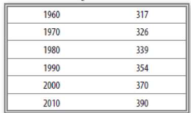
Carbon dioxide is another variable gas that has changed concentration through time. We’ve only measured CO2 since 1958, but in that time it has increased. Use Table 1-3 below to plot the change in general CO2 concentration during the past 50 years.
Table 1-3. CO2 (ppm), 1960–2010.

Learn your wayIncludes step-by-step video

Chapter 1 Solutions
Pearson eText for Exercises for Weather & Climate -- Instant Access (Pearson+)
Additional Science Textbook Solutions
Genetic Analysis: An Integrated Approach (3rd Edition)
Organic Chemistry (8th Edition)
Applications and Investigations in Earth Science (9th Edition)
Biology: Life on Earth with Physiology (11th Edition)
Human Anatomy & Physiology (Marieb, Human Anatomy & Physiology) Standalone Book
Physics for Scientists and Engineers: A Strategic Approach, Vol. 1 (Chs 1-21) (4th Edition)

- List 3 energy conservation tecniquesarrow_forward1. Use the elevations in Figure 7.12 as a guide for drawing contour lines. The 100-foot contour line is provided for reference. Using a 20-foot contour interval, draw a contour line for each 20-foot change in elevation below and above 100 feet (e.g., 60 feet, 80 feet, 120 feet). You will have to estimate the elevations between the points. Label each contour line with its elevation. 2. Does the land shown on the topographic map you constructed generally slope downward toward the north or south? 3. Show the direction each stream is flowing by drawing arrows on the map.arrow_forwardDrawing a Topographic Profile Follow the steps illustrated in Figure 7.13 to draw a topographic profile. Use the profile graph in Figure 7.14 to construct a west-east profile along the line A-A' on the contour map you completed in Figure 7.12. Step 1. Our sample profile will be along line A-A. When constructing profiles on maps provided by your instructor, do not draw on the map. Step 2. Lay a piece of paper along the line of the profile you want to construct. In this example this is line A-A'. Mark each place where a contour line intersects the edge of the paper and note the elevation of the contour line. Step 3. On a separate piece of paper, draw a horizontal line slightly longer than your profile line, A-A'. Select a vertical scale for your profile that begins slightly. below the lowest elevation along the profile and extends slightly beyond the highest elevation. Mark this scale on either side of the horizontal line. Lay the marked paper edge (from Step 2) along the horizontal…arrow_forward
- When contour lines cross streams or dry stream channels, they form a V that points upstream. Draw arrows next to three of the streams (shown in blue) to indicate the direction in which each is flowing.arrow_forwardCoal-burning electric power plants in the Pa Midwest have contributed to acid rain in the eastern United States. Other energy sources would most likely be costlier than coal, thereby raising electricity rates. Should citizens in eastern states be able to pressure utility companies in the Midwest to change their method of generating electricity? What mechanisms might be available to make these changes? How effective are these mechanisms?arrow_forwardWhat renewable energy source provides the majority of renewable energy?arrow_forward
 Applications and Investigations in Earth Science ...Earth ScienceISBN:9780134746241Author:Edward J. Tarbuck, Frederick K. Lutgens, Dennis G. TasaPublisher:PEARSON
 Exercises for Weather & Climate (9th Edition)Earth ScienceISBN:9780134041360Author:Greg CarbonePublisher:PEARSON
 Environmental ScienceEarth ScienceISBN:9781260153125Author:William P Cunningham Prof., Mary Ann Cunningham ProfessorPublisher:McGraw-Hill Education
 Earth Science (15th Edition)Earth ScienceISBN:9780134543536Author:Edward J. Tarbuck, Frederick K. Lutgens, Dennis G. TasaPublisher:PEARSON
 Environmental Science (MindTap Course List)Earth ScienceISBN:9781337569613Author:G. Tyler Miller, Scott SpoolmanPublisher:Cengage Learning
 Physical GeologyEarth ScienceISBN:9781259916823Author:Plummer, Charles C., CARLSON, Diane H., Hammersley, LisaPublisher:Mcgraw-hill Education,