Pearson eText for Exercises for Weather & Climate -- Instant Access (Pearson+)
9th Edition
ISBN: 9780137612949
Author: Greg Carbone
Publisher: PEARSON+
expand_more
expand_more
format_list_bulleted
Textbook Question
Chapter 4, Problem 14E
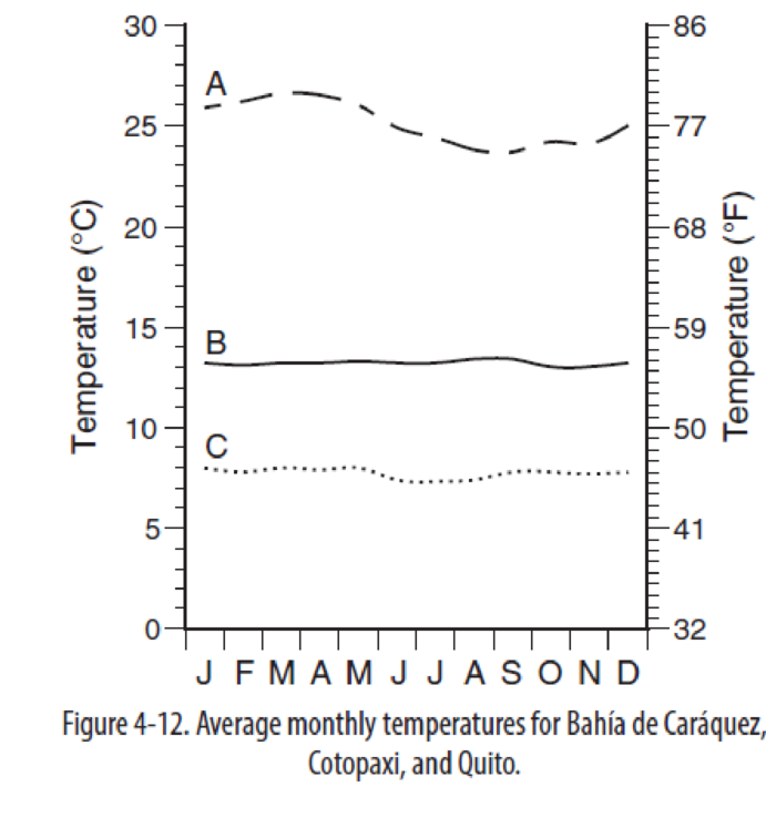
Match Bahía de Caráquez (3 meters), Cotopaxi (3650 meters), and Quito (2811 meters) to the appropriate monthly temperature plot.
A.______________
B. ______________
C. ______________
Expert Solution & Answer

Learn your wayIncludes step-by-step video

schedule03:28
Students have asked these similar questions
Tell us how a geomatics student job position aligns with your studies and career goals.
Name three of the key cartographic components of a map.
Describe in your own words how maps or mapping applications support government decision-making
Chapter 4 Solutions
Pearson eText for Exercises for Weather & Climate -- Instant Access (Pearson+)
Ch. 4 - At 5 N latitude there are two peaks of incident...Ch. 4 - Earth, in its elliptical orbit, is closest to the...Ch. 4 - Describe the general relationship between...Ch. 4 - Why is there little seasonal difference in albedo...Ch. 4 - Examine Figure 4-5 below. When averaged annually,...Ch. 4 - What does Figure 4-5 say about the relationship...Ch. 4 - Using Figure 4-6, describe how the areas of net...Ch. 4 - Use Figure 4-7 to describe how the temperature...Ch. 4 - Summarize the difference in the magnitude and...Ch. 4 - How do the latitudinal gradients of net radiation...
Ch. 4 - Examine Figure 4-9. How does the map help to...Ch. 4 - Figure 4-10 shows monthly average temperature for...Ch. 4 - Note the geographic locations of Durban, South...Ch. 4 - Match Baha de Carquez (3 meters), Cotopaxi (3650...Ch. 4 - Despite the differences caused by elevation, the...Ch. 4 - Prob. 1RQCh. 4 - Prob. 2RQ
Additional Science Textbook Solutions
Find more solutions based on key concepts
8. Animal Athletes
Different animals have very different capacities for running. A horse can maintain a top spe...
College Physics: A Strategic Approach (3rd Edition)
13. The hand in FIGURE Q7.13 is pushing on the back of block A. Blocks A and B, with mB > mA, are connected by ...
Physics for Scientists and Engineers: A Strategic Approach, Vol. 1 (Chs 1-21) (4th Edition)
What distinguishes the mass spectrum of 2,2-dimethylpropane from the mass spectra of pentane and isopentane?
Organic Chemistry (8th Edition)
Another cross in Drosophila involved the recessive, X-linked genes yellow (y), white (w), and cut (ct). A yello...
Concepts of Genetics (12th Edition)
61. What is the pH of a solution in which 224 mL of HCl(g), measured at 27.2 °C and 1.02 atm, is dissolved in 1...
Chemistry: A Molecular Approach (4th Edition)
Explain how the use of an oxygen isotope helped elucidate the chemistry of photosynthesis.
Campbell Biology (11th Edition)
Knowledge Booster

Similar questions
- Name three advantages of using GIS toolsarrow_forward9. In fieldwork-based research, which of the following involves the use of on-site instruments but would be less appropriate for low-frequency events like landslides or extreme floods? a. an ergodic approach b. environmental monitoring c. sampling across spacearrow_forward7. _ The climate-change scientist Mike Hulme has argued that people who tend to see nature as tolerant, and who believe that global climate properties would likely respond very favourably to certain planetary geo-engineering solutions, tend to be: a. egalitarians. b. hierarchists. c. individualists.arrow_forward
- Cronon’s Research on Wilderness – Consider Cronon’s study of wilderness, as discussed by Kanazawa (2023). In what ways, if any, would it have been appropriate for Cronon to have used quantitative methods in his study of the concept of wilderness, and to what end? Why were qualitative methods particularly appropriate for the study, given the nature of his research topic? 150-200 words response to the questionarrow_forwardConsider Cronon’s study of wilderness, as discussed by Kanazawa (2023). In what ways, if any, would it have been appropriate for Cronon to have used quantitative methods in his study of the concept of wilderness, and to what end? Why were qualitative methods particularly appropriate for the study, given the nature of his research topic?arrow_forwardWhy might drought actually cause fire risk to reduce in a desert area?arrow_forward
- Part 1: A completely saturated sample of sandstone has a bulk density of 2.61 g/cm³, an effective porosity of 10 percent, and a total porosity of 12 percent. Determine the density of the solid phase (i.e., the density of the mineral). Part 2: One cubic meter of quartz sand has a dry mass of 2,320 kg. a) Calculate the porosity of the sand. b) Calculate the mass (in kg) of the sand for the following degrees of saturation: 25 percent, 75 percent, 100 percent. Part 3: A sample of quartz sand has a dry mass of 753.7 kg and a volume of 0.36 m³. a) Calculate the porosity of the sand. b) Calculate the mass (in kg) of the sand assuming a degree of saturation equal to 62 percent.arrow_forwardWhat is an oxbow lake and how is it formed?arrow_forwardFor the past 3 million years the earth has experienced glacial-interglacial cycles at regular intervals that coincide with the Milankovitch Cycles. Please briefly describe the three Milankovitch Cycles and their timescales. What is the leading theory for why the timing of glacial-interglacial cycles is connected to these Milankovitch Cycles?arrow_forward
- Why do waterfalls move backwards over time? In your explanation, please use the term “nickpoint”?arrow_forwardThe picture below is of the Kaskawulsh Glacier in Yukon, Canada. What is the name of the type of feature that the red arrows are pointing to in the middle of the glacier and how are these features formed? In your answer please also define the term lateral moraine and how lateral moraines relate to the feature with the red arrows?arrow_forwardit was stated that one major effect of rivers is to flatten out the continents. How do rivers flatten continents?arrow_forward
arrow_back_ios
SEE MORE QUESTIONS
arrow_forward_ios
Recommended textbooks for you
 Applications and Investigations in Earth Science ...Earth ScienceISBN:9780134746241Author:Edward J. Tarbuck, Frederick K. Lutgens, Dennis G. TasaPublisher:PEARSON
 Exercises for Weather & Climate (9th Edition)Earth ScienceISBN:9780134041360Author:Greg CarbonePublisher:PEARSON
 Environmental ScienceEarth ScienceISBN:9781260153125Author:William P Cunningham Prof., Mary Ann Cunningham ProfessorPublisher:McGraw-Hill Education
 Earth Science (15th Edition)Earth ScienceISBN:9780134543536Author:Edward J. Tarbuck, Frederick K. Lutgens, Dennis G. TasaPublisher:PEARSON
 Environmental Science (MindTap Course List)Earth ScienceISBN:9781337569613Author:G. Tyler Miller, Scott SpoolmanPublisher:Cengage Learning
 Physical GeologyEarth ScienceISBN:9781259916823Author:Plummer, Charles C., CARLSON, Diane H., Hammersley, LisaPublisher:Mcgraw-hill Education,
Applications and Investigations in Earth Science ...
Earth Science
ISBN:9780134746241
Author:Edward J. Tarbuck, Frederick K. Lutgens, Dennis G. Tasa
Publisher:PEARSON
Exercises for Weather & Climate (9th Edition)
Earth Science
ISBN:9780134041360
Author:Greg Carbone
Publisher:PEARSON
Environmental Science
Earth Science
ISBN:9781260153125
Author:William P Cunningham Prof., Mary Ann Cunningham Professor
Publisher:McGraw-Hill Education
Earth Science (15th Edition)
Earth Science
ISBN:9780134543536
Author:Edward J. Tarbuck, Frederick K. Lutgens, Dennis G. Tasa
Publisher:PEARSON
Environmental Science (MindTap Course List)
Earth Science
ISBN:9781337569613
Author:G. Tyler Miller, Scott Spoolman
Publisher:Cengage Learning
Physical Geology
Earth Science
ISBN:9781259916823
Author:Plummer, Charles C., CARLSON, Diane H., Hammersley, Lisa
Publisher:Mcgraw-hill Education,