
Applications and Investigations in Earth Science (9th Edition)
9th Edition
ISBN: 9780134746241
Author: Edward J. Tarbuck, Frederick K. Lutgens, Dennis G. Tasa
Publisher: PEARSON
expand_more
expand_more
format_list_bulleted
Textbook Question
Chapter 12.2, Problem 4A
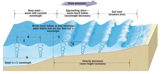
As waves approach the shore, do their heights increase or decrease? Do wavelengths become longer or shorter?
Expert Solution & Answer

Learn your wayIncludes step-by-step video

schedule01:27
Students have asked these similar questions
Draw a cross section with a tree growing out of Earth’s surface (so I know which side is the surface). Add a dipping joint and label the hanging wall and footwall blocks.
Draw a second cross section (again with a tree on the surface of the Earth) that shows how Earth’s surface would be offset along this joint if it turned into a normal fault. Label the hanging wall and footwall and use arrows to indicate the motion of the hanging wall relative to the footwall.
Now draw a third cross section with all the same elements as in parts A and B, but for a trust/reverse fault.
Imagine the same cross section either in three dimensions, or in a bird’s-eye view from top down. Draw what this area would look like after a right-lateral strike-slip fault. Label the strike of the fault and use arrows to show directions of movement
Examine the strike and dip of the rock units on the Devil's Fence geologic map in Figure 6.21. Draw multiple large arrows on the map, pointing in the direction of dip on several rock units.
Do the rock layers located near the center of the map in Section 14 dip toward the northwest or southeast?
The same rocks in Section 14 are also found in Section 18. Do the rocks in Section 18 dip toward the east or west?
What is the approximate angle of dip of the units in Section 18?
1. Draw a dashed line representing the hinge line of the large geologic structure that occupies most of the map. Label the hinge line.
2. Are the rocks getting older or younger farther from the hinge line?
3. Is this geologic structure a plunging anticline or syncline?
4. Provide two lines of evidence that support your answer to Question 8.
Chapter 12 Solutions
Applications and Investigations in Earth Science (9th Edition)
Ch. 12.1 - Prob. 1ACh. 12.1 - Below what depth would a submarine have to...Ch. 12.2 - Prob. 1ACh. 12.2 - Near the shore in shallow water, do water...Ch. 12.2 - In shallow water, are water particles in the wave...Ch. 12.2 - As waves approach the shore, do their heights...Ch. 12.2 - In the surf zone, is the water in the crest of a...Ch. 12.2 - What is the velocity of deep-water waves that have...Ch. 12.2 - At what water depth will a deep-water wave with a...Ch. 12.2 - At what water depth will the wave described in...
Ch. 12.2 - What two factors determine how far from the...Ch. 12.2 - Imagine that you are standing on a beach but...Ch. 12.2 - Along some shorelines, incoming waves cause the...Ch. 12.2 - One type of ocean wave, call a tsunami, is usually...Ch. 12.3 - Prob. 1ACh. 12.3 - At approximately what water depth- 3, 6, 12, or 24...Ch. 12.3 - Draw a dashed line on Figure 12.2 to indicate...Ch. 12.3 - Will wave erosion be most severe on the headland...Ch. 12.3 - What effect will the concentrated energy from wave...Ch. 12.4 - Prob. 1ACh. 12.4 - Name three shoreline features that are produced,...Ch. 12.4 - Use an arrow to indicate the location and...Ch. 12.4 - Use an arrow to indicate the location and...Ch. 12.5A - Prob. 1ACh. 12.5A - Next to each of the features listed below,...Ch. 12.5A - Label a moraine terrace, a wave-cut cliff, and a...Ch. 12.5A - Label a baymouth bar and a spit in Figure 12.8.Ch. 12.5A - Label a sea arch, a tombolo, a spit, a wave-cut...Ch. 12.5B - Prob. 1ACh. 12.5B - Point Reyes, located in the bottom-left corner of...Ch. 12.5B - Several depositional features near Drakes Estero...Ch. 12.5B - Follow Limantour Spit from its western tip at the...Ch. 12.5B - What geologic feature is Estero de Limantour?Ch. 12.5B - Limantour Spit may eventually extend across the...Ch. 12.5B - Locate the bench mark BM with an elevation of 552...Ch. 12.5B - What feature indicates that the headland called...Ch. 12.5B - List at least two features on the map that are...Ch. 12.6 - Prob. 1ACh. 12.6 - Which surface-ocean current travels completely...Ch. 12.6 - Which surface-ocean current flows along the...Ch. 12.6 - What is the name of the surface-ocean current...Ch. 12.6 - Is the general circulation of the surface currents...Ch. 12.6 - In the South Atlantic, is the general circulation...Ch. 12.7 - Prob. 1ACh. 12.7 - What process causes the Mediterranean intermediate...Ch. 12.7 - Figure 12.13 illustrates a simplified model of...Ch. 12.7 - Assume that water sinking in the North Atlantic...Ch. 12.8A - Prob. 1ACh. 12.8A - Write the word spring or neap above the period of...Ch. 12.8A - Which coastal area experiences the largest tidal...Ch. 12.8A - Which coastal area experiences the smallest tidal...Ch. 12.8A - Notice that the phases of the Moon are shown at...Ch. 12.8B - Prob. 1ACh. 12.8B - Classify each of the tidal patterns shown in...Ch. 12.8C - Prob. 1ACh. 12.8C - Prob. 2ACh. 12.8C - Prob. 3ACh. 12.8C - Prob. 4ACh. 12.8C - Prob. 5ACh. 12 - Prob. 1LRCh. 12 - What happens to wavelength and wave height as a...Ch. 12 - Refer 10 Figure 12.16 page 214 Identify the tidal...Ch. 12 - Is the circulation of the surface-ocean currents...Ch. 12 - Describe the difference between a spring tide and...Ch. 12 - Explain what causes spring tides.Ch. 12 - During which lunar phases are neap tides most...Ch. 12 - Which of the tidal patterns illustrated in Figure...Ch. 12 - On Figure 12.20, page 218, identify the features...
Additional Science Textbook Solutions
Find more solutions based on key concepts
48. Four solutions of unknown NaOH concentration are titrated with solutions of HCl. The following table lists ...
Introductory Chemistry (6th Edition)
Name the components (including muscles) of the thoracic cage. List the contents of the thorax.
Human Physiology: An Integrated Approach (8th Edition)
The genes dumpy (dp), clot (cl), and apterous (ap) are linked on chromosome II of Drosophila. In a series of tw...
Concepts of Genetics (12th Edition)
17.58 calculate the solubility of LaF3 in grams per liter in
a. pure water,
b. 0.010 M KF solution.
...
Chemistry: The Central Science (14th Edition)
Explain all answers clearly, using complete sentence and proper essay structure if needed. An asterisk (*) desi...
Cosmic Perspective Fundamentals
Draw the mechanism for the hydroxide ion-catalyzed cleavage of fructose-l.6-bisphosphate.
Organic Chemistry (8th Edition)
Knowledge Booster

Similar questions
- On the map in Figure 6.21, write the word oldest where the oldest sedimentary rock unit is exposed at the sur-face and the word youngest where the youngest sedimentary rocks occur.arrow_forwardDiscussion Question: Glacial (or Ice) and Periglacial Landscapes A+ The Ice and Glaciers chapter focuses on the Cryosphere, the ice on our planet. I always find it interesting to consider the Earth's Hydrologic Cycle, our water in all of the different phases: solid ice, liquid water, and water vapor (a gas). In place number one for the majority of the World's water, we have the oceans. In place number two, we have ice. Neither one is available to us for drinking water at this point. Amazingly enough, in place number three is groundwater before lakes and streams. Water has led to many problems in the history of California, the United States, and even the world. Nevada Idaho B) at Flats el Mone Lake Arizona Severe Dry Lake (c) Mono Lake, tufa towersarrow_forwardDiscussion Question: River (or Stream) Systems A+ Should New Orleans have been reconstructed or not? 94 (b) 40 80 MILES Louisiana 40 80 KILOMETERS Old River Control Project Alexandria 93 Gulf of Mexico 92 Lake Pontobartrain Now Orleans Morgan City H High pressure PACIFIC OCEAN 30- General region of 150%+ precipitation during summer CP Cool, dry air Jer stream shed south Divergence mT air mass is pumped into the Midwest for weeks 400 800 MILES 400 800 KILOMETERS 120° Heal wave High pressure Stagnant air m Warm, wet unstable ATLANTIC OCEAN Tropic of Cancer 91 89 ° 110° 70°arrow_forward
- Los Angeles's demand for water exceeds the amount of water available. There are no other new sources of water available, so Los Angeles is planning on constructing the high technology facilities necessary to produce drinking water from treated municipal wastewater (i.e. "Toilet to Tap"). Public perception (i.e. the "yuch! factor"), not well established, proven technology, to accomplish this task, is going to be the big problem. Develop a five (5) item marketing plan to convince the "beautiful" people of Los Angeles that drinking water that is recycled sewage that exceeds all U.S. EPA drinking water standards. This can be done because as Slide 63 shows, doctors once were used to sell Lucky Strike cigarettes - "Your throat protection: against irritation, against cough". Cigarettes, as is now known are harmful to your health while the drinking water produced from sewage is of equal quality and in many instances higher quality than your existing drinking water.arrow_forwardRead June 17, 2023, editorial from the Wall Street Journal entitled "Biden's Fishy Plan to Breach the Snake River Dams. The editorial raises a number of concerns about the plans of the administration of President Joseph Robinette Biden to remove four hydroelectric dams from the Snake River in southeastern Washington. Your responsibility for this Exercise is to list five (5) of the concerns raised in the editorial and provide fact-based arguments (NOT YOUR PERSONAL OPINION), including references from sources other than the editorial, either supporting or disagreeing with each of the five (5) concerns.arrow_forwardShould the United States allow Mexico to have water from the Rio Grande and the Colorado River, both of which originate in the United States and flow to Mexico?arrow_forward
- What are the similarities between domestic and industrial water use? How are they different from in-stream use?arrow_forwardDo you believe that large-scale hydroelectric power plants should be promoted as a renewable alternative to power plants that burn fossil fuels? What criteria do you use for this decision?arrow_forwardDo nonfarmers have an interest in how water is used for irrigation? Under what conditions should the general public be involved in making these decisions along with the farmers who are directly involved?arrow_forward
arrow_back_ios
SEE MORE QUESTIONS
arrow_forward_ios
Recommended textbooks for you
 Applications and Investigations in Earth Science ...Earth ScienceISBN:9780134746241Author:Edward J. Tarbuck, Frederick K. Lutgens, Dennis G. TasaPublisher:PEARSON
 Exercises for Weather & Climate (9th Edition)Earth ScienceISBN:9780134041360Author:Greg CarbonePublisher:PEARSON
 Environmental ScienceEarth ScienceISBN:9781260153125Author:William P Cunningham Prof., Mary Ann Cunningham ProfessorPublisher:McGraw-Hill Education
 Earth Science (15th Edition)Earth ScienceISBN:9780134543536Author:Edward J. Tarbuck, Frederick K. Lutgens, Dennis G. TasaPublisher:PEARSON
 Environmental Science (MindTap Course List)Earth ScienceISBN:9781337569613Author:G. Tyler Miller, Scott SpoolmanPublisher:Cengage Learning
 Physical GeologyEarth ScienceISBN:9781259916823Author:Plummer, Charles C., CARLSON, Diane H., Hammersley, LisaPublisher:Mcgraw-hill Education,
Applications and Investigations in Earth Science ...
Earth Science
ISBN:9780134746241
Author:Edward J. Tarbuck, Frederick K. Lutgens, Dennis G. Tasa
Publisher:PEARSON
Exercises for Weather & Climate (9th Edition)
Earth Science
ISBN:9780134041360
Author:Greg Carbone
Publisher:PEARSON
Environmental Science
Earth Science
ISBN:9781260153125
Author:William P Cunningham Prof., Mary Ann Cunningham Professor
Publisher:McGraw-Hill Education
Earth Science (15th Edition)
Earth Science
ISBN:9780134543536
Author:Edward J. Tarbuck, Frederick K. Lutgens, Dennis G. Tasa
Publisher:PEARSON
Environmental Science (MindTap Course List)
Earth Science
ISBN:9781337569613
Author:G. Tyler Miller, Scott Spoolman
Publisher:Cengage Learning
Physical Geology
Earth Science
ISBN:9781259916823
Author:Plummer, Charles C., CARLSON, Diane H., Hammersley, Lisa
Publisher:Mcgraw-hill Education,