
On Figure 12.20, page 218, identify the features associated with an evolving shoreline, using the following terms spit, wave-cut cliff, beach deposits, baymouth bar, wave-cut platform, tombolo, sea arch, longshore current, and sea stack (Note -Terms may be used more than once )
Figure 12.20 Illustrations and images of changes that can take place, through time, along an initially irregular coastline that remains tectonically stable.
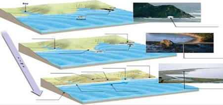
| a. | Is the shoreline shown in this Image a submergent shoreline or an emergent shoreline? |
| b. | Label the shoreline features on the image. |
| c. | Place an X on the highest marine terrace shown In this Image. |

Trending nowThis is a popular solution!

Learn your wayIncludes step-by-step video

Chapter 12 Solutions
Applications and Investigations in Earth Science (9th Edition)
Additional Science Textbook Solutions
Cosmic Perspective Fundamentals
Human Anatomy & Physiology (2nd Edition)
Campbell Biology (11th Edition)
Laboratory Experiments in Microbiology (12th Edition) (What's New in Microbiology)
Chemistry: An Introduction to General, Organic, and Biological Chemistry (13th Edition)
Microbiology: An Introduction

- 1. Use the PLS system to label the townships along the western edge and ranges along the bottom of Part A. 2. Use the PLS system to label each of the sections in the congressional township shown in Part B. 3. In the space provided below, use the PLS system to describe Plots Y and Z. Plot X has been completed as an example.arrow_forwardSOUTH Judith River Eagle Warm Mowry Shak Kooter Thermope Jurassic Ellis Seyenite Porphry Metamorphic Rocks Gravity-Slide Faults Bearpaw Shale 3 Mississippian Mission Canyph Devonian Jefferson Limestone an Platheadbandstor Bakken/3 Forks Shale NORTH Ordovician Bighorn Dolomite Little Rocky Mountains No Scale - Drawing is approximate length of Reservation Hogeland Basin Creating a cross-section requires some subjective decisions on your part, but it needs to be geologically reasonable. For example, the thickness and dip of a planar layer should remain relatively constant unless the map data requires otherwise. Planar layers should also be laterally continuous unless there is evidence otherwise. Similarly, keep the structure as simple as you can. Steps to producing a cross section: I. Choose the location and direction of the profile on the geological map (usually a straight line) II. Draw or plot the topography of the profile on the cross-section III. Add the geological features from the…arrow_forwardsecond question plssarrow_forward
- H D Figure 13.14 4 v C ax. G Figure 13.15 JV T R K 5 ७ हाकालयकाळात Oldest Younges! Oldest 10arrow_forwardPretty much all the solidified lava you see near Kilauea and Mauna Loa is basalt. Using just the satellite imagery, how would you know that these lavas are basaltic (as opposed to andesitic or rhyolitic)?arrow_forwardCompare a passive solar heating system with an active solar heating system.arrow_forward
- Describe what the wind power as an energy source is. Describe 5 advantages of wind power as an energy source. Describe 5 disadvantages of wind power as an energy source. Discuss the future potential wind power as an energy source in the United States. Describe how you would convince the residents of the State of Connecticut to utilize more wind power as an energy sourcearrow_forwardHow is the biofuel ethanol produced?arrow_forwardDistinguish between reserves and resoircesarrow_forward
- Describe what kind of energy source oil ia. Describe 5 advantages of oil as an energy source. Describe 5 disadvantages of oil as energy source. Discuss the future potential of oil as energy source in the United States. Describe how you would convince the residents of the State of Connecticut to utilize more oil as an energy source.arrow_forwardWhat are negative environmental impacts of developing hydroelectric power?arrow_forwardList three negative environmental impacts of using biomass to provide energy.arrow_forward
 Applications and Investigations in Earth Science ...Earth ScienceISBN:9780134746241Author:Edward J. Tarbuck, Frederick K. Lutgens, Dennis G. TasaPublisher:PEARSON
 Exercises for Weather & Climate (9th Edition)Earth ScienceISBN:9780134041360Author:Greg CarbonePublisher:PEARSON
 Environmental ScienceEarth ScienceISBN:9781260153125Author:William P Cunningham Prof., Mary Ann Cunningham ProfessorPublisher:McGraw-Hill Education
 Earth Science (15th Edition)Earth ScienceISBN:9780134543536Author:Edward J. Tarbuck, Frederick K. Lutgens, Dennis G. TasaPublisher:PEARSON
 Environmental Science (MindTap Course List)Earth ScienceISBN:9781337569613Author:G. Tyler Miller, Scott SpoolmanPublisher:Cengage Learning
 Physical GeologyEarth ScienceISBN:9781259916823Author:Plummer, Charles C., CARLSON, Diane H., Hammersley, LisaPublisher:Mcgraw-hill Education,