
On Figure 12.20, page 218, identify the features associated with an evolving shoreline, using the following terms spit, wave-cut cliff, beach deposits, baymouth bar, wave-cut platform, tombolo, sea arch, longshore current, and sea stack (Note -Terms may be used more than once )
Figure 12.20 Illustrations and images of changes that can take place, through time, along an initially irregular coastline that remains tectonically stable.
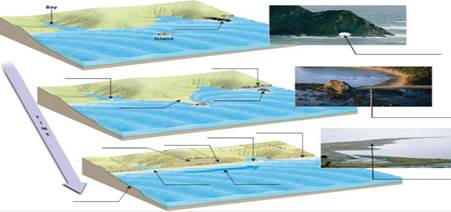
| a. | Is the shoreline shown in this Image a submergent shoreline or an emergent shoreline? |
| b. | Label the shoreline features on the image. |
| c. | Place an X on the highest marine terrace shown In this Image. |

Trending nowThis is a popular solution!

Learn your wayIncludes step-by-step video

Chapter 12 Solutions
APPL.+INVES.IN EARTHSCI.+MASTERING GEOL
Additional Science Textbook Solutions
Cosmic Perspective Fundamentals
Human Anatomy & Physiology (2nd Edition)
Campbell Biology (11th Edition)
Laboratory Experiments in Microbiology (12th Edition) (What's New in Microbiology)
Chemistry: An Introduction to General, Organic, and Biological Chemistry (13th Edition)
Microbiology: An Introduction

- On the map in Figure 6.21, write the word oldest where the oldest sedimentary rock unit is exposed at the sur-face and the word youngest where the youngest sedimentary rocks occur.arrow_forwardDiscussion Question: Glacial (or Ice) and Periglacial Landscapes A+ The Ice and Glaciers chapter focuses on the Cryosphere, the ice on our planet. I always find it interesting to consider the Earth's Hydrologic Cycle, our water in all of the different phases: solid ice, liquid water, and water vapor (a gas). In place number one for the majority of the World's water, we have the oceans. In place number two, we have ice. Neither one is available to us for drinking water at this point. Amazingly enough, in place number three is groundwater before lakes and streams. Water has led to many problems in the history of California, the United States, and even the world. Nevada Idaho B) at Flats el Mone Lake Arizona Severe Dry Lake (c) Mono Lake, tufa towersarrow_forwardDiscussion Question: River (or Stream) Systems A+ Should New Orleans have been reconstructed or not? 94 (b) 40 80 MILES Louisiana 40 80 KILOMETERS Old River Control Project Alexandria 93 Gulf of Mexico 92 Lake Pontobartrain Now Orleans Morgan City H High pressure PACIFIC OCEAN 30- General region of 150%+ precipitation during summer CP Cool, dry air Jer stream shed south Divergence mT air mass is pumped into the Midwest for weeks 400 800 MILES 400 800 KILOMETERS 120° Heal wave High pressure Stagnant air m Warm, wet unstable ATLANTIC OCEAN Tropic of Cancer 91 89 ° 110° 70°arrow_forward
- Los Angeles's demand for water exceeds the amount of water available. There are no other new sources of water available, so Los Angeles is planning on constructing the high technology facilities necessary to produce drinking water from treated municipal wastewater (i.e. "Toilet to Tap"). Public perception (i.e. the "yuch! factor"), not well established, proven technology, to accomplish this task, is going to be the big problem. Develop a five (5) item marketing plan to convince the "beautiful" people of Los Angeles that drinking water that is recycled sewage that exceeds all U.S. EPA drinking water standards. This can be done because as Slide 63 shows, doctors once were used to sell Lucky Strike cigarettes - "Your throat protection: against irritation, against cough". Cigarettes, as is now known are harmful to your health while the drinking water produced from sewage is of equal quality and in many instances higher quality than your existing drinking water.arrow_forwardRead June 17, 2023, editorial from the Wall Street Journal entitled "Biden's Fishy Plan to Breach the Snake River Dams. The editorial raises a number of concerns about the plans of the administration of President Joseph Robinette Biden to remove four hydroelectric dams from the Snake River in southeastern Washington. Your responsibility for this Exercise is to list five (5) of the concerns raised in the editorial and provide fact-based arguments (NOT YOUR PERSONAL OPINION), including references from sources other than the editorial, either supporting or disagreeing with each of the five (5) concerns.arrow_forwardShould the United States allow Mexico to have water from the Rio Grande and the Colorado River, both of which originate in the United States and flow to Mexico?arrow_forward
- What are the similarities between domestic and industrial water use? How are they different from in-stream use?arrow_forwardDo you believe that large-scale hydroelectric power plants should be promoted as a renewable alternative to power plants that burn fossil fuels? What criteria do you use for this decision?arrow_forwardDo nonfarmers have an interest in how water is used for irrigation? Under what conditions should the general public be involved in making these decisions along with the farmers who are directly involved?arrow_forward
 Applications and Investigations in Earth Science ...Earth ScienceISBN:9780134746241Author:Edward J. Tarbuck, Frederick K. Lutgens, Dennis G. TasaPublisher:PEARSON
 Exercises for Weather & Climate (9th Edition)Earth ScienceISBN:9780134041360Author:Greg CarbonePublisher:PEARSON
 Environmental ScienceEarth ScienceISBN:9781260153125Author:William P Cunningham Prof., Mary Ann Cunningham ProfessorPublisher:McGraw-Hill Education
 Earth Science (15th Edition)Earth ScienceISBN:9780134543536Author:Edward J. Tarbuck, Frederick K. Lutgens, Dennis G. TasaPublisher:PEARSON
 Environmental Science (MindTap Course List)Earth ScienceISBN:9781337569613Author:G. Tyler Miller, Scott SpoolmanPublisher:Cengage Learning
 Physical GeologyEarth ScienceISBN:9781259916823Author:Plummer, Charles C., CARLSON, Diane H., Hammersley, LisaPublisher:Mcgraw-hill Education,