Concept explainers
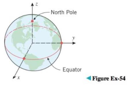
The Earth’s rotation causes a flattening at the poles, so its shape is often modeled as an oblate spheroid rather than a sphere (see Exercise 53 for terminology). One of the models used by global positioning satellites is the World Geodetic System of 1984 (WGS-84), which treats the Earth as an oblate spheroid whose equatorial radius is 6378.1370 km and whose polar radius (the distance from the Earth’s center to the poles) is 6356.5231 km. Use the WGS-84 model to find an equation for the surface of the Earth relative to the

Want to see the full answer?
Check out a sample textbook solution
Chapter 11 Solutions
EBK CALCULUS EARLY TRANSCENDENTALS SING
Additional Math Textbook Solutions
Basic Business Statistics, Student Value Edition
Elementary Statistics
Introductory Statistics
Calculus: Early Transcendentals (2nd Edition)
Thinking Mathematically (6th Edition)
University Calculus: Early Transcendentals (4th Edition)
- I do not understand your writing, and can you explane it any more?arrow_forwardA bridge is built in the shape of a parabolic arch. The bridge has a span of s = 180 feet and a maximum height of h = 25 feet. Choose a suitable rectangular coordinate system and find the height of the arch at distances of 10, 30, and 50 feet from the center.arrow_forwardWrite the equation of a sphere of radius 3 in all three coordinates--cartesian, cylindrical, and spherical.arrow_forward
- Estimate the length of the major axis of the orbit of Uranus if its orbital period is 84 years.arrow_forwardA suspension bridge with weight uniformly distributed along its length has twin towers that extend 50 meters above the road surface and are 1600 meters apart. The cables are parabolic in shape and are suspended from the tops of the towers. The cables touch the road surface at the center of the bridge. Find the height of the cables at a point 400 meters from the center. (Assume that the road is level.) The height of the cables is (Simplify your answer.) meters.arrow_forwardRegarding the orbit of the planet Mercury, we know, according to the National Encyclopedia, that it is an ellipse and that the minimum distance to the sun is 0.31 AU and that the maximum distance is 0.47 AU, where 1AU (astronomical unit) = 149, 6 · 109m = Earth's average distance to the sun. We also know that Mercury's orbital period around the sun is 87, 97 days.Calculate the length (km) of Mercury's orbit around the sun and the average velocity of the planet (km / h).arrow_forward
- In September 2009, Australian astronomer Robert H. McNaught discovered comet C/2009 R1 (McNaught). The orbit of this comet is hyperbolic with the Sun at one focus. Because the orbit is not elliptical, the comet will not be captured by the Sun's gravitational pull and instead will pass by the Sun only once. The comet reached perihelion on July 2, 2010. (Source: Minor Planet Center, http://minorplanetcenter.net/) The path of the comet can be modeled by the equation (1191.2) (30.9) where x and y are measured in AU (astronomical units). a. Determine the distance (in AU) at perihelion. Round to 1 decimal place. b. Using the rounded value from part (a), if 1 AU = 93,000,000 mi, find the distance in miles. Perihelion distance (0, 0) "Sunarrow_forwardFormulate and solve problems involving geomelric figures on the rectangular coordinate plane with perseverance and accuracy. In Barangay Dao, the Barangay Disaster Risk Reduction and Management Council was preparing the plan for their immediate response. They need to draw the map of the community using a gridl in which each unit represents I km. The Barangay Hall is located at point (1,2) and different places are as follows: Church (5, 4), Dao Elem. School (0, 3), Dao National High School (8, 5), Market (-1, 7), Health Center (4 ,2), Day Care Center ( 6, 0) and Basketball Court ( 4, 6 ). Let's help the BDRRM, draw the following landmarks in a coordinate plane. Use different geometric figures to indicate the places. Find the distances of different landmarks. 1. Barangay Hall to Church 2. Barangay Hall to Dao Elementary School 3. Barangay Hall to Dao National High School 4. Dao National High School to Basketball Court 5. Baskelball Court to Market 18arrow_forwardThe LORAN (LOng RAnge Navigation) radio navigation system was widely used until the 1990s when it was superseded by the GPS system. In the LORAN system, two radio stations located at A and B transmit simultaneous signals to a ship or an aircraft located at P. The onboard computer converts the time difference in receiving these signals into a distance difference |PA|-|PBI, and this, according to the definition of a hyperbola, locates the ship or aircraft on one branch of a hyperbola (see the figure). coastline 360 ml transmitting stations Suppose that station B is located 360 mi due east of station A on a coastline. A ship received the signal from B 1,100 microseconds (us) before it received the signal from A. (a) Assuming that radio signals travel at a speed of 980 ft/us, find an equation of the hyperbola on which the ship lies. (Use x as the axis along the coastline, and center your coordinate system between A and B. Values should be in miles.) (b) If the ship is due north of B, how…arrow_forward
- Algebra & Trigonometry with Analytic GeometryAlgebraISBN:9781133382119Author:SwokowskiPublisher:Cengage
 Holt Mcdougal Larson Pre-algebra: Student Edition...AlgebraISBN:9780547587776Author:HOLT MCDOUGALPublisher:HOLT MCDOUGAL
 Elementary Linear Algebra (MindTap Course List)AlgebraISBN:9781305658004Author:Ron LarsonPublisher:Cengage Learning
 Mathematics For Machine TechnologyAdvanced MathISBN:9781337798310Author:Peterson, John.Publisher:Cengage Learning,
 Elementary Geometry For College Students, 7eGeometryISBN:9781337614085Author:Alexander, Daniel C.; Koeberlein, Geralyn M.Publisher:Cengage,


