Decode information from each of the following station models:

Sea-level pressure ___________
Temperature ___________
Dew-point temperature ___________
Sky coverage ___________
Current weather ___________
Sea-level pressure ___________
Temperature ___________
Dew-point temperature ___________
Sky coverage ___________
Wind speed ___________
Wind direction ___________
Pressure change during last three hours ___________
Pressure tendency ___________
Sea-level pressure ___________
Temperature ___________
Dew-point temperature ___________
Sky coverage ___________
(a)
Decode information from each of the following station models:
Answer to Problem 1E
Sea-level pressure 1002.4 mb
Temperature 37⁰ F
Dew-point temperature 21⁰ F
Sky coverage CLEAR
Explanation of Solution
The given diagram represents an area with sea-level pressure 1002.4 mb. Temperature 37⁰ F, dew-point temperature with clear sky coverage. Values are identified using reference symbols given in the weather map lab analysis material.
(b)
Decode information from each of the following station models:
Answer to Problem 1E
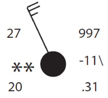
Current weather CONTINUOUS LIGHT SNOW
Sea-level pressure 999.7 mb
Temperature 27⁰ F
Dew-point temperature 20⁰ F
Sky coverage OVERCAST
Wind speed 23-27 KNOTS
Wind direction NORTH WEST
Pressure change
during last three hours 1.1 mb
Pressure tendency FALLING
Explanation of Solution
The given diagram represents an area with sea-level pressure 999.7 mb. Temperature 27⁰ F, dew-point temperature 20⁰ F with cloudy sky. The current weather of the area is continuous light snow. This weather represents a dry, windy conditions of the area because of high wind, low temperature and dew point temperature. Chances of rain are expected due to falling pressure. Values are identified using reference symbols given in the weather map lab analysis material.
(c)
Decode information from each of the following station models:
Answer to Problem 1E
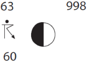
Sea-level pressure 999.8 mb
Temperature 63⁰ F
Dew-point temperature 60⁰ F
Sky coverage PARTLY CLOUDY
Current weather THUNDER WITH LIGHT RAIN
Explanation of Solution
The given diagram represents an area with sea-level pressure 999.8 mb. Temperature 63⁰ F, dew-point temperature 60⁰ F with partly cloudy sky. The current weather of the area is light rain with thunderstorms. Values are identified using reference symbols given in the weather map lab analysis material.
Want to see more full solutions like this?
Chapter 9 Solutions
EBK EXERCISES FOR WEATHER & CLIMATE
Additional Science Textbook Solutions
Biology: Life on Earth with Physiology (11th Edition)
Microbiology: An Introduction
Human Physiology: An Integrated Approach (8th Edition)
Introductory Chemistry (6th Edition)
The Cosmic Perspective (8th Edition)
Physics for Scientists and Engineers: A Strategic Approach, Vol. 1 (Chs 1-21) (4th Edition)

- Name three advantages of using GIS toolsarrow_forward9. In fieldwork-based research, which of the following involves the use of on-site instruments but would be less appropriate for low-frequency events like landslides or extreme floods? a. an ergodic approach b. environmental monitoring c. sampling across spacearrow_forward7. _ The climate-change scientist Mike Hulme has argued that people who tend to see nature as tolerant, and who believe that global climate properties would likely respond very favourably to certain planetary geo-engineering solutions, tend to be: a. egalitarians. b. hierarchists. c. individualists.arrow_forward
- Cronon’s Research on Wilderness – Consider Cronon’s study of wilderness, as discussed by Kanazawa (2023). In what ways, if any, would it have been appropriate for Cronon to have used quantitative methods in his study of the concept of wilderness, and to what end? Why were qualitative methods particularly appropriate for the study, given the nature of his research topic? 150-200 words response to the questionarrow_forwardConsider Cronon’s study of wilderness, as discussed by Kanazawa (2023). In what ways, if any, would it have been appropriate for Cronon to have used quantitative methods in his study of the concept of wilderness, and to what end? Why were qualitative methods particularly appropriate for the study, given the nature of his research topic?arrow_forwardWhy might drought actually cause fire risk to reduce in a desert area?arrow_forward
- Part 1: A completely saturated sample of sandstone has a bulk density of 2.61 g/cm³, an effective porosity of 10 percent, and a total porosity of 12 percent. Determine the density of the solid phase (i.e., the density of the mineral). Part 2: One cubic meter of quartz sand has a dry mass of 2,320 kg. a) Calculate the porosity of the sand. b) Calculate the mass (in kg) of the sand for the following degrees of saturation: 25 percent, 75 percent, 100 percent. Part 3: A sample of quartz sand has a dry mass of 753.7 kg and a volume of 0.36 m³. a) Calculate the porosity of the sand. b) Calculate the mass (in kg) of the sand assuming a degree of saturation equal to 62 percent.arrow_forwardWhat is an oxbow lake and how is it formed?arrow_forwardFor the past 3 million years the earth has experienced glacial-interglacial cycles at regular intervals that coincide with the Milankovitch Cycles. Please briefly describe the three Milankovitch Cycles and their timescales. What is the leading theory for why the timing of glacial-interglacial cycles is connected to these Milankovitch Cycles?arrow_forward
- Why do waterfalls move backwards over time? In your explanation, please use the term “nickpoint”?arrow_forwardThe picture below is of the Kaskawulsh Glacier in Yukon, Canada. What is the name of the type of feature that the red arrows are pointing to in the middle of the glacier and how are these features formed? In your answer please also define the term lateral moraine and how lateral moraines relate to the feature with the red arrows?arrow_forwardit was stated that one major effect of rivers is to flatten out the continents. How do rivers flatten continents?arrow_forward
 Applications and Investigations in Earth Science ...Earth ScienceISBN:9780134746241Author:Edward J. Tarbuck, Frederick K. Lutgens, Dennis G. TasaPublisher:PEARSON
 Exercises for Weather & Climate (9th Edition)Earth ScienceISBN:9780134041360Author:Greg CarbonePublisher:PEARSON
 Environmental ScienceEarth ScienceISBN:9781260153125Author:William P Cunningham Prof., Mary Ann Cunningham ProfessorPublisher:McGraw-Hill Education
 Earth Science (15th Edition)Earth ScienceISBN:9780134543536Author:Edward J. Tarbuck, Frederick K. Lutgens, Dennis G. TasaPublisher:PEARSON
 Environmental Science (MindTap Course List)Earth ScienceISBN:9781337569613Author:G. Tyler Miller, Scott SpoolmanPublisher:Cengage Learning
 Physical GeologyEarth ScienceISBN:9781259916823Author:Plummer, Charles C., CARLSON, Diane H., Hammersley, LisaPublisher:Mcgraw-hill Education,