Applications and Investigations in Earth Science Plus Mastering Geology with Pearson eText -- Access Card Package (9th Edition) (What's New in Geosciences)
9th Edition
ISBN: 9780134748368
Author: Edward J. Tarbuck, Frederick K. Lutgens, Dennis G. Tasa
Publisher: PEARSON
expand_more
expand_more
format_list_bulleted
Textbook Question
Chapter 8.5, Problem 2A
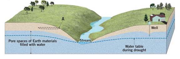
Describe the shape of the water table in relationship to the shape of the land surface.
Expert Solution & Answer

Learn your wayIncludes step-by-step video

schedule08:31
Students have asked these similar questions
Describe what the wind power as an energy source is. Describe 5 advantages of wind power as an energy source. Describe 5 disadvantages of wind power as an energy source. Discuss the future potential wind power as an energy source in the United States. Describe how you would convince the residents of the State of Connecticut to utilize more wind power as an energy source
How is the biofuel ethanol produced?
Distinguish between reserves and resoirces
Chapter 8 Solutions
Applications and Investigations in Earth Science Plus Mastering Geology with Pearson eText -- Access Card Package (9th Edition) (What's New in Geosciences)
Ch. 8.1 - Sketch, label, and discuss the hydrologic cycle....Ch. 8.1 - Sketch, label, and discuss the hydrologic cycle....Ch. 8.1 - Sketch, label, and discuss the hydrologic cycle....Ch. 8.1 - Sketch, label, and discuss the hydrologic cycle....Ch. 8.1 - Sketch, label, and discuss the hydrologic cycle....Ch. 8.1 - Label the drawing in Figure 8.2 with the letters...Ch. 8.2 - Of the three materials you tested coarse sand,...Ch. 8.2 - Prob. 2ACh. 8.2 - Prob. 3ACh. 8.2 - Prob. 4A
Ch. 8.3 - Does urbanization increase or decrease the peak...Ch. 8.3 - What is the effect of urbanization on lag time the...Ch. 8.3 - Does total runoff occur over a longer or shorter...Ch. 8.3 - Based on what you have learned from the...Ch. 8.4A - Compare the stereogram in Figure 8.7 to the map in...Ch. 8.4A - Is the terrain in section 14, located on the west...Ch. 8.4A - Label the areas that topographically resemble...Ch. 8.4A - Describe the topography in the lower half of...Ch. 8.4A - Section 17 contains a portion of the valley...Ch. 8.4A - Which of the following best describes the shape of...Ch. 8.4A - Calculate the gradient, or slope, of this portion...Ch. 8.4A - Approximately how many feet is the Missouri River...Ch. 8.4A - What are the features in the river labeled with...Ch. 8.4A - Based on your answer to Question 9, are the...Ch. 8.4A - Over time, as tributaries erode and lengthen their...Ch. 8.4B - Draw an arrow on the map to indicate the direction...Ch. 8.4B - Use the BM elevations from Question 1 to calculate...Ch. 8.4B - Approximately how many feet is the Genesee River...Ch. 8.4B - The path of the Genesee River can best be...Ch. 8.4B - Which phrase most accurately describes most of the...Ch. 8.4B - Use the fractional scales on the Angelica...Ch. 8.4C - Approximately what percentage of the map area is...Ch. 8.4C - Prob. 2ACh. 8.4C - Prob. 3ACh. 8.4C - Prob. 4ACh. 8.4C - Prob. 5ACh. 8.4C - Write a statement that compares the width of the...Ch. 8.4C - Is the Red River actively downcutting its channel...Ch. 8.4C - On which of the three maps is the gradient of the...Ch. 8.4C - Choosing from Figure 8.6, Figure 8.8, or Figure...Ch. 8.5 - Label the zone of saturation, the unsaturated...Ch. 8.5 - Describe the shape of the water table in...Ch. 8.5 - Whenever a substantial amount of water is...Ch. 8.5 - Use a pencil to shade the area between the dashed...Ch. 8.5 - How does the drop in the water table during a...Ch. 8.6 - Calculate the elevation of the water table at each...Ch. 8.6 - Assume that a dye was put into well A on May 10,...Ch. 8.7 - What is the general relationship between ground...Ch. 8.7 - What was the total ground subsidence, and what was...Ch. 8.7 - During the period shown on the graph, on average,...Ch. 8.7 - Was the ground subsidence that occurred between...Ch. 8.7 - Notice that minimal subsidence occurred from 1935...Ch. 8.8 - Locate three sinkholes depressions on the map and...Ch. 8.8 - Notice that several sinkholes have water in them....Ch. 8.8 - Describe what is happening to Gardner Creek in the...Ch. 8 - Write a statement or two describing the movement...Ch. 8 - Assume that you need to determine the rate at...Ch. 8 - Write a brief paragraph summarizing the results of...Ch. 8 - The diagrams in Figure 8.20 show lag time between...Ch. 8 - On Figure 8.21, identify and label as many...Ch. 8 - Name and describe two features you would expect to...Ch. 8 - On Figure 8.22, identify and label as many...Ch. 8 - Assume that you have decided to drill a water...Ch. 8 - Name and describe two features you would expect to...
Additional Science Textbook Solutions
Find more solutions based on key concepts
5. A boy flies a kite with the string at a 30° angle to the horizontal. The tension in the string is 4.5 N. How...
College Physics: A Strategic Approach (3rd Edition)
Color of alizarin yellow when dissolved in water needs to be explained. Concept Introduction: The concepts of L...
Living By Chemistry: First Edition Textbook
Explain all answers clearly, with complete sentences and proper essay structure if needed. An asterisk (*) desi...
Cosmic Perspective Fundamentals
If someone at the other end of a room smokes a cigarette, you may breathe in some smoke. The movement of smoke ...
Campbell Essential Biology with Physiology (5th Edition)
What are the four types of tissues, and what are their characteristics?
Human Anatomy & Physiology (2nd Edition)
All of the following terms can appropriately describe humans except: a. primary consumer b. autotroph c. hetero...
Human Biology: Concepts and Current Issues (8th Edition)
Knowledge Booster

Similar questions
- Describe what kind of energy source oil ia. Describe 5 advantages of oil as an energy source. Describe 5 disadvantages of oil as energy source. Discuss the future potential of oil as energy source in the United States. Describe how you would convince the residents of the State of Connecticut to utilize more oil as an energy source.arrow_forwardWhat are negative environmental impacts of developing hydroelectric power?arrow_forwardList three negative environmental impacts of using biomass to provide energy.arrow_forward
- 1. Use the elevations in Figure 7.12 as a guide for drawing contour lines. The 100-foot contour line is provided for reference. Using a 20-foot contour interval, draw a contour line for each 20-foot change in elevation below and above 100 feet (e.g., 60 feet, 80 feet, 120 feet). You will have to estimate the elevations between the points. Label each contour line with its elevation. 2. Does the land shown on the topographic map you constructed generally slope downward toward the north or south? 3. Show the direction each stream is flowing by drawing arrows on the map.arrow_forwardDrawing a Topographic Profile Follow the steps illustrated in Figure 7.13 to draw a topographic profile. Use the profile graph in Figure 7.14 to construct a west-east profile along the line A-A' on the contour map you completed in Figure 7.12. Step 1. Our sample profile will be along line A-A. When constructing profiles on maps provided by your instructor, do not draw on the map. Step 2. Lay a piece of paper along the line of the profile you want to construct. In this example this is line A-A'. Mark each place where a contour line intersects the edge of the paper and note the elevation of the contour line. Step 3. On a separate piece of paper, draw a horizontal line slightly longer than your profile line, A-A'. Select a vertical scale for your profile that begins slightly. below the lowest elevation along the profile and extends slightly beyond the highest elevation. Mark this scale on either side of the horizontal line. Lay the marked paper edge (from Step 2) along the horizontal…arrow_forwardWhen contour lines cross streams or dry stream channels, they form a V that points upstream. Draw arrows next to three of the streams (shown in blue) to indicate the direction in which each is flowing.arrow_forward
- Coal-burning electric power plants in the Pa Midwest have contributed to acid rain in the eastern United States. Other energy sources would most likely be costlier than coal, thereby raising electricity rates. Should citizens in eastern states be able to pressure utility companies in the Midwest to change their method of generating electricity? What mechanisms might be available to make these changes? How effective are these mechanisms?arrow_forwardWhat renewable energy source provides the majority of renewable energy?arrow_forwardWhat are the general characteristics of renewable energy sources?arrow_forward
arrow_back_ios
SEE MORE QUESTIONS
arrow_forward_ios
Recommended textbooks for you
 Applications and Investigations in Earth Science ...Earth ScienceISBN:9780134746241Author:Edward J. Tarbuck, Frederick K. Lutgens, Dennis G. TasaPublisher:PEARSON
 Exercises for Weather & Climate (9th Edition)Earth ScienceISBN:9780134041360Author:Greg CarbonePublisher:PEARSON
 Environmental ScienceEarth ScienceISBN:9781260153125Author:William P Cunningham Prof., Mary Ann Cunningham ProfessorPublisher:McGraw-Hill Education
 Earth Science (15th Edition)Earth ScienceISBN:9780134543536Author:Edward J. Tarbuck, Frederick K. Lutgens, Dennis G. TasaPublisher:PEARSON
 Environmental Science (MindTap Course List)Earth ScienceISBN:9781337569613Author:G. Tyler Miller, Scott SpoolmanPublisher:Cengage Learning
 Physical GeologyEarth ScienceISBN:9781259916823Author:Plummer, Charles C., CARLSON, Diane H., Hammersley, LisaPublisher:Mcgraw-hill Education,
Applications and Investigations in Earth Science ...
Earth Science
ISBN:9780134746241
Author:Edward J. Tarbuck, Frederick K. Lutgens, Dennis G. Tasa
Publisher:PEARSON
Exercises for Weather & Climate (9th Edition)
Earth Science
ISBN:9780134041360
Author:Greg Carbone
Publisher:PEARSON
Environmental Science
Earth Science
ISBN:9781260153125
Author:William P Cunningham Prof., Mary Ann Cunningham Professor
Publisher:McGraw-Hill Education
Earth Science (15th Edition)
Earth Science
ISBN:9780134543536
Author:Edward J. Tarbuck, Frederick K. Lutgens, Dennis G. Tasa
Publisher:PEARSON
Environmental Science (MindTap Course List)
Earth Science
ISBN:9781337569613
Author:G. Tyler Miller, Scott Spoolman
Publisher:Cengage Learning
Physical Geology
Earth Science
ISBN:9781259916823
Author:Plummer, Charles C., CARLSON, Diane H., Hammersley, Lisa
Publisher:Mcgraw-hill Education,