Using Figure 8-2:
- a. Circle the area with the greatest pressure gradient.
- b. Use arrows to show the direction of pressure gradient force at a few locations. (These are typically drawn perpendicular to isobars.)
- c. Label a region where you would expect the lightest winds.
(a)
The area with the greatest pressure gradient in Figure 8-2 using circle.
Answer to Problem 1E
The map showing the area with the greatest pressure gradient is given below:
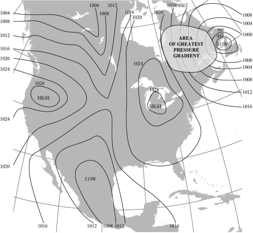
Explanation of Solution
“The magnitude of pressure gradient force is a function of the pressure difference between two points and air density.”
The map given in Figure 8-2 shows isobars, which are lines that connect areas with equal pressure. Closer isobars represent areas with higher pressure gradient. On the basis of this, the greatest pressure gradient is marked using a circle in the map towards the top right side of the Figure.
(b)
The direction of pressure gradient force at some locations in Figure 8-2 using arrows.
Answer to Problem 1E
The map with the direction of pressure gradient force at some locations indicated using arrows is shown below:
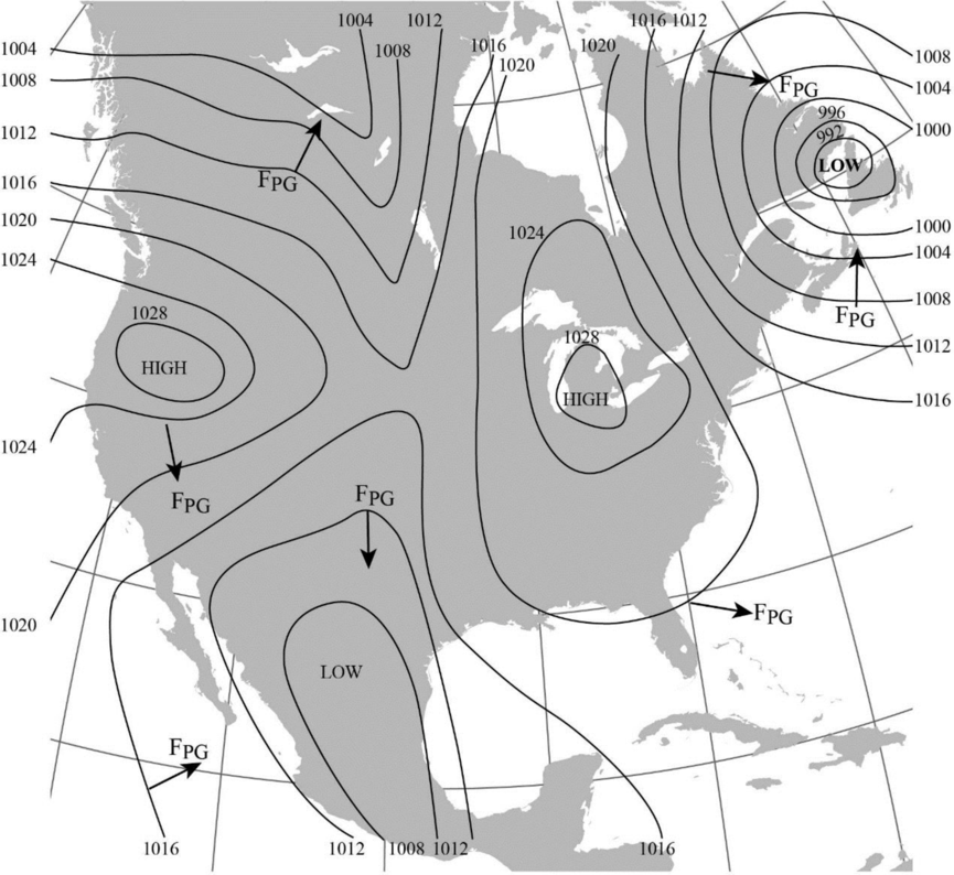
Explanation of Solution
The direction of pressure gradient force is usually drawn perpendicular to the isobars. The pressure gradient force is generally directed from the region of high pressure to lower pressure.
(c)
The region where the lightest winds are expected to occur in Figure 8-2.
Answer to Problem 1E
The area expected to experience the lightest winds is labelled in the map given below:
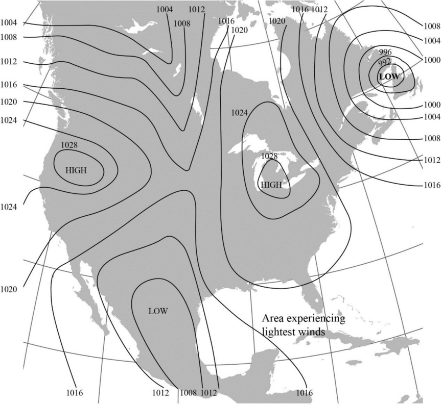
Explanation of Solution
The isobars that are widely-spaced generally denote a gradual pressure gradient and lighter winds whereas the closely-spaced isobars denote steep pressure gradient and stronger winds.
Want to see more full solutions like this?
Chapter 8 Solutions
Exercises for Weather & Climate (9th Edition)
Additional Science Textbook Solutions
Introductory Chemistry (6th Edition)
Campbell Biology in Focus (2nd Edition)
Organic Chemistry (8th Edition)
Campbell Biology (11th Edition)
Microbiology: An Introduction
Chemistry: An Introduction to General, Organic, and Biological Chemistry (13th Edition)

- 6) Just 15% of global evaporation occurs over the continents even though the continents cover about 29% of the earth’s surface. Why is the proportion of global evaporation that occurs on continents less than 29%?arrow_forwardWhat are the four elements of a local water budget ? Assuming all else is held equal, what is the effect of warming on the atmosphere’s ability to evaporate water from soils and vegetation? What happens to the amount of water stored in the soil if warming affects evapotranspiration in the way you described above and there is no change to runoff?arrow_forwardThe map below shows the age of the ocean floor (time since the crust was formed). Why do we find the youngest ocean crust at the mid-ocean ridges? Why does the oldest crust tend to be near continental coasts?arrow_forward
- what is a main piece of evidence that the continents were once all connected in a single super continent 200–300 million years ago? What was the main role of plate tectonics in breaking up this super continentarrow_forwardWhat might occur when humans overuse the natural resources of a space or habitat? Question 2 options: Environmental Stability Species Extinction Resource Regeneration Ecological Deficitarrow_forwardWhat does natural capital include? Question 3 options: Water, Land, Air Renewable resources Non-renewable resources Culture heritagearrow_forward
- Natural Gas is a renewable natural resource. Question 1 options: True Falsearrow_forwardPlease help as soon as possible. I have an answer for this, but I'm a bit confused, so any extra assistance would be appreciated! Complete the cross sections on the front and side of the block diagram in Figure 6.6. Complete the cross-section of the side of the block diagram in Figure 6.7. Complete the front and side of the block diagram in Figure 6.8arrow_forwarda. Draw four sedimentary layers of equal thickness that have a strike of N90°E. (Hint: Sketch the map view first.)b. Each layer is dipping to the south at an angle of 60°.c. On the block diagram complete the map view and both cross-sectional views.d. Add strike-dip symbols for each rock layer on both parts of Figure 6.9.arrow_forward
- There is an old axiom (a self-evident or universally recognized truth) of economics that “There is no such thing as a free lunch”. In the United States, stringent, enforced water quality laws and regulations provide a high level of protection of our waters. This is accomplished at a significant cost. For example, (sewage treatment plants use 2% of the electricity produced in the United States. This high level of protection increases the cost of goods manufactured in the United States compared to other nations such as China where standards are lower, enforcement a bit lax and in some cases, non-existent. What five (5) things could be done to “level the playing field” so that all manufacturers must provide the same degree of water quality protection no matter where in the world they are located? include how each of your ideas will be implemented (ex: which organization will be provided the power and resources to make sure each idea happens). These should be only about water pollution,…arrow_forwardConnecticut is the only state in America where treated industrial and municipal wastewater cannot be discharged to a surface water body used downstream as a source of drinking water. It is legal in all 49 other states. For example, New Orleans, Louisiana takes its drinking water from the Mississippi River which receives discharges of many, many treated municipal and industrial wastewater discharges as well as agricultural runoff from the more than 20 states that are upstream of it. Should other states be required to adopt Connecticut's standard? Whyarrow_forwardWhat is thermal pollution? How can it be controlled?arrow_forward
 Applications and Investigations in Earth Science ...Earth ScienceISBN:9780134746241Author:Edward J. Tarbuck, Frederick K. Lutgens, Dennis G. TasaPublisher:PEARSON
 Exercises for Weather & Climate (9th Edition)Earth ScienceISBN:9780134041360Author:Greg CarbonePublisher:PEARSON
 Environmental ScienceEarth ScienceISBN:9781260153125Author:William P Cunningham Prof., Mary Ann Cunningham ProfessorPublisher:McGraw-Hill Education
 Earth Science (15th Edition)Earth ScienceISBN:9780134543536Author:Edward J. Tarbuck, Frederick K. Lutgens, Dennis G. TasaPublisher:PEARSON
 Environmental Science (MindTap Course List)Earth ScienceISBN:9781337569613Author:G. Tyler Miller, Scott SpoolmanPublisher:Cengage Learning
 Physical GeologyEarth ScienceISBN:9781259916823Author:Plummer, Charles C., CARLSON, Diane H., Hammersley, LisaPublisher:Mcgraw-hill Education,