
APPS & INV IN EARTH SCIENCE, LAB MANUAL
9th Edition
ISBN: 9780135943601
Author: Lutgens
Publisher: PEARSON
expand_more
expand_more
format_list_bulleted
Textbook Question
Chapter 7, Problem 2LR
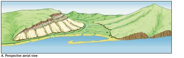
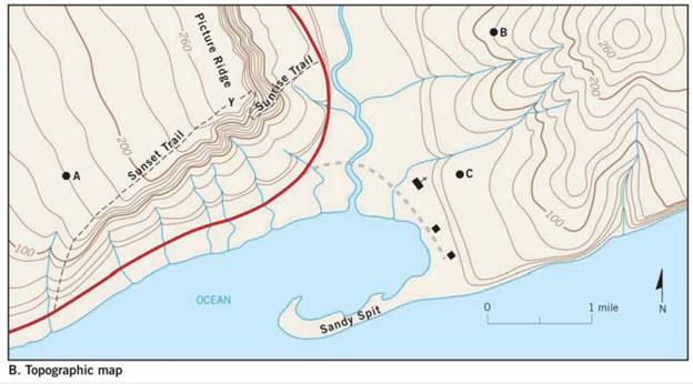
List the elevations of each index contour on the map.![]()
Expert Solution & Answer

Learn your wayIncludes step-by-step video

schedule08:33
Students have asked these similar questions
Compare a passive solar heating system with an active solar heating system.
Describe what the wind power as an energy source is. Describe 5 advantages of wind power as an energy source. Describe 5 disadvantages of wind power as an energy source. Discuss the future potential wind power as an energy source in the United States. Describe how you would convince the residents of the State of Connecticut to utilize more wind power as an energy source
How is the biofuel ethanol produced?
Chapter 7 Solutions
APPS & INV IN EARTH SCIENCE, LAB MANUAL
Ch. 7.1 - Obtain a stereoscope from your instructor, unfold...Ch. 7.1 - Prob. 2ACh. 7.1 - Prob. 3ACh. 7.1 - Prob. 4ACh. 7.2 - Prob. 1ACh. 7.2 - Prob. 2ACh. 7.3 - Prob. 1ACh. 7.3 - Prob. 3ACh. 7.3 - Prob. 6ACh. 7.4 - Depending on the map scale, 1 inch on a...
Ch. 7.4 - Examine Figure 7.6 and complete the map...Ch. 7.6 - The difference in elevation between adjacent...Ch. 7.6 - What is the difference in elevation between Points...Ch. 7.6 - Notice that every fifth contour line, called an...Ch. 7.6 - Prob. 4ACh. 7.6 - One or more roughly circular closed contours...Ch. 7.6 - Closed contours with hachures short lines that...Ch. 7.6 - When contour lines cross streams or dry stream...Ch. 7.6 - Estimating the elevations of places not located on...Ch. 7.6 - Relief is defined as the difference in elevation...Ch. 7.7 - Use the elevations in Figure 7.12 as a guide for...Ch. 7.7 - Does the land shown on the topographic map you...Ch. 7.7 - Use the profile graph in Figure 7.14 to construct...Ch. 7.8 - Use the profile graph in Figure 7.14 to construct...Ch. 7.9 - What is the contour interval of this map?Ch. 7.9 - What is the difference in elevation from one index...Ch. 7.9 - Prob. 3ACh. 7.9 - Locate the small intermittent stream blue dashed...Ch. 7.9 - What is the approximate elevation of the point...Ch. 7.9 - What is the approximate relief between point X and...Ch. 7.9 - Which of the following phrases best describes the...Ch. 7.9 - The area on both sides of Tennessee Creek in...Ch. 7.9 - Describe the change in elevation you would...Ch. 7.9 - What is the elevation of the town of Leadville,...Ch. 7.9 - Prob. 11ACh. 7 - Determine the contour interval used on this map...Ch. 7 - List the elevations of each index contour on the...Ch. 7 - What are the elevations of the locations...Ch. 7 - What is the elevation of the church? Elevation of...Ch. 7 - Indicate two areas on this map that have steep...Ch. 7 - Describe the relief of Sandy Spit with one of the...Ch. 7 - Mark the top of the hill in the northeast corner...Ch. 7 - Is the top of Picture Ridge, designated Y, at a...Ch. 7 - What is the maximum relief shown on this contour...Ch. 7 - Imagine that you are taking a group of friends...Ch. 7 - Use the satellite images in figure 7.17, which...
Additional Science Textbook Solutions
Find more solutions based on key concepts
Label the area covered by ground moraine.
Applications and Investigations in Earth Science (9th Edition)
3. Which of the following is a major functional characteristic of all organisms? (a) movement, (b) growth (c) m...
Human Anatomy & Physiology (Marieb, Human Anatomy & Physiology) Standalone Book
2. Whether an allele is dominant or recessive depends on
a. how common the allele is, relative to other alleles...
Campbell Biology: Concepts & Connections (9th Edition)
What is the difference between cellular respiration and external respiration?
Human Physiology: An Integrated Approach (8th Edition)
Why are the top predators in food chains most severely affected by pesticides such as DDT?
Campbell Essential Biology with Physiology (5th Edition)
Thiols such as ethanethiol and propanethiol can be used to reduce vitamin K epoxide to vitamin KH2, but they re...
Organic Chemistry (8th Edition)
Knowledge Booster

Similar questions
- Distinguish between reserves and resoircesarrow_forwardDescribe what kind of energy source oil ia. Describe 5 advantages of oil as an energy source. Describe 5 disadvantages of oil as energy source. Discuss the future potential of oil as energy source in the United States. Describe how you would convince the residents of the State of Connecticut to utilize more oil as an energy source.arrow_forwardWhat are negative environmental impacts of developing hydroelectric power?arrow_forward
- List 3 energy conservation tecniquesarrow_forward1. Use the elevations in Figure 7.12 as a guide for drawing contour lines. The 100-foot contour line is provided for reference. Using a 20-foot contour interval, draw a contour line for each 20-foot change in elevation below and above 100 feet (e.g., 60 feet, 80 feet, 120 feet). You will have to estimate the elevations between the points. Label each contour line with its elevation. 2. Does the land shown on the topographic map you constructed generally slope downward toward the north or south? 3. Show the direction each stream is flowing by drawing arrows on the map.arrow_forwardDrawing a Topographic Profile Follow the steps illustrated in Figure 7.13 to draw a topographic profile. Use the profile graph in Figure 7.14 to construct a west-east profile along the line A-A' on the contour map you completed in Figure 7.12. Step 1. Our sample profile will be along line A-A. When constructing profiles on maps provided by your instructor, do not draw on the map. Step 2. Lay a piece of paper along the line of the profile you want to construct. In this example this is line A-A'. Mark each place where a contour line intersects the edge of the paper and note the elevation of the contour line. Step 3. On a separate piece of paper, draw a horizontal line slightly longer than your profile line, A-A'. Select a vertical scale for your profile that begins slightly. below the lowest elevation along the profile and extends slightly beyond the highest elevation. Mark this scale on either side of the horizontal line. Lay the marked paper edge (from Step 2) along the horizontal…arrow_forward
- When contour lines cross streams or dry stream channels, they form a V that points upstream. Draw arrows next to three of the streams (shown in blue) to indicate the direction in which each is flowing.arrow_forwardCoal-burning electric power plants in the Pa Midwest have contributed to acid rain in the eastern United States. Other energy sources would most likely be costlier than coal, thereby raising electricity rates. Should citizens in eastern states be able to pressure utility companies in the Midwest to change their method of generating electricity? What mechanisms might be available to make these changes? How effective are these mechanisms?arrow_forwardWhat renewable energy source provides the majority of renewable energy?arrow_forward
arrow_back_ios
SEE MORE QUESTIONS
arrow_forward_ios
Recommended textbooks for you
 Applications and Investigations in Earth Science ...Earth ScienceISBN:9780134746241Author:Edward J. Tarbuck, Frederick K. Lutgens, Dennis G. TasaPublisher:PEARSON
 Exercises for Weather & Climate (9th Edition)Earth ScienceISBN:9780134041360Author:Greg CarbonePublisher:PEARSON
 Environmental ScienceEarth ScienceISBN:9781260153125Author:William P Cunningham Prof., Mary Ann Cunningham ProfessorPublisher:McGraw-Hill Education
 Earth Science (15th Edition)Earth ScienceISBN:9780134543536Author:Edward J. Tarbuck, Frederick K. Lutgens, Dennis G. TasaPublisher:PEARSON
 Environmental Science (MindTap Course List)Earth ScienceISBN:9781337569613Author:G. Tyler Miller, Scott SpoolmanPublisher:Cengage Learning
 Physical GeologyEarth ScienceISBN:9781259916823Author:Plummer, Charles C., CARLSON, Diane H., Hammersley, LisaPublisher:Mcgraw-hill Education,
Applications and Investigations in Earth Science ...
Earth Science
ISBN:9780134746241
Author:Edward J. Tarbuck, Frederick K. Lutgens, Dennis G. Tasa
Publisher:PEARSON
Exercises for Weather & Climate (9th Edition)
Earth Science
ISBN:9780134041360
Author:Greg Carbone
Publisher:PEARSON
Environmental Science
Earth Science
ISBN:9781260153125
Author:William P Cunningham Prof., Mary Ann Cunningham Professor
Publisher:McGraw-Hill Education
Earth Science (15th Edition)
Earth Science
ISBN:9780134543536
Author:Edward J. Tarbuck, Frederick K. Lutgens, Dennis G. Tasa
Publisher:PEARSON
Environmental Science (MindTap Course List)
Earth Science
ISBN:9781337569613
Author:G. Tyler Miller, Scott Spoolman
Publisher:Cengage Learning
Physical Geology
Earth Science
ISBN:9781259916823
Author:Plummer, Charles C., CARLSON, Diane H., Hammersley, Lisa
Publisher:Mcgraw-hill Education,