Determine the contour interval used on this map
Contour interval:_________________ feet.
![]()
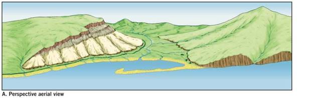
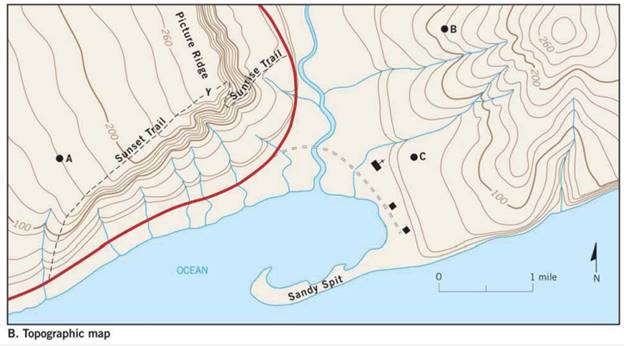
The counter interval used on the given topographic map of a hypothetical area.
Introduction:
Topographic maps represent large scale structures of the Earth surface such as hills, streams, and valley. The contour interval is defined as the difference in the vertical elevation between the adjacent contour lines.
Explanation of Solution
Contour interval is calculated by the given formula:
The difference in elevation from the given map is calculated as:
Number of contour lines are 5
Therefore, by substituting the following values in equation (I),
Hence, the counter interval used on the given map is 20 feet.
Want to see more full solutions like this?
Chapter 7 Solutions
Applications and Investigations in Earth Science Plus Mastering Geology with Pearson eText -- Access Card Package (9th Edition) (What's New in Geosciences)
Additional Science Textbook Solutions
Brock Biology of Microorganisms (15th Edition)
Applications and Investigations in Earth Science (9th Edition)
Human Anatomy & Physiology (2nd Edition)
Campbell Essential Biology (7th Edition)
Campbell Biology (11th Edition)
Living By Chemistry: First Edition Textbook

- For the past 3 million years the earth has experienced glacial-interglacial cycles at regular intervals that coincide with the Milankovitch Cycles. Please briefly describe the three Milankovitch Cycles and their timescales. What is the leading theory for why the timing of glacial-interglacial cycles is connected to these Milankovitch Cycles?arrow_forwardWhy do waterfalls move backwards over time? In your explanation, please use the term “nickpoint”?arrow_forwardThe picture below is of the Kaskawulsh Glacier in Yukon, Canada. What is the name of the type of feature that the red arrows are pointing to in the middle of the glacier and how are these features formed? In your answer please also define the term lateral moraine and how lateral moraines relate to the feature with the red arrows?arrow_forward
- it was stated that one major effect of rivers is to flatten out the continents. How do rivers flatten continents?arrow_forwardThe figure below shows the average change in glacier mass per unit area for various mountainous regions around the world. Why are the globe’s mountain glaciers shrinking? Does glacial melt increase or decrease the amount of water stored on the continents? What are the factors in the continental water budget equation that must change in order to restore equilibrium when glaciers melt ? What is the effect on global sea level?arrow_forwardWhat is continental precipitation recycling ?Using the concept of precipitation, please explain why changes in landcover in one place can feed back to impact the climate not only in the area where the landcover change occurred but also in other regions?arrow_forward
- In the western United States, does severe forest fire tend to increase or decrease streamflow? What are the two main reasons hypothesized to cause this effect?arrow_forwardForest-fire sizes in the western US have grown rapidly in recent decades. made the case that this was not due to increased human population and resultant human-caused ignitions. What was the main evidence for this?arrow_forwardDraw a cross section with a tree growing out of Earth’s surface (so I know which side is the surface). Add a dipping joint and label the hanging wall and footwall blocks. Draw a second cross section (again with a tree on the surface of the Earth) that shows how Earth’s surface would be offset along this joint if it turned into a normal fault. Label the hanging wall and footwall and use arrows to indicate the motion of the hanging wall relative to the footwall. Now draw a third cross section with all the same elements as in parts A and B, but for a trust/reverse fault. Imagine the same cross section either in three dimensions, or in a bird’s-eye view from top down. Draw what this area would look like after a right-lateral strike-slip fault. Label the strike of the fault and use arrows to show directions of movementarrow_forward
- Examine the strike and dip of the rock units on the Devil's Fence geologic map in Figure 6.21. Draw multiple large arrows on the map, pointing in the direction of dip on several rock units. Do the rock layers located near the center of the map in Section 14 dip toward the northwest or southeast? The same rocks in Section 14 are also found in Section 18. Do the rocks in Section 18 dip toward the east or west? What is the approximate angle of dip of the units in Section 18?arrow_forward1. Draw a dashed line representing the hinge line of the large geologic structure that occupies most of the map. Label the hinge line. 2. Are the rocks getting older or younger farther from the hinge line? 3. Is this geologic structure a plunging anticline or syncline? 4. Provide two lines of evidence that support your answer to Question 8.arrow_forwardOn the map in Figure 6.21, write the word oldest where the oldest sedimentary rock unit is exposed at the sur-face and the word youngest where the youngest sedimentary rocks occur.arrow_forward
 Applications and Investigations in Earth Science ...Earth ScienceISBN:9780134746241Author:Edward J. Tarbuck, Frederick K. Lutgens, Dennis G. TasaPublisher:PEARSON
 Exercises for Weather & Climate (9th Edition)Earth ScienceISBN:9780134041360Author:Greg CarbonePublisher:PEARSON
 Environmental ScienceEarth ScienceISBN:9781260153125Author:William P Cunningham Prof., Mary Ann Cunningham ProfessorPublisher:McGraw-Hill Education
 Earth Science (15th Edition)Earth ScienceISBN:9780134543536Author:Edward J. Tarbuck, Frederick K. Lutgens, Dennis G. TasaPublisher:PEARSON
 Environmental Science (MindTap Course List)Earth ScienceISBN:9781337569613Author:G. Tyler Miller, Scott SpoolmanPublisher:Cengage Learning
 Physical GeologyEarth ScienceISBN:9781259916823Author:Plummer, Charles C., CARLSON, Diane H., Hammersley, LisaPublisher:Mcgraw-hill Education,