Sketch, label, and discuss the hydrologic cycle.
Earth's water is constantly moving between Earth's surface and atmosphere. The hydrologic cycle describes the continuous movement of water from the oceans to the atmosphere, from the atmosphere to the land, and from the land back to the sea Over most of Earth, the Quantity of precipitation that falls on the land must eventually be accounted for by the sum total of evaporation, transpiration (the release water vapor by vegetation), runoff, and infiltration
A portion of the precipitation that falls on land will soak into the ground through a process called infiltration. If the rate of rainfall exceeds the ability of the surface to absorb it, the additional water flows over the surface and becomes runoff. Runoff initially flows in broad sheets that form tiny channels called rills The rills merge to form gullies, which eventually join to create streams erosion by both groundwater and running water wears down the land and shapes Earth's surface
Figure 8.1 illustrates Earth's water balance, a quantitative view of the hydrologic cycle The figure Implies a globally uniform exchange of water between Earth's atmosphere and surface, but factors such as climate, steepness of slope, surface materials, vegetation, and degree of urbanization produce local variations
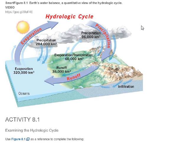
Worldwide, about how much of the precIpitation that falls on the land becomes runoff 35, 55, or 75 percent?
About ________ % becomes runoff

Learn your wayIncludes step-by-step video

Chapter 4 Solutions
Applications and Investigations in Earth Science (8th Edition)
Additional Science Textbook Solutions
Biochemistry: Concepts and Connections (2nd Edition)
Biology: Life on Earth with Physiology (11th Edition)
Campbell Essential Biology (7th Edition)
Chemistry & Chemical Reactivity
Campbell Essential Biology with Physiology (5th Edition)
Human Biology: Concepts and Current Issues (8th Edition)

- Discussion Question: Tectonics, Earthquakes and Volcanism A+ The image below can also be found in your textbook. This image is not an interpretation but an actual picture of the Red Sea. This area of the world is the East African Rift Zone separating Saudi Arabia and Africa. The linear pattern is due to extensional tectonics. In other words, Africa and Saudi Arabia are moving away from each other creating tensional forces that create normal faults. The landscape features found in the area are Rift Valleys. Pretend we are on location at the East African Rift Valley. We would find Normal Faults where one side of the fault shows a rock layer dropped relative to the other layer. We would find linear mountains that formed from the valley dropping out between the normal faults. The microscale evidence we collect helps to add up to the macroscale interpretation of a divergent boundary due to tensional forces creating normal faults and rift valleys.arrow_forwardPlease explain why low clouds occur off of California’s coast during summer. In your explanation, please include the terms “Hadley Circulation,” “atmospheric subsidence,” and “ocean upwelling''arrow_forwardIn Sequoia National Park, why does soil moisture increase in April even though precipitation totals are on average lower in April than in March?arrow_forward
- The continents are net importers of precipitation from the oceans. We know this because, while only 15% of global evaporation occurs from the continents, the continents receive 23% of the globe’s precipitation. How is this discrepancy sustainable without the continents filling up with water and the oceans emptying out?arrow_forward6) Just 15% of global evaporation occurs over the continents even though the continents cover about 29% of the earth’s surface. Why is the proportion of global evaporation that occurs on continents less than 29%?arrow_forwardWhat are the four elements of a local water budget ? Assuming all else is held equal, what is the effect of warming on the atmosphere’s ability to evaporate water from soils and vegetation? What happens to the amount of water stored in the soil if warming affects evapotranspiration in the way you described above and there is no change to runoff?arrow_forward
- The map below shows the age of the ocean floor (time since the crust was formed). Why do we find the youngest ocean crust at the mid-ocean ridges? Why does the oldest crust tend to be near continental coasts?arrow_forwardwhat is a main piece of evidence that the continents were once all connected in a single super continent 200–300 million years ago? What was the main role of plate tectonics in breaking up this super continentarrow_forwardWhat might occur when humans overuse the natural resources of a space or habitat? Question 2 options: Environmental Stability Species Extinction Resource Regeneration Ecological Deficitarrow_forward
- What does natural capital include? Question 3 options: Water, Land, Air Renewable resources Non-renewable resources Culture heritagearrow_forwardNatural Gas is a renewable natural resource. Question 1 options: True Falsearrow_forwardPlease help as soon as possible. I have an answer for this, but I'm a bit confused, so any extra assistance would be appreciated! Complete the cross sections on the front and side of the block diagram in Figure 6.6. Complete the cross-section of the side of the block diagram in Figure 6.7. Complete the front and side of the block diagram in Figure 6.8arrow_forward
 Applications and Investigations in Earth Science ...Earth ScienceISBN:9780134746241Author:Edward J. Tarbuck, Frederick K. Lutgens, Dennis G. TasaPublisher:PEARSON
 Exercises for Weather & Climate (9th Edition)Earth ScienceISBN:9780134041360Author:Greg CarbonePublisher:PEARSON
 Environmental ScienceEarth ScienceISBN:9781260153125Author:William P Cunningham Prof., Mary Ann Cunningham ProfessorPublisher:McGraw-Hill Education
 Earth Science (15th Edition)Earth ScienceISBN:9780134543536Author:Edward J. Tarbuck, Frederick K. Lutgens, Dennis G. TasaPublisher:PEARSON
 Environmental Science (MindTap Course List)Earth ScienceISBN:9781337569613Author:G. Tyler Miller, Scott SpoolmanPublisher:Cengage Learning
 Physical GeologyEarth ScienceISBN:9781259916823Author:Plummer, Charles C., CARLSON, Diane H., Hammersley, LisaPublisher:Mcgraw-hill Education,