To draw:
The Earth’s grid system, including equator and prime meridian and also description of the system used to locate points on Earth’s surface.
Introduction:
The maps and globes display the system of east-west, and north-south lines, which is described as the Earth’s grid.
Explanation of Solution
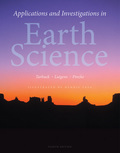
Pictorial representation: Figure 1 represents the Earth’s grid system.
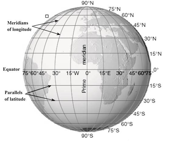
Fig. 1: Earth’s grid system
The north-south lines in figure 1 represent parallels of latitude, and the east-west lines represent meridians of longitude. The Earth’s grid system generates the basis for locating the points on the surface of Earth. The position of a specific point can be determined by the intersection of two lines. At prime meridian, the longitude is described as 0°. The location of a point is measured in degrees west and east of prime meridian from 0° to 180°.
Want to see more full solutions like this?
Chapter 22 Solutions
EBK APPLICATIONS AND INVESTIGATIONS IN

- Name three advantages of using GIS toolsarrow_forward9. In fieldwork-based research, which of the following involves the use of on-site instruments but would be less appropriate for low-frequency events like landslides or extreme floods? a. an ergodic approach b. environmental monitoring c. sampling across spacearrow_forward7. _ The climate-change scientist Mike Hulme has argued that people who tend to see nature as tolerant, and who believe that global climate properties would likely respond very favourably to certain planetary geo-engineering solutions, tend to be: a. egalitarians. b. hierarchists. c. individualists.arrow_forward
- Cronon’s Research on Wilderness – Consider Cronon’s study of wilderness, as discussed by Kanazawa (2023). In what ways, if any, would it have been appropriate for Cronon to have used quantitative methods in his study of the concept of wilderness, and to what end? Why were qualitative methods particularly appropriate for the study, given the nature of his research topic? 150-200 words response to the questionarrow_forwardConsider Cronon’s study of wilderness, as discussed by Kanazawa (2023). In what ways, if any, would it have been appropriate for Cronon to have used quantitative methods in his study of the concept of wilderness, and to what end? Why were qualitative methods particularly appropriate for the study, given the nature of his research topic?arrow_forwardWhy might drought actually cause fire risk to reduce in a desert area?arrow_forward
- Part 1: A completely saturated sample of sandstone has a bulk density of 2.61 g/cm³, an effective porosity of 10 percent, and a total porosity of 12 percent. Determine the density of the solid phase (i.e., the density of the mineral). Part 2: One cubic meter of quartz sand has a dry mass of 2,320 kg. a) Calculate the porosity of the sand. b) Calculate the mass (in kg) of the sand for the following degrees of saturation: 25 percent, 75 percent, 100 percent. Part 3: A sample of quartz sand has a dry mass of 753.7 kg and a volume of 0.36 m³. a) Calculate the porosity of the sand. b) Calculate the mass (in kg) of the sand assuming a degree of saturation equal to 62 percent.arrow_forwardWhat is an oxbow lake and how is it formed?arrow_forwardFor the past 3 million years the earth has experienced glacial-interglacial cycles at regular intervals that coincide with the Milankovitch Cycles. Please briefly describe the three Milankovitch Cycles and their timescales. What is the leading theory for why the timing of glacial-interglacial cycles is connected to these Milankovitch Cycles?arrow_forward
- Why do waterfalls move backwards over time? In your explanation, please use the term “nickpoint”?arrow_forwardThe picture below is of the Kaskawulsh Glacier in Yukon, Canada. What is the name of the type of feature that the red arrows are pointing to in the middle of the glacier and how are these features formed? In your answer please also define the term lateral moraine and how lateral moraines relate to the feature with the red arrows?arrow_forwardit was stated that one major effect of rivers is to flatten out the continents. How do rivers flatten continents?arrow_forward
 Applications and Investigations in Earth Science ...Earth ScienceISBN:9780134746241Author:Edward J. Tarbuck, Frederick K. Lutgens, Dennis G. TasaPublisher:PEARSON
 Exercises for Weather & Climate (9th Edition)Earth ScienceISBN:9780134041360Author:Greg CarbonePublisher:PEARSON
 Environmental ScienceEarth ScienceISBN:9781260153125Author:William P Cunningham Prof., Mary Ann Cunningham ProfessorPublisher:McGraw-Hill Education
 Earth Science (15th Edition)Earth ScienceISBN:9780134543536Author:Edward J. Tarbuck, Frederick K. Lutgens, Dennis G. TasaPublisher:PEARSON
 Environmental Science (MindTap Course List)Earth ScienceISBN:9781337569613Author:G. Tyler Miller, Scott SpoolmanPublisher:Cengage Learning
 Physical GeologyEarth ScienceISBN:9781259916823Author:Plummer, Charles C., CARLSON, Diane H., Hammersley, LisaPublisher:Mcgraw-hill Education,