EBK APPLICATIONS AND INVESTIGATIONS IN
9th Edition
ISBN: 9780134800806
Author: Tasa
Publisher: PEARSON CUSTOM PUB.(CONSIGNMENT)
expand_more
expand_more
format_list_bulleted
Textbook Question
Chapter 12.2, Problem 2A
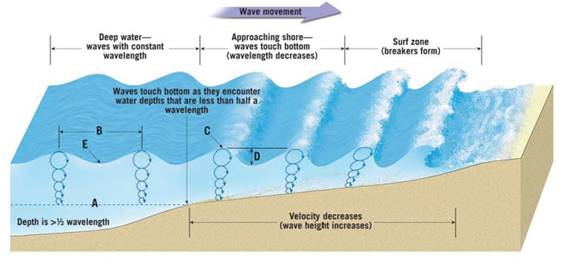
Near the shore in shallow water, do water particles trace out circular or elliptical paths?
Expert Solution & Answer

Learn your wayIncludes step-by-step video

schedule06:38
Students have asked these similar questions
1. Use the elevations in Figure 7.12 as a guide for drawing contour lines. The 100-foot contour line is provided for reference. Using a 20-foot contour interval, draw a contour line for each 20-foot change in elevation below and above 100 feet (e.g., 60 feet, 80 feet, 120 feet). You will have to estimate the elevations between the points. Label each contour line with its elevation.
2. Does the land shown on the topographic map you constructed generally slope downward toward the north or south?
3. Show the direction each stream is flowing by drawing arrows on the map.
Drawing a Topographic Profile
Follow the steps illustrated in Figure 7.13 to draw a topographic profile.
Use the profile graph in Figure 7.14 to construct a west-east profile along the line A-A' on the contour map you completed in Figure 7.12.
Step 1. Our sample profile will be along line A-A. When constructing profiles on maps provided by your instructor, do not draw on the map.
Step 2. Lay a piece of paper along the line of the profile you want to construct. In this example this is line A-A'. Mark each place where a contour line intersects the edge of the paper and note the elevation of the contour line.
Step 3. On a separate piece of paper, draw a horizontal line slightly longer than your profile line, A-A'. Select a vertical scale for your profile that begins slightly. below the lowest elevation along the profile and extends slightly beyond the highest elevation. Mark this scale on either side of the horizontal line. Lay the marked paper edge (from Step 2) along the horizontal…
When contour lines cross streams or dry stream channels, they form a V that points upstream. Draw arrows next to three of the streams (shown in blue) to indicate the direction in which each is flowing.
Chapter 12 Solutions
EBK APPLICATIONS AND INVESTIGATIONS IN
Ch. 12.1 - Prob. 1ACh. 12.1 - Below what depth would a submarine have to...Ch. 12.2 - Prob. 1ACh. 12.2 - Near the shore in shallow water, do water...Ch. 12.2 - In shallow water, are water particles in the wave...Ch. 12.2 - As waves approach the shore, do their heights...Ch. 12.2 - In the surf zone, is the water in the crest of a...Ch. 12.2 - What is the velocity of deep-water waves that have...Ch. 12.2 - At what water depth will a deep-water wave with a...Ch. 12.2 - At what water depth will the wave described in...
Ch. 12.2 - What two factors determine how far from the...Ch. 12.2 - Imagine that you are standing on a beach but...Ch. 12.2 - Along some shorelines, incoming waves cause the...Ch. 12.2 - One type of ocean wave, call a tsunami, is usually...Ch. 12.3 - Prob. 1ACh. 12.3 - At approximately what water depth- 3, 6, 12, or 24...Ch. 12.3 - Draw a dashed line on Figure 12.2 to indicate...Ch. 12.3 - Will wave erosion be most severe on the headland...Ch. 12.3 - What effect will the concentrated energy from wave...Ch. 12.4 - Prob. 1ACh. 12.4 - Name three shoreline features that are produced,...Ch. 12.4 - Use an arrow to indicate the location and...Ch. 12.4 - Use an arrow to indicate the location and...Ch. 12.5A - Prob. 1ACh. 12.5A - Next to each of the features listed below,...Ch. 12.5A - Label a moraine terrace, a wave-cut cliff, and a...Ch. 12.5A - Label a baymouth bar and a spit in Figure 12.8.Ch. 12.5A - Label a sea arch, a tombolo, a spit, a wave-cut...Ch. 12.5B - Prob. 1ACh. 12.5B - Point Reyes, located in the bottom-left corner of...Ch. 12.5B - Several depositional features near Drakes Estero...Ch. 12.5B - Follow Limantour Spit from its western tip at the...Ch. 12.5B - What geologic feature is Estero de Limantour?Ch. 12.5B - Limantour Spit may eventually extend across the...Ch. 12.5B - Locate the bench mark BM with an elevation of 552...Ch. 12.5B - What feature indicates that the headland called...Ch. 12.5B - List at least two features on the map that are...Ch. 12.6 - Prob. 1ACh. 12.6 - Which surface-ocean current travels completely...Ch. 12.6 - Which surface-ocean current flows along the...Ch. 12.6 - What is the name of the surface-ocean current...Ch. 12.6 - Is the general circulation of the surface currents...Ch. 12.6 - In the South Atlantic, is the general circulation...Ch. 12.7 - Prob. 1ACh. 12.7 - What process causes the Mediterranean intermediate...Ch. 12.7 - Figure 12.13 illustrates a simplified model of...Ch. 12.7 - Assume that water sinking in the North Atlantic...Ch. 12.8A - Prob. 1ACh. 12.8A - Write the word spring or neap above the period of...Ch. 12.8A - Which coastal area experiences the largest tidal...Ch. 12.8A - Which coastal area experiences the smallest tidal...Ch. 12.8A - Notice that the phases of the Moon are shown at...Ch. 12.8B - Prob. 1ACh. 12.8B - Classify each of the tidal patterns shown in...Ch. 12.8C - Prob. 1ACh. 12.8C - Prob. 2ACh. 12.8C - Prob. 3ACh. 12.8C - Prob. 4ACh. 12.8C - Prob. 5ACh. 12 - Prob. 1LRCh. 12 - What happens to wavelength and wave height as a...Ch. 12 - Refer 10 Figure 12.16 page 214 Identify the tidal...Ch. 12 - Is the circulation of the surface-ocean currents...Ch. 12 - Describe the difference between a spring tide and...Ch. 12 - Explain what causes spring tides.Ch. 12 - During which lunar phases are neap tides most...Ch. 12 - Which of the tidal patterns illustrated in Figure...Ch. 12 - On Figure 12.20, page 218, identify the features...
Additional Science Textbook Solutions
Find more solutions based on key concepts
Match the following examples of mutagens. Column A Column B ___a. A mutagen that is incorporated into DNA in pl...
Microbiology: An Introduction
HOW DO WE KNOW? In this chapter, we have focused on genetic systems present in bacteria and on the viruses that...
Concepts of Genetics (12th Edition)
One isomer of methamphetamine is the addictive illegal drug known as crank. Another isomer is a medicine for si...
Campbell Essential Biology (7th Edition)
Modified True/False 3. __________ Aquatic microorganisms are more prevalent near the surface than at the bottom...
Microbiology with Diseases by Body System (5th Edition)
What distinguishes the mass spectrum of 2,2-dimethylpropane from the mass spectra of pentane and isopentane?
Organic Chemistry (8th Edition)
What is the difference between cellular respiration and external respiration?
Human Physiology: An Integrated Approach (8th Edition)
Knowledge Booster

Similar questions
- Coal-burning electric power plants in the Pa Midwest have contributed to acid rain in the eastern United States. Other energy sources would most likely be costlier than coal, thereby raising electricity rates. Should citizens in eastern states be able to pressure utility companies in the Midwest to change their method of generating electricity? What mechanisms might be available to make these changes? How effective are these mechanisms?arrow_forwardWhat renewable energy source provides the majority of renewable energy?arrow_forwardWhat are the general characteristics of renewable energy sources?arrow_forward
- Imagine you are an official with the Department of Energy and are in the budgeting process for alternative energy research. Decide where you would invest money and explain why you made your choice. What do you think the political repercussions of your decision would be? Why?arrow_forwardCoal-burning electric power plants in the Midwest have contributed to acid rain in the eastern United States. Other energy sources would most likely be costlier than coal, thereby raising electricity rates. Should citizens in eastern states be able to pressure utility companies in the Midwest to change their method of generating electricity? What mechanisms might be available to make these changes? How effective are these mechanisms?arrow_forwardWhat percent of world energy comes from renewable energy sources?arrow_forward
arrow_back_ios
SEE MORE QUESTIONS
arrow_forward_ios
Recommended textbooks for you
 Applications and Investigations in Earth Science ...Earth ScienceISBN:9780134746241Author:Edward J. Tarbuck, Frederick K. Lutgens, Dennis G. TasaPublisher:PEARSON
 Exercises for Weather & Climate (9th Edition)Earth ScienceISBN:9780134041360Author:Greg CarbonePublisher:PEARSON
 Environmental ScienceEarth ScienceISBN:9781260153125Author:William P Cunningham Prof., Mary Ann Cunningham ProfessorPublisher:McGraw-Hill Education
 Earth Science (15th Edition)Earth ScienceISBN:9780134543536Author:Edward J. Tarbuck, Frederick K. Lutgens, Dennis G. TasaPublisher:PEARSON
 Environmental Science (MindTap Course List)Earth ScienceISBN:9781337569613Author:G. Tyler Miller, Scott SpoolmanPublisher:Cengage Learning
 Physical GeologyEarth ScienceISBN:9781259916823Author:Plummer, Charles C., CARLSON, Diane H., Hammersley, LisaPublisher:Mcgraw-hill Education,
Applications and Investigations in Earth Science ...
Earth Science
ISBN:9780134746241
Author:Edward J. Tarbuck, Frederick K. Lutgens, Dennis G. Tasa
Publisher:PEARSON
Exercises for Weather & Climate (9th Edition)
Earth Science
ISBN:9780134041360
Author:Greg Carbone
Publisher:PEARSON
Environmental Science
Earth Science
ISBN:9781260153125
Author:William P Cunningham Prof., Mary Ann Cunningham Professor
Publisher:McGraw-Hill Education
Earth Science (15th Edition)
Earth Science
ISBN:9780134543536
Author:Edward J. Tarbuck, Frederick K. Lutgens, Dennis G. Tasa
Publisher:PEARSON
Environmental Science (MindTap Course List)
Earth Science
ISBN:9781337569613
Author:G. Tyler Miller, Scott Spoolman
Publisher:Cengage Learning
Physical Geology
Earth Science
ISBN:9781259916823
Author:Plummer, Charles C., CARLSON, Diane H., Hammersley, Lisa
Publisher:Mcgraw-hill Education,