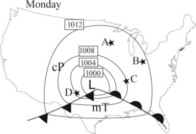
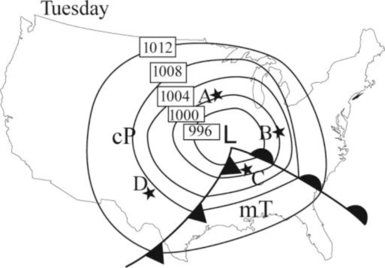
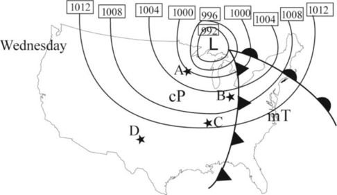
Labelling the air masses in the maps in Figure 10-2.
Answer to Problem 1E
The following picture shows the air mass on Monday.
The following picture shows the air mass on Tuesday.
The following picture shows the air mass on Wednesday.
Explanation of Solution
According to Norwegian polar front theory, the mid latitude cyclones are occurring in northern hemisphere along a stationary front, when two different temperature of air masses flowing in opposite direction in the same front.
A separating barrier is formed between these two air masses and wave like a surface flow is developed, such as warm air conveyer belt.
When cold air overtakes the warm air and it is separated from the center of the low-pressure occluded front is formed and pave the way for steepest pressure gradient.
The surface flow forms an isobar with the low pressure at the center of the wave and at final stage, the flow is inward and counterclockwise. Finally, air mass will start to weaken, and then storm will start to disintegrate.
Always mid latitude cyclones require two different extreme temperature air masses. In summer, the different in temperature is less compared to that of in winter and spring. Hence, mid latitude cyclones are occurring in less over United States in hot season compared to that of in winter and spring.
Always moisture characteristics are represented by small letter and temperature characteristics are represented as capital letter. The following are the examples of different air mass representation.
- maritime equatorial – mE
- maritime tropical –mT
- maritime polar –mP
- continental tropical –cT
- continental polar – cP
- continental arctic–cA
Below the warm front, air mass categorized as mT and it is warm. This air mass contains moisture in general. Above the cold front, the air mass categorized as cP and it is generally cold and dry.
Want to see more full solutions like this?
Chapter 10 Solutions
Exercises for Weather & Climate Plus Mastering Meteorology with eText -- Access Card Package (9th Edition)

- Consider Cronon’s study of wilderness, as discussed by Kanazawa (2023). In what ways, if any, would it have been appropriate for Cronon to have used quantitative methods in his study of the concept of wilderness, and to what end? Why were qualitative methods particularly appropriate for the study, given the nature of his research topic?arrow_forwardWhy might drought actually cause fire risk to reduce in a desert area?arrow_forwardPart 1: A completely saturated sample of sandstone has a bulk density of 2.61 g/cm³, an effective porosity of 10 percent, and a total porosity of 12 percent. Determine the density of the solid phase (i.e., the density of the mineral). Part 2: One cubic meter of quartz sand has a dry mass of 2,320 kg. a) Calculate the porosity of the sand. b) Calculate the mass (in kg) of the sand for the following degrees of saturation: 25 percent, 75 percent, 100 percent. Part 3: A sample of quartz sand has a dry mass of 753.7 kg and a volume of 0.36 m³. a) Calculate the porosity of the sand. b) Calculate the mass (in kg) of the sand assuming a degree of saturation equal to 62 percent.arrow_forward
- What is an oxbow lake and how is it formed?arrow_forwardFor the past 3 million years the earth has experienced glacial-interglacial cycles at regular intervals that coincide with the Milankovitch Cycles. Please briefly describe the three Milankovitch Cycles and their timescales. What is the leading theory for why the timing of glacial-interglacial cycles is connected to these Milankovitch Cycles?arrow_forwardWhy do waterfalls move backwards over time? In your explanation, please use the term “nickpoint”?arrow_forward
- The picture below is of the Kaskawulsh Glacier in Yukon, Canada. What is the name of the type of feature that the red arrows are pointing to in the middle of the glacier and how are these features formed? In your answer please also define the term lateral moraine and how lateral moraines relate to the feature with the red arrows?arrow_forwardit was stated that one major effect of rivers is to flatten out the continents. How do rivers flatten continents?arrow_forwardThe figure below shows the average change in glacier mass per unit area for various mountainous regions around the world. Why are the globe’s mountain glaciers shrinking? Does glacial melt increase or decrease the amount of water stored on the continents? What are the factors in the continental water budget equation that must change in order to restore equilibrium when glaciers melt ? What is the effect on global sea level?arrow_forward
- What is continental precipitation recycling ?Using the concept of precipitation, please explain why changes in landcover in one place can feed back to impact the climate not only in the area where the landcover change occurred but also in other regions?arrow_forwardIn the western United States, does severe forest fire tend to increase or decrease streamflow? What are the two main reasons hypothesized to cause this effect?arrow_forwardForest-fire sizes in the western US have grown rapidly in recent decades. made the case that this was not due to increased human population and resultant human-caused ignitions. What was the main evidence for this?arrow_forward
 Applications and Investigations in Earth Science ...Earth ScienceISBN:9780134746241Author:Edward J. Tarbuck, Frederick K. Lutgens, Dennis G. TasaPublisher:PEARSON
 Exercises for Weather & Climate (9th Edition)Earth ScienceISBN:9780134041360Author:Greg CarbonePublisher:PEARSON
 Environmental ScienceEarth ScienceISBN:9781260153125Author:William P Cunningham Prof., Mary Ann Cunningham ProfessorPublisher:McGraw-Hill Education
 Earth Science (15th Edition)Earth ScienceISBN:9780134543536Author:Edward J. Tarbuck, Frederick K. Lutgens, Dennis G. TasaPublisher:PEARSON
 Environmental Science (MindTap Course List)Earth ScienceISBN:9781337569613Author:G. Tyler Miller, Scott SpoolmanPublisher:Cengage Learning
 Physical GeologyEarth ScienceISBN:9781259916823Author:Plummer, Charles C., CARLSON, Diane H., Hammersley, LisaPublisher:Mcgraw-hill Education,