Using Figure 8-2:
- a. Circle the area with the greatest pressure gradient.
- b. Use arrows to show the direction of pressure gradient force at a few locations. (These are typically drawn perpendicular to isobars.)
- c. Label a region where you would expect the lightest winds.
(a)
The area with the greatest pressure gradient in Figure 8-2 using circle.
Answer to Problem 1E
The map showing the area with the greatest pressure gradient is given below:
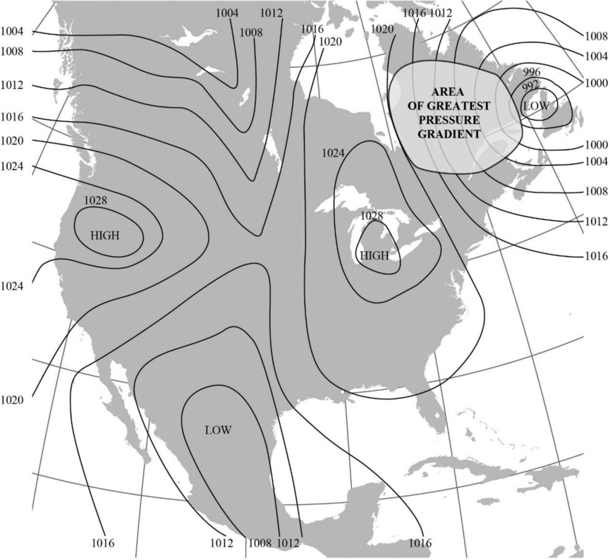
Explanation of Solution
“The magnitude of pressure gradient force is a function of the pressure difference between two points and air density.”
The map given in Figure 8-2 shows isobars, which are lines that connect areas with equal pressure. Closer isobars represent areas with higher pressure gradient. On the basis of this, the greatest pressure gradient is marked using a circle in the map towards the top right side of the Figure.
(b)
The direction of pressure gradient force at some locations in Figure 8-2 using arrows.
Answer to Problem 1E
The map with the direction of pressure gradient force at some locations indicated using arrows is shown below:
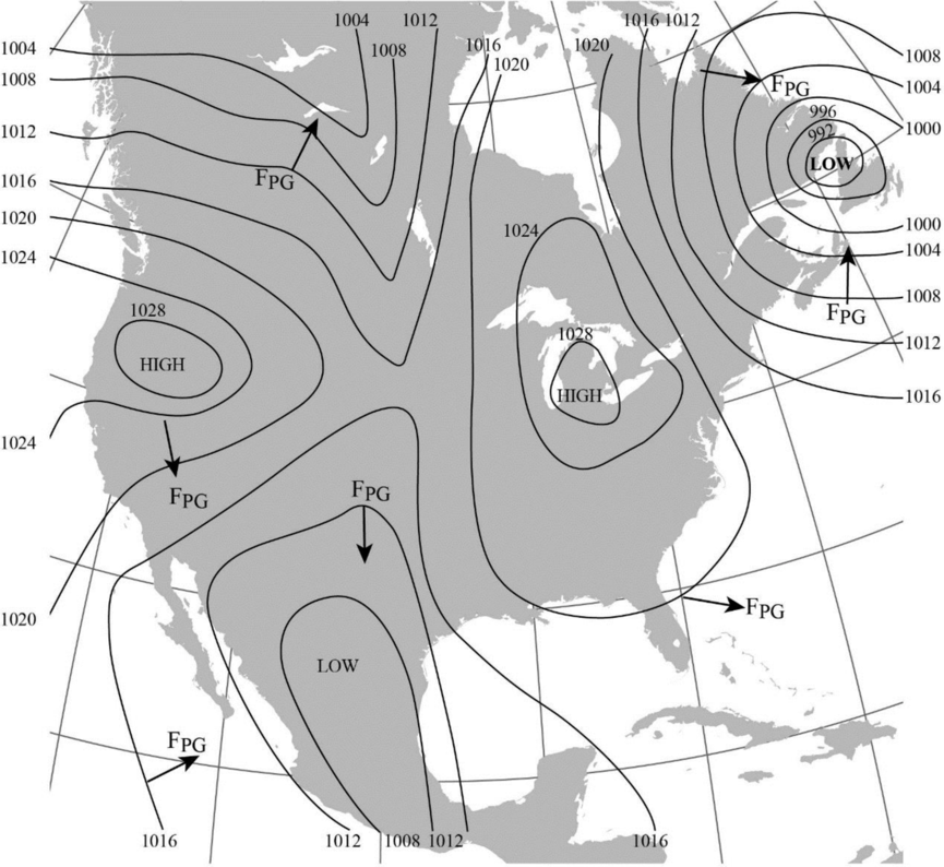
Explanation of Solution
The direction of pressure gradient force is usually drawn perpendicular to the isobars. The pressure gradient force is generally directed from the region of high pressure to lower pressure.
(c)
The region where the lightest winds are expected to occur in Figure 8-2.
Answer to Problem 1E
The area expected to experience the lightest winds is labelled in the map given below:
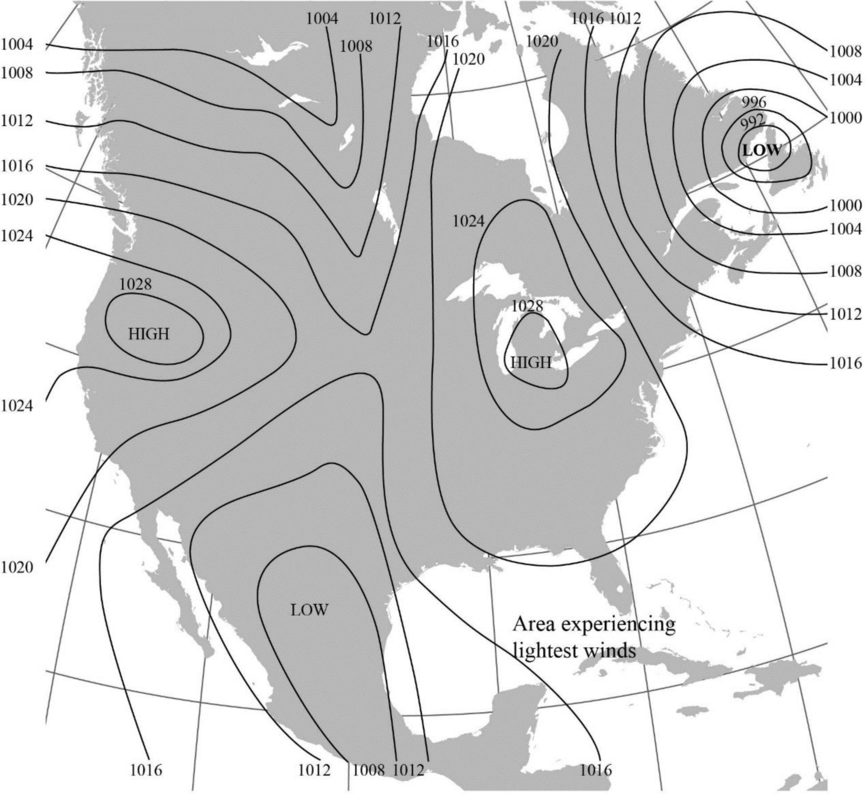
Explanation of Solution
The isobars that are widely-spaced generally denote a gradual pressure gradient and lighter winds whereas the closely-spaced isobars denote steep pressure gradient and stronger winds.
Want to see more full solutions like this?
Chapter 8 Solutions
Exercises for Weather & Climate (9th Edition)
Additional Science Textbook Solutions
Introductory Chemistry (6th Edition)
Campbell Biology in Focus (2nd Edition)
Organic Chemistry (8th Edition)
Campbell Biology (11th Edition)
Microbiology: An Introduction
Chemistry: An Introduction to General, Organic, and Biological Chemistry (13th Edition)

- plastic bottles are better than glass bottles due to their cost-effectiveness, practicality in transportation and use, and advancements in sustainable production. How is this true?arrow_forwardShale and siltstone volcanic ash. erosjon surfaçe limestone sandstone erosion surface pegmatite granite slate dike BUY Aparrow_forwardRetreating glacier Bedrock Till Stratified drift ▲ Figure 9.7 This diagram showing common depositional landforms depicts a hypothetical area affected by ice sheets in the recent geologic past. (Drumlin photo courtesy of Ward's Natural Science Establishment; esker photo by Richard P. Jacobs/ JLM Visuals; kame photo by John Dankwardt; kettle lake photo by Carlyn Iverson/Science Source)arrow_forward
- Figure 9.9 is a stereogram showing a portion of the area covered by the Whitewater, Wisconsin, topographic map (Figure 9.10, page 160). Use the stereogram and the map to complete the following. 7. The streamlined, asymmetrical hills composed of till, labeled B, are what type of feature? 8. Examine the shape of the features labeled B on the map in Figure 9.10. How can these features be used to determine the direction of ice flow in a glaciated area? 9. Using the features labeled B in Figure 9.10 as a guide, draw an arrow on the map to indicate the direction of ice movement that occurred in this region. 10. What is the likely location of the outwash plain on the map? Identify and label the area "outwash plain." (Hint: Refer to Figure 9.7.) 11. Label the area covered by ground moraine. 12. What term is applied to the numerous almost circular depressions designated with the letter C?arrow_forwardFigure 9.9 is a stereogram showing a portion of the area covered by the Whitewater, Wisconsin, topographic map (Figure 9.10, page 160). Use the stereogram and the map to complete the following. (I can only upload two images, so if you have figure 9.9 in Applications and Investigations in Earth Science 9th Edition it would help a lot) 1. After examining the map and stereogram, draw a line on the map to outline the area illustrated on the stereogram. 2. What evidence on the map indicates that portions of the area are poorly drained? On what part of the map are these features located? 3. Use Figure 9.11 to draw a topographic profile of the X-Y line on Figure 9.10. 4. Is the general topography of the land in Sections 7 and 8 in the northwest portion of the region higher or lower in elevation than the land around the letter A located near the center of the map? Is it more or less hilly? 5. Is the area that coincides with Kettle Moraine State Forest higher or lower in elevation than the…arrow_forwardFigure 9.9 is a stereogram showing a portion of the area covered by the Whitewater, Wisconsin, topographic map (Figure 9.10, page 160). Use the stereogram and the map to complete the following. 1. After examining the map and stereogram, draw a line on the map to outline the area illustrated on the stereogram. 2. What evidence on the map indicates that portions of the area are poorly drained? On what part of the map are these features located? 3. Use Figure 9.11 to draw a topographic profile of the X-Y line on Figure 9.10. 4. Is the general topography of the land in Sections 7 and 8 in the northwest portion of the region higher or lower in elevation than the land around the letter A located near the center of the map? Is it more or less hilly? 5. Is the area that coincides with Kettle Moraine State Forest higher or lower in elevation than the land to the northwest and southeast? 6. The feature labeled A on the map is a long ridge composed of till. Is this ridge an esker, an end moraine,…arrow_forward
- Lab 9: Oceans & Coastal Systems GEOG 1113L – Introduction to Landforms Lab Name: I. How the Coast Works 1. What area is considered the shore? (2 points) 2. Describe the type of area that is required for a beach to form. (4 points) 3. Beaches require constructive waves, which are defined as what? (2 points) 4. What is longshore drift? (3 points) 5. What is the difference between attrition and abrasion? (3 points) 6. What artificial barrier do humans use to protect the coast from high tide? (1 point) 7. What barrier is used to protect against longshore drift? (1 point) II. Coastal Systems This activity can be completed with the use of the USGSarrow_forwardLow angle subduction of an ocean - continental convergent boundary can can lead toarrow_forward10 complete the map: chat All Bookmarks M Gmail YouTube 1. Select the given image below. It will open the link to a Google Doc. 2. Select FILE -> MAKE A COPY to make your own copy of the concept map. Please do not request edit access of the original document. for you. Please hold on while I c Image created 1 oxygen atom paste google drawing here. is neutral with Pure Water exists in three states on Earth changén state Major Properties high surface tension resulti is neutral 1 oxygen atom chian-tate 0 HH pH of exists in three esists in tiree here" As part of this tools You'll notice that in the bottom left the document says "paste google drawing Submit Cancel na e Consle drawing of a molecule of a types of atoms and the charges The concept map is now c Ask anything + Search B& Darrow_forward
 Applications and Investigations in Earth Science ...Earth ScienceISBN:9780134746241Author:Edward J. Tarbuck, Frederick K. Lutgens, Dennis G. TasaPublisher:PEARSON
 Exercises for Weather & Climate (9th Edition)Earth ScienceISBN:9780134041360Author:Greg CarbonePublisher:PEARSON
 Environmental ScienceEarth ScienceISBN:9781260153125Author:William P Cunningham Prof., Mary Ann Cunningham ProfessorPublisher:McGraw-Hill Education
 Earth Science (15th Edition)Earth ScienceISBN:9780134543536Author:Edward J. Tarbuck, Frederick K. Lutgens, Dennis G. TasaPublisher:PEARSON
 Environmental Science (MindTap Course List)Earth ScienceISBN:9781337569613Author:G. Tyler Miller, Scott SpoolmanPublisher:Cengage Learning
 Physical GeologyEarth ScienceISBN:9781259916823Author:Plummer, Charles C., CARLSON, Diane H., Hammersley, LisaPublisher:Mcgraw-hill Education,