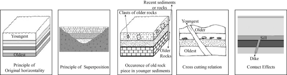
The five principles of relative dating and provide an example for each principle with the help of a sketch.
Answer to Problem 1BYL
Explanation of Solution
The geologic history of an area can be determined by ascertaining the age of geologic units, features, and events. The first step that can be used to determine the age of a rock relative to one another is the method of relative dating. Geoscientists assign the actual numbers in thousands to billions of years using analytical laboratory methods or isotopic dating to this relative chronology. To compare the ages of different rock layers and to correlate one rock unit relative to one another, fossils are also used. The five main principles of relative dating include the original horizontality, principle of superposition, cross-cutting relation, the occurrence of an older rock piece in younger sediment or rock, and contact effects.
The deposition of most sediments and volcanic units had occurred in more or less a horizontal pattern. The principle used to denote this process is known as principle of original horizontality. When the layers are no longer horizontal, it indicates the occurrence of some events after the formation of that layers. The special environments, such as the face of a sand dune or the undersea slopes of a delta are the few exceptions to the principle.
The principle of superposition states that when the deposition of a sediment layer occurs, it overlies the older rocks or sediments. In a sequence of horizontal sedimentary layer sequence, the oldest layer is on the bottom and the youngest layer is at the top.
The third principle of relative dating describes that a younger sediment or rock can contain pieces of an older rock. It indicates that during the formation of a rock or sedimentary deposit, pieces or clasts of older rocks are incorporated into it.
Principle of cross cutting relation states that the rocks are crosscut by fracture. Therefore, the rocks existed there before the formation of fractures. Mainly, there are two types of fractures. They are joints and faults. The slight pulling apart movement of the rock results in the formation of joints and faults are formed along which rocks on opposite side have moved up and down, side to side or as combination.
When magma erupts on to the surface or solidifies at depth, it comes into contact with the pre-existing rock. In both, this setting involves the baking of magma with adjacent rock or chemical alteration of nearby rocks due to the effects of fluids from the magma. Those type of changes that occurred following the eruption or solidification of magma are termed as contact effects.
Want to see more full solutions like this?
Chapter 9 Solutions
Exploring Geology

- plastic bottles are better than glass bottles due to their cost-effectiveness, practicality in transportation and use, and advancements in sustainable production. How is this true?arrow_forwardShale and siltstone volcanic ash. erosjon surfaçe limestone sandstone erosion surface pegmatite granite slate dike BUY Aparrow_forwardRetreating glacier Bedrock Till Stratified drift ▲ Figure 9.7 This diagram showing common depositional landforms depicts a hypothetical area affected by ice sheets in the recent geologic past. (Drumlin photo courtesy of Ward's Natural Science Establishment; esker photo by Richard P. Jacobs/ JLM Visuals; kame photo by John Dankwardt; kettle lake photo by Carlyn Iverson/Science Source)arrow_forward
- Figure 9.9 is a stereogram showing a portion of the area covered by the Whitewater, Wisconsin, topographic map (Figure 9.10, page 160). Use the stereogram and the map to complete the following. 7. The streamlined, asymmetrical hills composed of till, labeled B, are what type of feature? 8. Examine the shape of the features labeled B on the map in Figure 9.10. How can these features be used to determine the direction of ice flow in a glaciated area? 9. Using the features labeled B in Figure 9.10 as a guide, draw an arrow on the map to indicate the direction of ice movement that occurred in this region. 10. What is the likely location of the outwash plain on the map? Identify and label the area "outwash plain." (Hint: Refer to Figure 9.7.) 11. Label the area covered by ground moraine. 12. What term is applied to the numerous almost circular depressions designated with the letter C?arrow_forwardFigure 9.9 is a stereogram showing a portion of the area covered by the Whitewater, Wisconsin, topographic map (Figure 9.10, page 160). Use the stereogram and the map to complete the following. (I can only upload two images, so if you have figure 9.9 in Applications and Investigations in Earth Science 9th Edition it would help a lot) 1. After examining the map and stereogram, draw a line on the map to outline the area illustrated on the stereogram. 2. What evidence on the map indicates that portions of the area are poorly drained? On what part of the map are these features located? 3. Use Figure 9.11 to draw a topographic profile of the X-Y line on Figure 9.10. 4. Is the general topography of the land in Sections 7 and 8 in the northwest portion of the region higher or lower in elevation than the land around the letter A located near the center of the map? Is it more or less hilly? 5. Is the area that coincides with Kettle Moraine State Forest higher or lower in elevation than the…arrow_forwardFigure 9.9 is a stereogram showing a portion of the area covered by the Whitewater, Wisconsin, topographic map (Figure 9.10, page 160). Use the stereogram and the map to complete the following. 1. After examining the map and stereogram, draw a line on the map to outline the area illustrated on the stereogram. 2. What evidence on the map indicates that portions of the area are poorly drained? On what part of the map are these features located? 3. Use Figure 9.11 to draw a topographic profile of the X-Y line on Figure 9.10. 4. Is the general topography of the land in Sections 7 and 8 in the northwest portion of the region higher or lower in elevation than the land around the letter A located near the center of the map? Is it more or less hilly? 5. Is the area that coincides with Kettle Moraine State Forest higher or lower in elevation than the land to the northwest and southeast? 6. The feature labeled A on the map is a long ridge composed of till. Is this ridge an esker, an end moraine,…arrow_forward
- Lab 9: Oceans & Coastal Systems GEOG 1113L – Introduction to Landforms Lab Name: I. How the Coast Works 1. What area is considered the shore? (2 points) 2. Describe the type of area that is required for a beach to form. (4 points) 3. Beaches require constructive waves, which are defined as what? (2 points) 4. What is longshore drift? (3 points) 5. What is the difference between attrition and abrasion? (3 points) 6. What artificial barrier do humans use to protect the coast from high tide? (1 point) 7. What barrier is used to protect against longshore drift? (1 point) II. Coastal Systems This activity can be completed with the use of the USGSarrow_forwardLow angle subduction of an ocean - continental convergent boundary can can lead toarrow_forward10 complete the map: chat All Bookmarks M Gmail YouTube 1. Select the given image below. It will open the link to a Google Doc. 2. Select FILE -> MAKE A COPY to make your own copy of the concept map. Please do not request edit access of the original document. for you. Please hold on while I c Image created 1 oxygen atom paste google drawing here. is neutral with Pure Water exists in three states on Earth changén state Major Properties high surface tension resulti is neutral 1 oxygen atom chian-tate 0 HH pH of exists in three esists in tiree here" As part of this tools You'll notice that in the bottom left the document says "paste google drawing Submit Cancel na e Consle drawing of a molecule of a types of atoms and the charges The concept map is now c Ask anything + Search B& Darrow_forward
- due today at 2pm, the problems have been done already, is there anyway you can draw the diagrams i was supposed to for each problem because I am confused on how to draw themarrow_forwarddue today at 2pm, the problem have been done already, is there anyway you can draw the diagrams i was supposed to for this because I am confused on how to draw themarrow_forwardTHIS IS DUE AT 2PM TODAY, I JUST NEED HELP WITH THE DRAWINGS THATS IT CAN SOMEONE PLEASE HELP MEarrow_forward
 Applications and Investigations in Earth Science ...Earth ScienceISBN:9780134746241Author:Edward J. Tarbuck, Frederick K. Lutgens, Dennis G. TasaPublisher:PEARSON
 Exercises for Weather & Climate (9th Edition)Earth ScienceISBN:9780134041360Author:Greg CarbonePublisher:PEARSON
 Environmental ScienceEarth ScienceISBN:9781260153125Author:William P Cunningham Prof., Mary Ann Cunningham ProfessorPublisher:McGraw-Hill Education
 Earth Science (15th Edition)Earth ScienceISBN:9780134543536Author:Edward J. Tarbuck, Frederick K. Lutgens, Dennis G. TasaPublisher:PEARSON
 Environmental Science (MindTap Course List)Earth ScienceISBN:9781337569613Author:G. Tyler Miller, Scott SpoolmanPublisher:Cengage Learning
 Physical GeologyEarth ScienceISBN:9781259916823Author:Plummer, Charles C., CARLSON, Diane H., Hammersley, LisaPublisher:Mcgraw-hill Education,