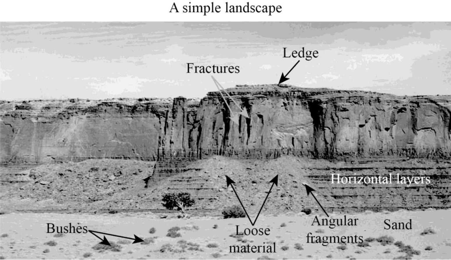
A simple sketch of a landscape, labeling some of the main components.
Answer to Problem 1BYL
Explanation of Solution
The sketch of a simple landscape is given above, which may be acted upon by geological agents such as wind and water. Various features can be observed evidently on the landscape. Firstly, looking at the cliff, it can be seen that the layers are nearly horizontal.
On further observation, small and large fractures can be seen on the confronting surface of the cliff. The ledges and other rugged parts of the cliff would be made up of resistant rocks. As these rocks are able to withstand weathering due to most geological agents, they remain intact, even after the removal of the soft materials.
The loose materials observed towards the foot of the cliff may include weathered materials and the eroded materials from the top of the cliff. These loose materials contain angular fragments and fine rounded fragments. There is also soil that has mostly sand-sized grains. The grains might have been brought by wind also. The area is not a vegetated one; only bushes are seen in the region.
Want to see more full solutions like this?
Chapter 9 Solutions
Exploring Earth Science

- Answer the last question only. "Make a prediction where the next island in the Hawaiian island will form mark the location on the map"arrow_forwardDiscussion Question: Glacial (or Ice) and Periglacial Landscapes A+ The Ice and Glaciers chapter focuses on the Cryosphere, the ice on our planet. I always find it interesting to consider the Earth's Hydrologic Cycle, our water in all of the different phases: solid ice, liquid water, and water vapor (a gas). In place number one for the majority of the World's water, we have the oceans. In place number two, we have ice. Neither one is available to us for drinking water at this point. Amazingly enough, in place number three is groundwater before lakes and streams. Water has led to many problems in the history of California, the United States, and even the world. Nevada Idaho B) at Flats el Mone Lake Arizona Severe Dry Lake (c) Mono Lake, tufa towersarrow_forwardTitle: Urban water management integration with sustainable strategies brings resilience by implementing green infrastructure alongside wastewater recycling and climate-adaptive solutions. Outline of topic: Increased urbanization together with climate changes forces cities to find solutions for their simultaneous water shortage and flooding problems. The preservation of water resources needs sustainable urban water management strategies that combine ecological health maintenance with these priorities. This study investigates combined strategies that involve rainwater collection together with wastewater treatment and the deployment of green infrastructure consisting of urban wetlands alongside permeable pavements. The research aims to discover multi-purpose solutions that decrease flood dangers together with water shortages while maintaining ecological health for long-term urban water management success. The research investigates ways in which novel solutions assist cities to create…arrow_forward
- Evaporation Evaporation 320,000 km³ Oceans Hydrologic Cycle Precipitation Precipitation 96,000 km³ Precipitation 284,000 km³ Evaporation/Transpiration 60,000 km³ Runoff 36,000 km³ Runoff Infiltrationarrow_forward1. Globally, from which source does more water evaporate into the atmosphere: oceans or land? 2. Approximately what percentage of the total water evaporated into the atmosphere comes from the oceans?Percentage from oceans = Ocean evaporation/Total evaporation × 100% = _____ % 3. Notice in Figure 8.1 that more water evaporates from the oceans than is returned directly by precipitation. If sea level is not dropping, identify a source of water for the oceans in addition to precipitation. 4. Worldwide, about how much of the precipitation that falls on the land becomes runoff: 35, 55, or 75 percent? 5. Much of the water that falls on land does not immediately return to the ocean via runoff. Instead, it is temporarily stored in reservoirs such as lakes. In some mountainous and polar regions, what features serve as reservoirs to temporarily store water?arrow_forwardEnergy conservation is one way to decrease dependence on fossil fuels. What are some things that can be done at home, work, or school that would reduce fossil-fuel use and save money?arrow_forward
- Since the 1970s, the median age of people in North America has done what? Increased Decreased Stayed about the same Decreased dramaticallyarrow_forwardNorth America has experienced a demographic transition that resulted in what kind of changes in the population of North America? Lower birthrates, lower death rates, and longer life expectancies Higher birthrates, lower death rates, and longer life expectancies Lower birthrates, higher death rates, and shorter life expectancies Higher birthrates, higher death rates, and shorter life expectanciesarrow_forwardAccording to the views of animal rights activists opposed to animal experimentation which of the following statements applies? Animal experimentation should be permitted only when medical progress cannot be achieved in any other way. Animal experimentation should be permitted only when the animals involved come from a shelter where they were destined to be killed. Animals have the same rights and moral status that human beings do. We should not apply Kant's Practical Imperative to animals.arrow_forward
- 72 ic 18 The planets 1 Can you find eleven Solar System words in the grid? e E W b V e n a e P r r + h C i - PU 0 0 n c e t S c e r P W n P i t e r U 6 r f U n - K σ г m a r S n W e t Y g n d r e E C Y O P U S t a r > S a t U r n 2 Rearrange the letters into the names of the planets. a ucerr My c un Ves e hrtEa g sarM b ruepitj d rntSau f uneNtep_ h nasu Urarrow_forwardAnswer the photoarrow_forwardwhat are your thoughts on the critical importance of soil management and its impact on agricultural productivity and environmental health, and role of conservation tillage. write in first personarrow_forward
 Applications and Investigations in Earth Science ...Earth ScienceISBN:9780134746241Author:Edward J. Tarbuck, Frederick K. Lutgens, Dennis G. TasaPublisher:PEARSON
 Exercises for Weather & Climate (9th Edition)Earth ScienceISBN:9780134041360Author:Greg CarbonePublisher:PEARSON
 Environmental ScienceEarth ScienceISBN:9781260153125Author:William P Cunningham Prof., Mary Ann Cunningham ProfessorPublisher:McGraw-Hill Education
 Earth Science (15th Edition)Earth ScienceISBN:9780134543536Author:Edward J. Tarbuck, Frederick K. Lutgens, Dennis G. TasaPublisher:PEARSON
 Environmental Science (MindTap Course List)Earth ScienceISBN:9781337569613Author:G. Tyler Miller, Scott SpoolmanPublisher:Cengage Learning
 Physical GeologyEarth ScienceISBN:9781259916823Author:Plummer, Charles C., CARLSON, Diane H., Hammersley, LisaPublisher:Mcgraw-hill Education,