
Applications and Investigations in Earth Science (9th Edition)
9th Edition
ISBN: 9780134746241
Author: Edward J. Tarbuck, Frederick K. Lutgens, Dennis G. Tasa
Publisher: PEARSON
expand_more
expand_more
format_list_bulleted
Textbook Question
Chapter 9, Problem 8LR
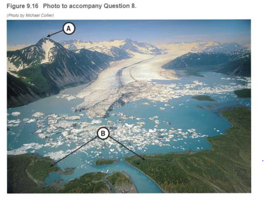
Use Figure 9.16 an image of Alaska's Bear Glacier, to complete the following.
| a. | Identify the erosional feature labeled A. |
| b. | Feature B is a ridge composed of till. Is it more likely an esker or an end moraine? |
| c. | When this photo was taken, is it more likely that Bear Glacier was advancing or retreating? Provide evidence for you answer |
Expert Solution & Answer

Learn your wayIncludes step-by-step video

schedule09:22
Students have asked these similar questions
IM 4G III.
>
Homework 1
۲:۱۱
٢ من ٣
Contouring (EXERCISES)
Contour the following data and complete the two profiles
.0
3
16
25
2117 12
2 .°
15
O
25
35
5
11
.41
20
18
31
43
16
15
4342
19
21
29
40
.30
13
12
.0
5
29
12
19
2
22
+4
15
2
110
9
D
.º
B'
Turtle Island
0
1. What is the contour interval of this map?Contour interval: ____ feet
2. What is the difference in elevation from one index contour to the next?Difference in elevation:____feet
3. On most quadrangles, each section is numbered in red and outlined in red or, occasionally, dashed black lines. Find Section 9, located near the center of the map, and measure its width and length in milesusing the bar scale provided.Sections are _____ miles(s) wide and ____mile(s) long
4. Locate the small intermittent stream (blue dashed line) just below the red number 9 that denotes Section 9. Toward what general direction does the stream flow? Explain how you arrived at your answer.Direction of stream flow: ____Explain: ______
5. What is the approximate elevation of the point marked with an X in Section 8?Elevation of X _____ feet
6. What is the approximate relief between point X and the surface of Turquoise Lake?Relief:____feet
7. Which of the following phrases best describes the topography of Tennessee…
1. The difference in elevation between adjacent contour lines is called the contour interval. Look at the bottom of this map to identify the contour interval.Contour interval: ________
2. What is the difference in elevation between Points A and B?Difference in elevation: _____ feet
3. Notice that every fifth contour line, called an index contour, is printed as a bold brown line, and the elevation of that line is provided (in feet). List the elevations for each index contour shown on this map._____________ feet, ___________ feet,___________feet
4. Closely spaced contours indicate steep slopes. Which of the four slopes shown with red arrows labeled 1-4 is the steepest? Which is the least steep?Steepest: _______Least steep: _____
5. One or more roughly circular closed contours indicate a hill. Which of the landforms labeled B-E are hills?Hill landforms: ______
6. Closed contours with hachures (short lines) that point downslope indicate depressions (basins without outlets). Which of the…
Chapter 9 Solutions
Applications and Investigations in Earth Science (9th Edition)
Ch. 9.1 - Indicate whether you think the following...Ch. 9.1 - Name the four deserts found in the United States.Ch. 9.2 - On the Antelope Peak topographic map, draw a line...Ch. 9.2 - Prob. 2ACh. 9.2 - Prob. 3ACh. 9.2 - Prob. 4ACh. 9.2 - Prob. 5ACh. 9.2 - Prob. 6ACh. 9.2 - Prob. 8ACh. 9.2 - Prob. 9A
Ch. 9.3 - What percentage of Earths land surface do glaciers...Ch. 9.3 - Identify two locations where ice sheets are...Ch. 9.3 - Briefly compare an ice sheet to a valley glacier.Ch. 9.4 - As a glacier retreats, it sometimes stalls and...Ch. 9.4 - On Figure 9.7, label an area covered by ground...Ch. 9.4 - On Figure 9.7, fill in the appropriate blanks with...Ch. 9.4 - Which area is composed of stratified drift: the...Ch. 9.5 - After examining the map and stereogram, draw a...Ch. 9.5 - What evidence on the map indicates that portions...Ch. 9.5 - Is the general topography of the land in Sections...Ch. 9.5 - Is the area that coincides with Kettle Moraine...Ch. 9.5 - The feature labeled A on the map is a long ridge...Ch. 9.5 - The streamlined, asymmetrical hills composed of...Ch. 9.5 - Prob. 8ACh. 9.5 - Using the features labeled B in Figure 9.10 as a...Ch. 9.5 - What is the likely location of the outwash plain...Ch. 9.5 - Label the area covered by ground moraine.Ch. 9.5 - What term is applied to the numerous almost...Ch. 9.6A - How does a glacier change the shape and depth of a...Ch. 9.6A - How is an arte different from a horn?Ch. 9.6A - Briefly describe the changes that occur in...Ch. 9.6B - Identify the glacial feature indicated by each of...Ch. 9.6B - A tarn is a lake that forms in a cirque. Of the...Ch. 9.6B - The feature marked G on the map is a depositional...Ch. 9.6B - Explain how Turquoise Lake likely formed....Ch. 9.6B - Use Figure 9.14 to draw a topographic profile...Ch. 9.6B - Describe the shape of Lake Fork Valley, based on...Ch. 9.6B - Prob. 7ACh. 9 - Name the area of the United States that is...Ch. 9 - Identify the feature shown by the arrows in Figure...Ch. 9 - List some prominent features found in mountainous...Ch. 9 - Toward what general direction does the landscape...Ch. 9 - If you were working in the field, explain how you...Ch. 9 - Prob. 6LRCh. 9 - What reason did you give for the formation of...Ch. 9 - Use Figure 9.16 an image of Alaskas Bear Glacier,...Ch. 9 - What type of glacier is shown In Figure 9.17?Ch. 9 - Use Figure 9.18 to complete the following. a....
Additional Science Textbook Solutions
Find more solutions based on key concepts
Where is transitional epithelium found and what is its importance at those sites?
Anatomy & Physiology (6th Edition)
EVOLUTION CONNECTION Crossing over is thought to be evolutionarily advantageous because it continually shuffles...
Campbell Biology (11th Edition)
16. Explain some of the reasons why the human species has been able to expand in number and distribution to a g...
Campbell Biology: Concepts & Connections (9th Edition)
Explain all answers clearly, with complete sentences and proper essay structure if needed. An asterisk (*) desi...
Cosmic Perspective Fundamentals
5. In a type of parakeet known as a “budgie,” feather color is controlled by two genes. A yellow pigment is syn...
Genetic Analysis: An Integrated Approach (3rd Edition)
1.1 Write a one-sentence definition for each of the following:
a. chemistry
b. chemical
Chemistry: An Introduction to General, Organic, and Biological Chemistry (13th Edition)
Knowledge Booster

Similar questions
- 1. Use the PLS system to label the townships along the western edge and ranges along the bottom of Part A. 2. Use the PLS system to label each of the sections in the congressional township shown in Part B. 3. In the space provided below, use the PLS system to describe Plots Y and Z. Plot X has been completed as an example.arrow_forwardSOUTH Judith River Eagle Warm Mowry Shak Kooter Thermope Jurassic Ellis Seyenite Porphry Metamorphic Rocks Gravity-Slide Faults Bearpaw Shale 3 Mississippian Mission Canyph Devonian Jefferson Limestone an Platheadbandstor Bakken/3 Forks Shale NORTH Ordovician Bighorn Dolomite Little Rocky Mountains No Scale - Drawing is approximate length of Reservation Hogeland Basin Creating a cross-section requires some subjective decisions on your part, but it needs to be geologically reasonable. For example, the thickness and dip of a planar layer should remain relatively constant unless the map data requires otherwise. Planar layers should also be laterally continuous unless there is evidence otherwise. Similarly, keep the structure as simple as you can. Steps to producing a cross section: I. Choose the location and direction of the profile on the geological map (usually a straight line) II. Draw or plot the topography of the profile on the cross-section III. Add the geological features from the…arrow_forwardsecond question plssarrow_forward
- H D Figure 13.14 4 v C ax. G Figure 13.15 JV T R K 5 ७ हाकालयकाळात Oldest Younges! Oldest 10arrow_forwardPretty much all the solidified lava you see near Kilauea and Mauna Loa is basalt. Using just the satellite imagery, how would you know that these lavas are basaltic (as opposed to andesitic or rhyolitic)?arrow_forwardCompare a passive solar heating system with an active solar heating system.arrow_forward
- Describe what the wind power as an energy source is. Describe 5 advantages of wind power as an energy source. Describe 5 disadvantages of wind power as an energy source. Discuss the future potential wind power as an energy source in the United States. Describe how you would convince the residents of the State of Connecticut to utilize more wind power as an energy sourcearrow_forwardHow is the biofuel ethanol produced?arrow_forwardDistinguish between reserves and resoircesarrow_forward
- Describe what kind of energy source oil ia. Describe 5 advantages of oil as an energy source. Describe 5 disadvantages of oil as energy source. Discuss the future potential of oil as energy source in the United States. Describe how you would convince the residents of the State of Connecticut to utilize more oil as an energy source.arrow_forwardWhat are negative environmental impacts of developing hydroelectric power?arrow_forwardList three negative environmental impacts of using biomass to provide energy.arrow_forward
arrow_back_ios
SEE MORE QUESTIONS
arrow_forward_ios
Recommended textbooks for you
 Applications and Investigations in Earth Science ...Earth ScienceISBN:9780134746241Author:Edward J. Tarbuck, Frederick K. Lutgens, Dennis G. TasaPublisher:PEARSON
 Exercises for Weather & Climate (9th Edition)Earth ScienceISBN:9780134041360Author:Greg CarbonePublisher:PEARSON
 Environmental ScienceEarth ScienceISBN:9781260153125Author:William P Cunningham Prof., Mary Ann Cunningham ProfessorPublisher:McGraw-Hill Education
 Earth Science (15th Edition)Earth ScienceISBN:9780134543536Author:Edward J. Tarbuck, Frederick K. Lutgens, Dennis G. TasaPublisher:PEARSON
 Environmental Science (MindTap Course List)Earth ScienceISBN:9781337569613Author:G. Tyler Miller, Scott SpoolmanPublisher:Cengage Learning
 Physical GeologyEarth ScienceISBN:9781259916823Author:Plummer, Charles C., CARLSON, Diane H., Hammersley, LisaPublisher:Mcgraw-hill Education,
Applications and Investigations in Earth Science ...
Earth Science
ISBN:9780134746241
Author:Edward J. Tarbuck, Frederick K. Lutgens, Dennis G. Tasa
Publisher:PEARSON
Exercises for Weather & Climate (9th Edition)
Earth Science
ISBN:9780134041360
Author:Greg Carbone
Publisher:PEARSON
Environmental Science
Earth Science
ISBN:9781260153125
Author:William P Cunningham Prof., Mary Ann Cunningham Professor
Publisher:McGraw-Hill Education
Earth Science (15th Edition)
Earth Science
ISBN:9780134543536
Author:Edward J. Tarbuck, Frederick K. Lutgens, Dennis G. Tasa
Publisher:PEARSON
Environmental Science (MindTap Course List)
Earth Science
ISBN:9781337569613
Author:G. Tyler Miller, Scott Spoolman
Publisher:Cengage Learning
Physical Geology
Earth Science
ISBN:9781259916823
Author:Plummer, Charles C., CARLSON, Diane H., Hammersley, Lisa
Publisher:Mcgraw-hill Education,