
Sketch, label, and discuss the hydrologic cycle.
Earth's water is constantly moving between Earth's surface and atmosphere. The hydrologic cycle describes the continuous movement of water from the oceans to the atmosphere, from the atmosphere to the land, and from the land back to the sea Over most of Earth, the Quantity of precipitation that falls on the land must eventually be accounted for by the sum total of evaporation, transpiration (the release water vapor by vegetation), runoff, and infiltration
A portion of the precipitation that falls on land will soak into the ground through a process called infiltration. If the rate of rainfall exceeds the ability of the surface to absorb it, the additional water flows over the surface and becomes runoff. Runoff initially flows in broad sheets that form tiny channels called rills The rills merge to form gullies, which eventually join to create streams erosion by both groundwater and running water wears down the land and shapes Earth's surface
Figure 8.1 illustrates Earth's water balance, a quantitative view of the hydrologic cycle The figure Implies a globally uniform exchange of water between Earth's atmosphere and surface, but factors such as climate, steepness of slope, surface materials, vegetation, and degree of urbanization produce local variations
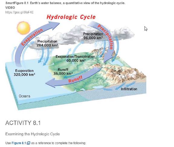
Globally from which source does more water evaporate into the atmosphere oceans or land?

Learn your wayIncludes step-by-step video

Chapter 8 Solutions
Applications and Investigations in Earth Science (9th Edition)
Additional Science Textbook Solutions
Campbell Biology: Concepts & Connections (9th Edition)
Living By Chemistry: First Edition Textbook
Cosmic Perspective Fundamentals
Anatomy & Physiology (6th Edition)
Campbell Biology (11th Edition)
Chemistry: An Introduction to General, Organic, and Biological Chemistry (13th Edition)

- 1. List the five REASONS for seasons. Please be careful. I am not looking for INFLUENCES on seasons such as, Global Warming and winds. Think about axial parallelism, for example. (20 points). 2. Are we closest to the sun during the Northern Hemisphere summer or winter (5 points)? Is it called the aphelion or the perihelion (5 points)? 3. When does everyone receive 12 hours of day and 12 hours of night (5 points)? 4. During what Northern Hemisphere season do the penguins in Antarctica (the Southern Hemisphere) receive 24 hours of darkness (5 points)? 5. The water molecule is polar with two offset hydrogen atoms bonded to one oxygen atom. What are two characteristics or properties of the water molecule due to its polarity (10 points)? 6. The dew point temperature is 68 degrees Fahrenheit. Relative humidity is at 50%. Saturation vapor pressure is 24 millibars. What is the actual vapor pressure in the air in units of millibars? It is not a trick question. Look in the textbook under…arrow_forwardDiscussion Question: Ecosystems Essentials A+ of 1000 Exof-spil OCEAN The Human Denominator Assignment As we learn about how the earth works, we learn to identify the different earth spheres and how they overlap and affect one another. An understanding of the Earth's systems and spheres takes practice. More importantly, we can see the "Domino Effect" of the spheres as they interact with one another. We have learned that while endogenic processes are separate from exogenic process, the lithosphere affects the atmosphere which affects the hydrosphere, and the biosphere. Now, we can reverse the situation and consider how the biosphere, you and I, affectarrow_forwardGo to the following link. https://climate.nasa.gov/evidence/ Read over all of the links about the Climate Evidence, Causes, and Effects. Then, write a 15-20 sentences about what you learned.arrow_forward
- Make the answer be 2.0 without changing the question. Explain each step and why the answer is 2.0arrow_forward8. The halocline (halo = salt, cline = slope) is a layer of ocean water where there is a rapid change in salin-ity with depth. Label the halocline on Figure 11.9.arrow_forward1. After examining the map and stereogram, draw a line on the map to outline the area illustrated on the stereogram. 2. What evidence on the map indicates that portions of the area are poorly drained? On what part of the map are these features located? 3. Use Figure 9.11 to draw a topographic profile of the X-Y line on Figure 9.10. 4. Is the general topography of the land in Sections 7 and 8 in the northwest portion of the region higher or lower in elevation than the land around the letter A located near the center of the map? Is it more or less hilly? 5. Is the area that coincides with Kettle Moraine State Forest higher or lower in elevation than the land to the northwest and southeast? 6. The feature labeled A on the map is a long ridge composed of till. Is this ridge an esker, an end moraine, or a drumlin?arrow_forward
 Applications and Investigations in Earth Science ...Earth ScienceISBN:9780134746241Author:Edward J. Tarbuck, Frederick K. Lutgens, Dennis G. TasaPublisher:PEARSON
 Exercises for Weather & Climate (9th Edition)Earth ScienceISBN:9780134041360Author:Greg CarbonePublisher:PEARSON
 Environmental ScienceEarth ScienceISBN:9781260153125Author:William P Cunningham Prof., Mary Ann Cunningham ProfessorPublisher:McGraw-Hill Education
 Earth Science (15th Edition)Earth ScienceISBN:9780134543536Author:Edward J. Tarbuck, Frederick K. Lutgens, Dennis G. TasaPublisher:PEARSON
 Environmental Science (MindTap Course List)Earth ScienceISBN:9781337569613Author:G. Tyler Miller, Scott SpoolmanPublisher:Cengage Learning
 Physical GeologyEarth ScienceISBN:9781259916823Author:Plummer, Charles C., CARLSON, Diane H., Hammersley, LisaPublisher:Mcgraw-hill Education,