Applications and Investigations in Earth Science (8th Edition)
8th Edition
ISBN: 9780321934529
Author: Edward J. Tarbuck, Frederick K. Lutgens, Dennis G. Tasa, Kenneth G. Pinzke
Publisher: PEARSON
expand_more
expand_more
format_list_bulleted
Textbook Question
Chapter 4.8, Problem 1A
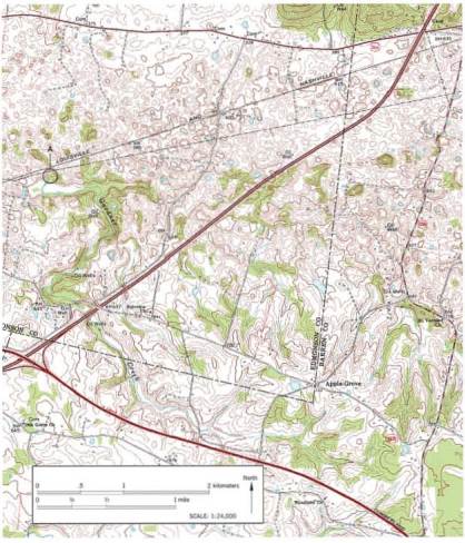
Locate three sinkholes (depressions) on the map and mark each with an X. (Hint: Look for closed contour lines with hachures.)
Expert Solution & Answer

Learn your wayIncludes step-by-step video

schedule09:12
Students have asked these similar questions
I need help with part c and d
I need help with tracing over part A can someone help me out
I need help with question 3 can someone help me.
Chapter 4 Solutions
Applications and Investigations in Earth Science (8th Edition)
Ch. 4.1 - Sketch, label, and discuss the hydrologic cycle....Ch. 4.1 - Sketch, label, and discuss the hydrologic cycle....Ch. 4.1 - Prob. 3ACh. 4.1 - Sketch, label, and discuss the hydrologic cycle....Ch. 4.1 - Sketch, label, and discuss the hydrologic cycle....Ch. 4.1 - Prob. 6ACh. 4.2 - Of the three materials you tested coarse sand,...Ch. 4.2 - Prob. 2ACh. 4.2 - Prob. 3ACh. 4.2 - Prob. 4A
Ch. 4.3 - Does urbanization increase or decrease the peak...Ch. 4.3 - What is the effect of urbanization on lag time the...Ch. 4.3 - Does total runoff occur over a longer or shorter...Ch. 4.3 - Prob. 4ACh. 4.4A - Prob. 1ACh. 4.4A - Is the terrain in section 14, located on the west...Ch. 4.4A - Label the areas that topographically resemble...Ch. 4.4A - Describe the topography in the lower half of...Ch. 4.4A - Section 17 contains a portion of the valley...Ch. 4.4A - Which of the following best describes the shape of...Ch. 4.4A - Calculate the gradient, or slope, of this portion...Ch. 4.4A - Approximately how many feet is the Missouri River...Ch. 4.4A - What are the features in the river labeled with...Ch. 4.4A - Based on your answer to Question 9, are the...Ch. 4.4A - Over time, as tributaries erode and lengthen their...Ch. 4.4B - Draw an arrow on the map to indicate the direction...Ch. 4.4B - Prob. 2ACh. 4.4B - Approximately how many feet is the Genesee River...Ch. 4.4B - The path of the Genesee River can best be...Ch. 4.4B - Which phrase most accurately describes most of the...Ch. 4.4B - Prob. 7ACh. 4.4C - Approximately what percentage of the map area is...Ch. 4.4C - Prob. 2ACh. 4.4C - Prob. 3ACh. 4.4C - Prob. 4ACh. 4.4C - Prob. 5ACh. 4.4C - Write a statement that compares the width of the...Ch. 4.4C - Prob. 7ACh. 4.4C - On which of the three maps is the gradient of the...Ch. 4.4C - Prob. 9ACh. 4.5 - Label the zone of saturation, the unsaturated...Ch. 4.5 - Describe the shape of the water table in...Ch. 4.5 - Prob. 3ACh. 4.5 - Use a pencil to shade the area between the dashed...Ch. 4.5 - Prob. 5ACh. 4.6 - Calculate the elevation of the water table at each...Ch. 4.6 - Assume that a dye was put into well A on May 10,...Ch. 4.7 - What is the general relationship between ground...Ch. 4.7 - What was the total ground subsidence, and what was...Ch. 4.7 - During the period shown on the graph, on average,...Ch. 4.7 - Was the ground subsidence that occurred between...Ch. 4.7 - Notice that minimal subsidence occurred from 1935...Ch. 4.8 - Locate three sinkholes depressions on the map and...Ch. 4.8 - Notice that several sinkholes have water in them....Ch. 4.8 - Describe what is happening to Gardner Creek in the...Ch. 4 - Write a statement or two describing the movement...Ch. 4 - Assume that you need to determine the rate at...Ch. 4 - Write a brief paragraph summarizing the results of...Ch. 4 - Prob. 4LRCh. 4 - Prob. 5LRCh. 4 - Name and describe two features you would expect to...Ch. 4 - Prob. 7LRCh. 4 - Assume that you have decided to drill a water...Ch. 4 - Prob. 9LR
Additional Science Textbook Solutions
Find more solutions based on key concepts
Why are the top predators in food chains most severely affected by pesticides such as DDT?
Campbell Essential Biology (7th Edition)
Which one of the following is not a fuel produced by microorganisms? a. algal oil b. ethanol c. hydrogen d. met...
Microbiology: An Introduction
Could an organism be a fermenter and also be both MR and V—P negative? Explain.
Laboratory Experiments in Microbiology (12th Edition) (What's New in Microbiology)
Match each of the following items with all the terms it applies to:
Human Physiology: An Integrated Approach (8th Edition)
Explain why genetic Variation within a population is a prerequisite for evolution.
Campbell Biology (11th Edition)
1.6 Read the labels on products used to wash your dishes. What are the names of some chemicals contained in tho...
Chemistry: An Introduction to General, Organic, and Biological Chemistry (13th Edition)
Knowledge Booster

Similar questions
- I need help with tracing part A could I get some helparrow_forwardActivity 12.3: Wave Refraction Pgs 202-203Figure 12.2 is a map view of a headland along a coastline. The water depths are shown by blue contour lines. As you complete the following questions, assume that waves with a wavelength of 60 feet are approaching the shoreline from the bottom left of the figure. 1. At approximately what water depth-10, 20, 30, or 40 feet-will the approaching waves begin to touch bottom and slow down? (Hint: Recall that this occurs when the water depth is one-half the wavelength.) Approximately the 30-foot depth line. 2. Using the wave shown in Figure 12.2 as a starting point, sketch a series of lines to illustrate the wave refraction that will occur as the wave approaches the shore by following these steps:Step 1: Mark the position on the 30-foot contour line where the wave front will first touch bottom.Step 2: Knowing that the section of the wave that touches bottom will slow down first, sketch the shape of the wave front when it reaches the 20-foot contour…arrow_forwardN Depth of water contour Advancing wave crest Beach HEADLAND -10'- 20'- -30- Land -40- -50'- 0 Beach Scale 200 feetarrow_forward
- I need help with part a and barrow_forwardIn fig A13.2.3, what are the gradient and sinuosity of Passage Creek from G and G? Refer to figs. 12.3 and 12.4 for help measuring gradient and sinuosity. Show your calculations. You will graph it later in the activity. Gradient: ______ ft/mi Sinuosity:arrow_forwardplease do these for me and explain in detailarrow_forward
- Activity 12.3: Wave Refraction Pgs 202-203Figure 12.2 is a map view of a headland along a coastline. The water depths are shown by blue contour lines. As you complete the following questions, assume that waves with a wavelength of 60 feet are approaching the shoreline from the bottom left of the figure. 1. At approximately what water depth-10, 20, 30, or 40 feet-will the approaching waves begin to touch bottom and slow down? (Hint: Recall that this occurs when the water depth is one-half the wavelength.) 2. Using the wave shown in Figure 12.2 as a starting point, sketch a series of lines to illustrate the wave refraction that will occur as the wave approaches the shore by following these steps:Step 1: Mark the position on the 30-foot contour line where the wave front will first touch bottom.Step 2: Knowing that the section of the wave that touches bottom will slow down first, sketch the shape of the wave front when it reaches the 20-foot contour line.Step 3: Using the same…arrow_forwardN Depth of water contour Advancing wave crest Beach HEADLAND -10- -20- -30' Land -40'- 50- 0 Beach Scale 200 feetarrow_forwardActivity 12.5A: Identifying Shoreline Features Pgs 206-2081. Use the descriptions of shoreline features provided above to label the structures in Figures 12.5 and 12.6. The same feature may appear more than once. 2. Next to each of the features listed below, indicate whether it is the result of erosional or depositional processes.Sea stack:Wave-cut cliff:Spit:Barrier island:Baymouth bar:Marine terrace:arrow_forward
arrow_back_ios
SEE MORE QUESTIONS
arrow_forward_ios
Recommended textbooks for you
 Applications and Investigations in Earth Science ...Earth ScienceISBN:9780134746241Author:Edward J. Tarbuck, Frederick K. Lutgens, Dennis G. TasaPublisher:PEARSON
 Exercises for Weather & Climate (9th Edition)Earth ScienceISBN:9780134041360Author:Greg CarbonePublisher:PEARSON
 Environmental ScienceEarth ScienceISBN:9781260153125Author:William P Cunningham Prof., Mary Ann Cunningham ProfessorPublisher:McGraw-Hill Education
 Earth Science (15th Edition)Earth ScienceISBN:9780134543536Author:Edward J. Tarbuck, Frederick K. Lutgens, Dennis G. TasaPublisher:PEARSON
 Environmental Science (MindTap Course List)Earth ScienceISBN:9781337569613Author:G. Tyler Miller, Scott SpoolmanPublisher:Cengage Learning
 Physical GeologyEarth ScienceISBN:9781259916823Author:Plummer, Charles C., CARLSON, Diane H., Hammersley, LisaPublisher:Mcgraw-hill Education,
Applications and Investigations in Earth Science ...
Earth Science
ISBN:9780134746241
Author:Edward J. Tarbuck, Frederick K. Lutgens, Dennis G. Tasa
Publisher:PEARSON
Exercises for Weather & Climate (9th Edition)
Earth Science
ISBN:9780134041360
Author:Greg Carbone
Publisher:PEARSON
Environmental Science
Earth Science
ISBN:9781260153125
Author:William P Cunningham Prof., Mary Ann Cunningham Professor
Publisher:McGraw-Hill Education
Earth Science (15th Edition)
Earth Science
ISBN:9780134543536
Author:Edward J. Tarbuck, Frederick K. Lutgens, Dennis G. Tasa
Publisher:PEARSON
Environmental Science (MindTap Course List)
Earth Science
ISBN:9781337569613
Author:G. Tyler Miller, Scott Spoolman
Publisher:Cengage Learning
Physical Geology
Earth Science
ISBN:9781259916823
Author:Plummer, Charles C., CARLSON, Diane H., Hammersley, Lisa
Publisher:Mcgraw-hill Education,