The reason for more often use of term food web instead of the food chain for species in a community.
Answer to Problem 1RQ
In the food chain, each level consists of single species whereas in food web several species occupy a single level. That is the reason that food web is commonly used in place of the food chain.
Explanation of Solution
Pictorial representation: Fig.1 represents a food web. Fig.2 represents food chain.
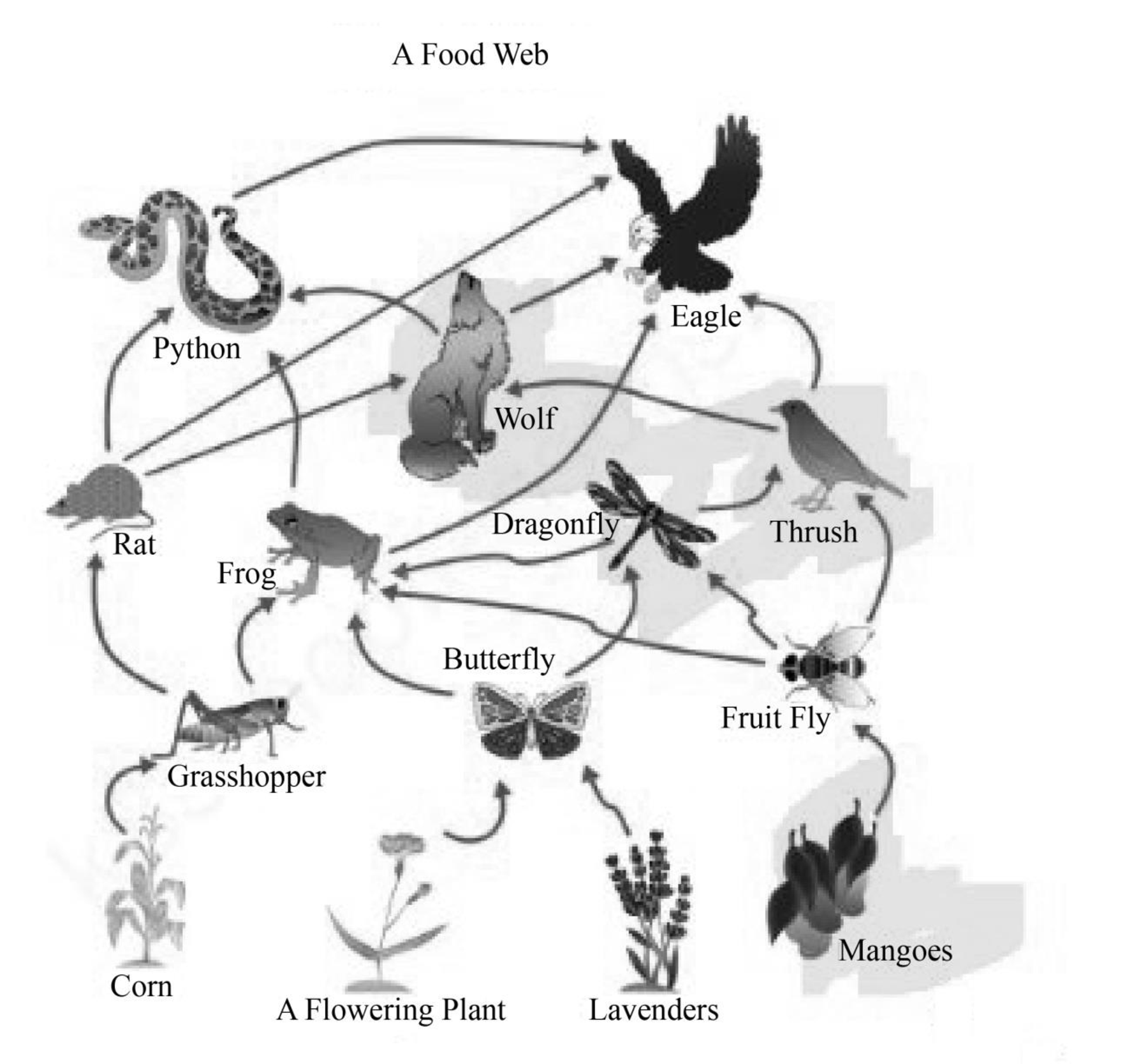
Fig.1: Food web
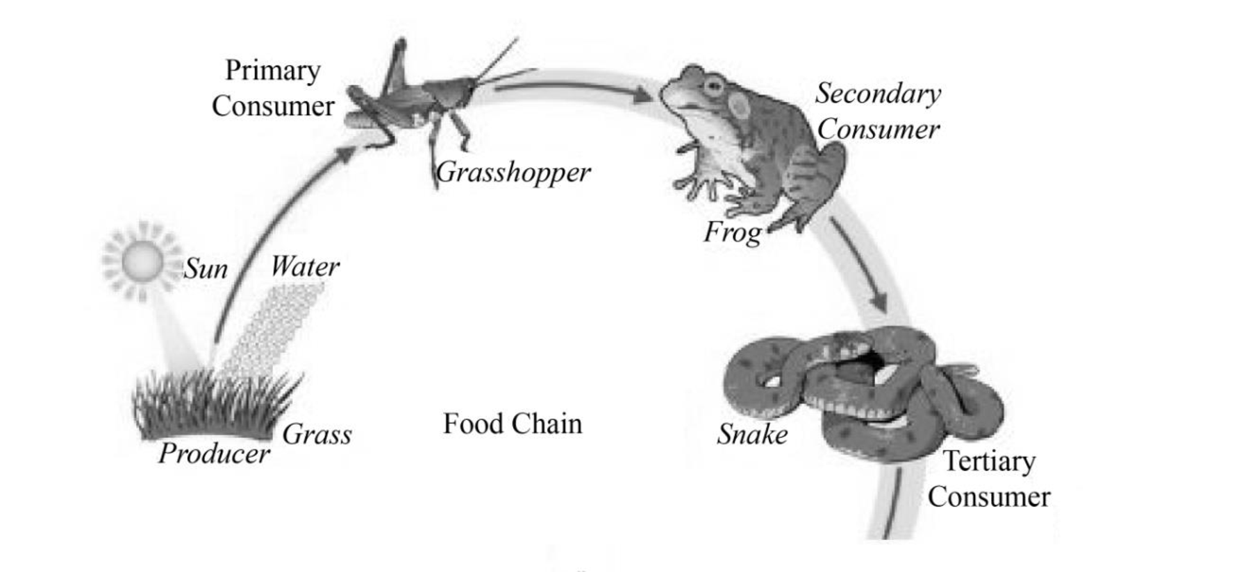
Fig.2: Food chain.
In an ecosystem, plants are primary producer which perform photosynthesis. Herbivorous animals feed on plants and they are called primary consumers. Carnivorous feed on herbivorous animals and called secondary consumers. Top carnivores feed on secondary consumers so they are called tertiary consumers.
(i) Food chain: Food chain is sequence based upon the feeding habits of organism living in a community. The basic sequence is from producers to tertiary consumers. For example, plants are producers, a grasshopper used to feed on plants, the grasshopper is consumed by a frog and frog is further consumed by a snake. In this way, the food chain continues.
(ii) Food web: In a food web, each level is occupied by several species. The consumer not only feeds on only one kind of prey, they usually feed on several kinds of prey. For example, a grasshopper, a butterfly and fruit fly feed on plants. These insects can be consumed by a frog. The frog can be consumed by a snake or an eagle.
Food web is more appropriate instead of the food chain because in food chain each species occupy only one level, but in reality, each level is occupied by several species.
Want to see more full solutions like this?

- 1. Use the PLS system to label the townships along the western edge and ranges along the bottom of Part A. 2. Use the PLS system to label each of the sections in the congressional township shown in Part B. 3. In the space provided below, use the PLS system to describe Plots Y and Z. Plot X has been completed as an example.arrow_forwardSOUTH Judith River Eagle Warm Mowry Shak Kooter Thermope Jurassic Ellis Seyenite Porphry Metamorphic Rocks Gravity-Slide Faults Bearpaw Shale 3 Mississippian Mission Canyph Devonian Jefferson Limestone an Platheadbandstor Bakken/3 Forks Shale NORTH Ordovician Bighorn Dolomite Little Rocky Mountains No Scale - Drawing is approximate length of Reservation Hogeland Basin Creating a cross-section requires some subjective decisions on your part, but it needs to be geologically reasonable. For example, the thickness and dip of a planar layer should remain relatively constant unless the map data requires otherwise. Planar layers should also be laterally continuous unless there is evidence otherwise. Similarly, keep the structure as simple as you can. Steps to producing a cross section: I. Choose the location and direction of the profile on the geological map (usually a straight line) II. Draw or plot the topography of the profile on the cross-section III. Add the geological features from the…arrow_forwardsecond question plssarrow_forward
- H D Figure 13.14 4 v C ax. G Figure 13.15 JV T R K 5 ७ हाकालयकाळात Oldest Younges! Oldest 10arrow_forwardPretty much all the solidified lava you see near Kilauea and Mauna Loa is basalt. Using just the satellite imagery, how would you know that these lavas are basaltic (as opposed to andesitic or rhyolitic)?arrow_forwardCompare a passive solar heating system with an active solar heating system.arrow_forward
- Describe what the wind power as an energy source is. Describe 5 advantages of wind power as an energy source. Describe 5 disadvantages of wind power as an energy source. Discuss the future potential wind power as an energy source in the United States. Describe how you would convince the residents of the State of Connecticut to utilize more wind power as an energy sourcearrow_forwardHow is the biofuel ethanol produced?arrow_forwardDistinguish between reserves and resoircesarrow_forward
- Describe what kind of energy source oil ia. Describe 5 advantages of oil as an energy source. Describe 5 disadvantages of oil as energy source. Discuss the future potential of oil as energy source in the United States. Describe how you would convince the residents of the State of Connecticut to utilize more oil as an energy source.arrow_forwardWhat are negative environmental impacts of developing hydroelectric power?arrow_forwardList three negative environmental impacts of using biomass to provide energy.arrow_forward
 Applications and Investigations in Earth Science ...Earth ScienceISBN:9780134746241Author:Edward J. Tarbuck, Frederick K. Lutgens, Dennis G. TasaPublisher:PEARSON
 Exercises for Weather & Climate (9th Edition)Earth ScienceISBN:9780134041360Author:Greg CarbonePublisher:PEARSON
 Environmental ScienceEarth ScienceISBN:9781260153125Author:William P Cunningham Prof., Mary Ann Cunningham ProfessorPublisher:McGraw-Hill Education
 Earth Science (15th Edition)Earth ScienceISBN:9780134543536Author:Edward J. Tarbuck, Frederick K. Lutgens, Dennis G. TasaPublisher:PEARSON
 Environmental Science (MindTap Course List)Earth ScienceISBN:9781337569613Author:G. Tyler Miller, Scott SpoolmanPublisher:Cengage Learning
 Physical GeologyEarth ScienceISBN:9781259916823Author:Plummer, Charles C., CARLSON, Diane H., Hammersley, LisaPublisher:Mcgraw-hill Education,