The map of an idealized tectonic plate and the earthquake hazards associated with each type of plate edge.
Answer to Problem 1QR
The map of an idealized tectonic plate contains three types of plate edges. The divergent motion causes small earthquakes, slide-past motion causes major earthquakes, and the convergent motion causes very large magnitudes of earthquake.
Explanation of Solution
Pictorial representation: Fig.1 represents a map of an idealized tectonic plate.
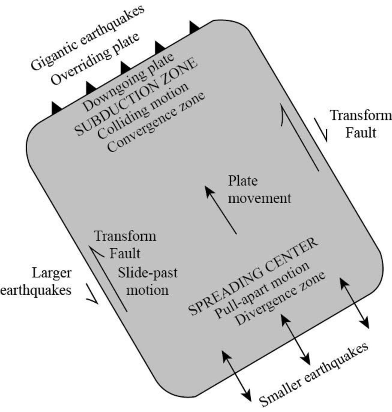
Fig.1: Map of an idealized tectonic plate
An earthquake is defined as a natural event which is caused by the sudden shaking of the surface of the earth. The occurrence of an earthquake is explained by the plate-tectonics theory, in which the lithosphere breaks into rigid plates that move away from, past, and into other rigid plates. This process is seen on the ground as individual faults, where the Earth ruptures and the two sides move past each other in earthquake-generating events.
The earthquake hazards that are associated with each type of plate edge are as follows:
(i) Divergent or pull-apart motion:
The divergent motion of tectonic plates occurs at the spreading centers. It causes the rocks to fail in tension, which results in the easy rupture of the rocks. It results in the yield of many small earthquakes.
(ii) Slide-past motion:
This motion occurs at the curved paths of Earth in the transform faults and causes the plates to slide and shear with each other. It results in causing major earthquakes.
(iii) Convergent or push together motion:
It occurs at the subduction zones and in continent-continent collisions, which causes the rocks to fail in compression. This motion stores immense amount of energy, which is released during very large magnitudes of earthquake.
Want to see more full solutions like this?
Chapter 4 Solutions
EBK NATURAL DISASTERS

- N Depth of water contour Advancing wave crest Beach HEADLAND -10'- 20'- -30- Land -40- -50'- 0 Beach Scale 200 feetarrow_forwardI need help on Part C question 2arrow_forwardcan you please show me the drawings for each of these i want to make sure I have them right, as well as explaing the answers, thank youarrow_forward
- I need help on Part Carrow_forwardI need help with part a and barrow_forwardIn fig A13.2.3, what are the gradient and sinuosity of Passage Creek from G and G? Refer to figs. 12.3 and 12.4 for help measuring gradient and sinuosity. Show your calculations. You will graph it later in the activity. Gradient: ______ ft/mi Sinuosity:arrow_forward
- please do these for me and explain in detailarrow_forwardActivity 12.3: Wave Refraction Pgs 202-203Figure 12.2 is a map view of a headland along a coastline. The water depths are shown by blue contour lines. As you complete the following questions, assume that waves with a wavelength of 60 feet are approaching the shoreline from the bottom left of the figure. 1. At approximately what water depth-10, 20, 30, or 40 feet-will the approaching waves begin to touch bottom and slow down? (Hint: Recall that this occurs when the water depth is one-half the wavelength.) 2. Using the wave shown in Figure 12.2 as a starting point, sketch a series of lines to illustrate the wave refraction that will occur as the wave approaches the shore by following these steps:Step 1: Mark the position on the 30-foot contour line where the wave front will first touch bottom.Step 2: Knowing that the section of the wave that touches bottom will slow down first, sketch the shape of the wave front when it reaches the 20-foot contour line.Step 3: Using the same…arrow_forwardN Depth of water contour Advancing wave crest Beach HEADLAND -10- -20- -30' Land -40'- 50- 0 Beach Scale 200 feetarrow_forward
- Activity 12.5A: Identifying Shoreline Features Pgs 206-2081. Use the descriptions of shoreline features provided above to label the structures in Figures 12.5 and 12.6. The same feature may appear more than once. 2. Next to each of the features listed below, indicate whether it is the result of erosional or depositional processes.Sea stack:Wave-cut cliff:Spit:Barrier island:Baymouth bar:Marine terrace:arrow_forward3. Label a marine terrace, a wave-cut cliff, and a wave-cut platform in Figure 12.7. 4. Label a baymouth bar and a spit in Figure 12.8.arrow_forwardMy question: How does unequal school resources and fundings affect job opportunities for underprivileged groups? Can you go into 2. Gather facts related to your topic by using recommended Dallas College Library databases, like PubMed and Psychology Gale Academic OneFile. select important facts and statistics that will help you to answer your research question. Articles you select must be published within 5 years (2019-2024). Can you find as much articles that you can that answer my question.arrow_forward
 Applications and Investigations in Earth Science ...Earth ScienceISBN:9780134746241Author:Edward J. Tarbuck, Frederick K. Lutgens, Dennis G. TasaPublisher:PEARSON
 Exercises for Weather & Climate (9th Edition)Earth ScienceISBN:9780134041360Author:Greg CarbonePublisher:PEARSON
 Environmental ScienceEarth ScienceISBN:9781260153125Author:William P Cunningham Prof., Mary Ann Cunningham ProfessorPublisher:McGraw-Hill Education
 Earth Science (15th Edition)Earth ScienceISBN:9780134543536Author:Edward J. Tarbuck, Frederick K. Lutgens, Dennis G. TasaPublisher:PEARSON
 Environmental Science (MindTap Course List)Earth ScienceISBN:9781337569613Author:G. Tyler Miller, Scott SpoolmanPublisher:Cengage Learning
 Physical GeologyEarth ScienceISBN:9781259916823Author:Plummer, Charles C., CARLSON, Diane H., Hammersley, LisaPublisher:Mcgraw-hill Education,