Exercises for Weather & Climate (9th Edition)
9th Edition
ISBN: 9780134041360
Author: Greg Carbone
Publisher: PEARSON
expand_more
expand_more
format_list_bulleted
Textbook Question
Chapter 3, Problem 14E
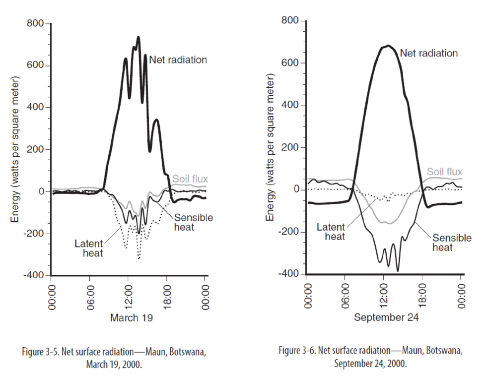
Why is the peak net radiation approximately the same on the two dates?
Expert Solution & Answer

Learn your wayIncludes step-by-step video

schedule02:33
Students have asked these similar questions
Exercise Ten / Geologic Time
177
d. Based on the ages of the rock layers in outcrop 1, identify an unconformity. Remember that an unconformity is
a break in the rock record. Draw a wavy line on the figure to represent the unconformity.
Ginkgo
Period
Ginkgo
Lepidodendron
Dimetrodon
Period
Tyrannosaurus
Calamites
Inoceramus
Period
Lepidodendron
Rhodocrinites
Archimedes
Eurypterus
Period
Sharks
Period
Phacops
Agnostus
Outcrop 1
Period
Period
Ichthyosaurus
Period
Sharks
Ceratites
Period
Paleolimulus
A Figure 10.17 Sequences of sedimentary rock layers to accompany Question 7.
10.8 Numerical Dating with Radioactivity
■ Explain the principle of radiometric dating, including half-life, parent isotope,
and daughter product.
Radioactivity has provided a reliable means for calculating the numerical (absolute) age of
rocks, a procedure called radiometric dating. Radioactive isotopes, such as uranium-238,
emit particles from their nuclei that we call radiation. Ultimately, the process of decay…
Dike K
H
Fault L
Figure 10.12 Geologic block diagram of a hypothetical area.
C
Youngest
B
Intrusion J
Oldest
"
Chrome
File Edit View History
0
O
↑
X
O
SIS
Ω
4-511
6
Bookmarks Profiles
Tab Window
Help
X
4-510
X
4-509
+
cl.castlelearning.com/Review/CLO/Student/Assignment/Questions?assignmentID=13205009&tid=9976762
0
Qad c
4-511
Select Language
98
Mon May 5 5:26 PM
Relaunch to update
CED Sal
Salvatore Burgio
5009
Which cross section best represents the pattern of sediments deposited on the bottom of a lake as the velocity of the stream entering the lake steadily decreased?
-Top
2.
esc
Bottom
Top
Bottom
Top
Bottom
Top
Bottom
Submit Answer
Zoom: Standard
Note
Bookmark
Eliminator Highlighter Line Reader Reference
Calculator
Ruter
Protractor
MAY
LO
XA
tv N
Aa
MacBook Pro
C
D
Search or type URL
ABGAB
1
2
#
$
%
&
3
4
5
6
7
8
00
Q
W
E
R
T
Y
U
tab
A
S
D
F
G
caps lock
shift
H
H
(
9
0
O
+ 11
Listen
P
[
]
J
K
L
?
Z
X
C
V
B
N
M
H
command
option
L
H
fn
control
option
command
delete
return
shift
Chapter 3 Solutions
Exercises for Weather & Climate (9th Edition)
Ch. 3 - a. The Sun has an average surface temperature of...Ch. 3 - a. In question 1, how many times warmer is the Sun...Ch. 3 - Calculate the wavelength of maximum emission for...Ch. 3 - In what portion of the electromagnetic spectrum...Ch. 3 - Why is incoming short-wave radiation higher in...Ch. 3 - The solar noon solar radiation values at the top...Ch. 3 - Based on the incoming shortwave radiation curves,...Ch. 3 - At 12:30 p.m. on August 2, the surface receives...Ch. 3 - Thinking about the radiation laws, why does...Ch. 3 - Prob. 10E
Ch. 3 - Table 3-2 shows the four radiation fluxes at 7:00...Ch. 3 - Using the surface net radiation data, explain why...Ch. 3 - Explain changes in afternoon air temperature with...Ch. 3 - Why is the peak net radiation approximately the...Ch. 3 - How does the net surface radiation pattern differ...Ch. 3 - In Figure 3-7, draw the stacked bar graph showing...Ch. 3 - How do the proportions of sensible, latent, and...Ch. 3 - The proportion of each of these fluxes depends, in...Ch. 3 - a. Figure 3-9 shows the diurnal air temperature...Ch. 3 - Peak radiation occurs at Maun from mid-November to...Ch. 3 - Water vapor is a very effective greenhouse gas,...Ch. 3 - Prob. 22ECh. 3 - Prob. 25ECh. 3 - Prob. 28ECh. 3 - Prob. 29ECh. 3 - Prob. 30ECh. 3 - Prob. 31ECh. 3 - Prob. 32ECh. 3 - Prob. 33ECh. 3 - Prob. 1RQCh. 3 - Prob. 2RQ
Additional Science Textbook Solutions
Find more solutions based on key concepts
2. Whether an allele is dominant or recessive depends on
a. how common the allele is, relative to other alleles...
Campbell Biology: Concepts & Connections (9th Edition)
How do you think a cell performing cellular respiration rids itself of the resulting CO2?
Campbell Biology in Focus (2nd Edition)
Fibrous connective tissue consists of ground substance and fibers that provide strength, support, and flexibili...
Human Biology: Concepts and Current Issues (8th Edition)
Plants use the process of photosynthesis to convert the energy in sunlight to chemical energy in the form of su...
Campbell Essential Biology with Physiology (5th Edition)
Chlorine has two isotopes, 35Cl and 37Cl; 75.77% of chlorine is 35Cl, and 24.23% is 37Cl. The atomic mass of 35...
Organic Chemistry (8th Edition)
MAKE CONNECTIONS In Concept 20.2, you learned about genome-wide association studies. Explain how these studies...
Campbell Biology (11th Edition)
Knowledge Booster

Similar questions
- I need help with part b and c. I don't want an explanation I need the actual graph, because it's hard to understand an explanation without showing what they mean.arrow_forwardI need help with part b and c. I don't want an explanation I need the actual graph preferably broken down, because it's hard to understand an explanation without showing what they mean.arrow_forwardI need help with part b and c I don't know how to draw it.arrow_forward
- 4. What is the geologic range of the fossil shown in Figure 10.15? From the Ordovician period through the Permian period. 5. What is the geologic range of the fossil shown in Figure 10.16? From the Cambrian period through the Permian period. 6. Imagine that you have discovered a rock outcrop that contains the fossils identified in Questions 4 and 5. What is the geologic range of this rock?From theperiod through the period.arrow_forward4. What is the geologic range of the fossil shown in Figure 10.15? From the period through the period5. What is the geologic range of the fossil shown in Figure 10.16? From the period through the period.arrow_forwardACTIVITY 10.6 Types of Fossils Pg 174 1. Refer to Figure 10.13. Which photo(s) (A-1) best illustrate(s) the methods of fossilization or fossil evidence listed below? (Photos/letters may be used more than once.)Permineralization: The small internal cavities and pores of an original organism that are filled with precipitated mineral matter. Photo(s):Cast: The space once occupied by a dissolved shell or other structure that is subsequently filled with mineral matter. Photo(s):Carbonization: Preservation that occurs when fine sediment encases delicate plant or animal forms and leaves a residue of carbon, Photo(s):Impression: A replica of an organism, such as a leaf, left in fine-grained sedimentary rock. Photo(s):Amber: Hardened resin of ancient trees that preserved delicate organisms such as insects. Photo(s):Indirect evidence: Traces of prehistoric life but not the organism itself. Photo(s):arrow_forward
- ACTIVITY 10.7 Fossils as Time Indicators Pgs 175-176Use Figure 10.14, page 175, to complete the following. 1. What is the geologic range of plants that belong to the group Ginkgo?From theperiod through theperiod. 2. What is the geologic range of Lepidodendron, an extinct coal-producing plant?From theperiod through theperiod. 3. Imagine that you have discovered an outcrop of sedimentary rock that contains fossil shark teeth and fossils of Archimedes. In which time periods might this rock have formed?From theperiod through theperiod.arrow_forwardACTIVITY 10.4 Unconformities Pg 1721. Label the angular unconformity and disconformity on Figure 10.10. 2. Identify the types of unconformities in Figure 10.11A and Figure 10.11Barrow_forwardACTIVITY 10.3 Principles of Cross-Cutting and Inclusions Pg 171Figure 10.8 is a geologic cross-section of a hypothetical area. Use it to answer the following questions. 1. Is the igneous intrusion, dike E, older or younger than rock layers A-D? 2. Is fault H older or younger than rock layers A-D? 3. Is fault H older or younger than sedimentary layers F and G? 4. Did fault H occur before or after dike E? Explain how you arrived at your answer. 5. What evidence supports the conclusion that the igneous intrusion labeled sili B is more recent than the rock layers on either side (A and C)? ACTIVITY 10.5 Applying Relative Dating Principles Pg 173Use Figure 10.12 to complete the following. 1. Identify and label the unconformities in Figure 10.12. 2. Is rock layer I older or younger than layer H? What relative dating principle did you apply to determine your answer?Rock layer I isthan layer H.Relative dating principle: 3. Is fault L older or younger than rock layer D? What principle did you…arrow_forward
arrow_back_ios
SEE MORE QUESTIONS
arrow_forward_ios
Recommended textbooks for you
 Applications and Investigations in Earth Science ...Earth ScienceISBN:9780134746241Author:Edward J. Tarbuck, Frederick K. Lutgens, Dennis G. TasaPublisher:PEARSON
 Exercises for Weather & Climate (9th Edition)Earth ScienceISBN:9780134041360Author:Greg CarbonePublisher:PEARSON
 Environmental ScienceEarth ScienceISBN:9781260153125Author:William P Cunningham Prof., Mary Ann Cunningham ProfessorPublisher:McGraw-Hill Education
 Earth Science (15th Edition)Earth ScienceISBN:9780134543536Author:Edward J. Tarbuck, Frederick K. Lutgens, Dennis G. TasaPublisher:PEARSON
 Environmental Science (MindTap Course List)Earth ScienceISBN:9781337569613Author:G. Tyler Miller, Scott SpoolmanPublisher:Cengage Learning
 Physical GeologyEarth ScienceISBN:9781259916823Author:Plummer, Charles C., CARLSON, Diane H., Hammersley, LisaPublisher:Mcgraw-hill Education,
Applications and Investigations in Earth Science ...
Earth Science
ISBN:9780134746241
Author:Edward J. Tarbuck, Frederick K. Lutgens, Dennis G. Tasa
Publisher:PEARSON
Exercises for Weather & Climate (9th Edition)
Earth Science
ISBN:9780134041360
Author:Greg Carbone
Publisher:PEARSON
Environmental Science
Earth Science
ISBN:9781260153125
Author:William P Cunningham Prof., Mary Ann Cunningham Professor
Publisher:McGraw-Hill Education
Earth Science (15th Edition)
Earth Science
ISBN:9780134543536
Author:Edward J. Tarbuck, Frederick K. Lutgens, Dennis G. Tasa
Publisher:PEARSON
Environmental Science (MindTap Course List)
Earth Science
ISBN:9781337569613
Author:G. Tyler Miller, Scott Spoolman
Publisher:Cengage Learning
Physical Geology
Earth Science
ISBN:9781259916823
Author:Plummer, Charles C., CARLSON, Diane H., Hammersley, Lisa
Publisher:Mcgraw-hill Education,