To draw:
The Earth’s grid system, including equator and prime meridian and also description of the system used to locate points on Earth’s surface.
Introduction:
The maps and globes display the system of east-west, and north-south lines, which is described as the Earth’s grid.
Explanation of Solution
Pictorial representation: Figure 1 represents the Earth’s grid system.
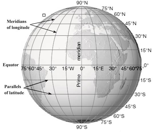
Fig. 1: Earth’s grid system
The north-south lines in figure 1 represent parallels of latitude, and the east-west lines represent meridians of longitude. The Earth’s grid system generates the basis for locating the points on the surface of Earth. The position of a specific point can be determined by the intersection of two lines. At prime meridian, the longitude is described as 0°. The location of a point is measured in degrees west and east of prime meridian from 0° to 180°.
Want to see more full solutions like this?
Chapter 22 Solutions
Applications and Investigations in Earth Science (8th Edition)

- 3. Label a marine terrace, a wave-cut cliff, and a wave-cut platform in Figure 12.7. 4. Label a baymouth bar and a spit in Figure 12.8.arrow_forwardMy question: How does unequal school resources and fundings affect job opportunities for underprivileged groups? Can you go into 2. Gather facts related to your topic by using recommended Dallas College Library databases, like PubMed and Psychology Gale Academic OneFile. select important facts and statistics that will help you to answer your research question. Articles you select must be published within 5 years (2019-2024). Can you find as much articles that you can that answer my question.arrow_forwardhwarrow_forward
- Please answer all parts of the question and show all workarrow_forward1. The field of hydrogeology includes: a. soil water movement b. rainfall runoff and flood generation c. placement of water wells to optimize the quantity and quality of water supplies d. all of the above e. a and c 2. Groundwater occurrence and movement has no direct influence on: a. earthquake activity b. land subsidence c. land slide potential d. hydraulic conductivity e. soil formation f. none of the above 3. In terms of Earth's water budget, groundwater ranks a. higher b. lower 4. Ultimately, the hydrological cycle is driven by: a. geothermal energy fluxes toward Earth's surface b. orographic rainfall due to abrupt changes in elevation c. solar energy fluxes toward Earth's surface d. adiabatic cooling in the atmosphere 5. In the equation below, the variable "Var" refers to: a. void ratio b. pressure head c. hydraulic conductivity d. intrinsic permeability than glaciers and ice caps: P Var = p.garrow_forwardDeep water- waves with constant wavelength Wave movement Approaching shore- waves touch bottom (wavelength decreases) Surf zone (breakers form) Waves touch bottom as they encounter water depths that are less than half a wavelength C E B 00000 00000 Depth is >½ wavelength 0000 0000 Velocity decreases (wave height increases)arrow_forward
 Applications and Investigations in Earth Science ...Earth ScienceISBN:9780134746241Author:Edward J. Tarbuck, Frederick K. Lutgens, Dennis G. TasaPublisher:PEARSON
 Exercises for Weather & Climate (9th Edition)Earth ScienceISBN:9780134041360Author:Greg CarbonePublisher:PEARSON
 Environmental ScienceEarth ScienceISBN:9781260153125Author:William P Cunningham Prof., Mary Ann Cunningham ProfessorPublisher:McGraw-Hill Education
 Earth Science (15th Edition)Earth ScienceISBN:9780134543536Author:Edward J. Tarbuck, Frederick K. Lutgens, Dennis G. TasaPublisher:PEARSON
 Environmental Science (MindTap Course List)Earth ScienceISBN:9781337569613Author:G. Tyler Miller, Scott SpoolmanPublisher:Cengage Learning
 Physical GeologyEarth ScienceISBN:9781259916823Author:Plummer, Charles C., CARLSON, Diane H., Hammersley, LisaPublisher:Mcgraw-hill Education,