Concept explainers
Videos
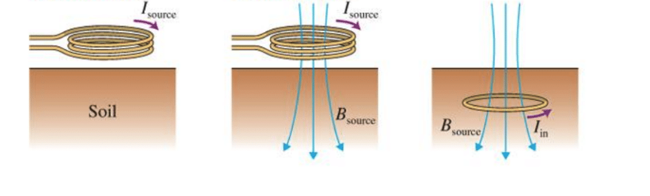
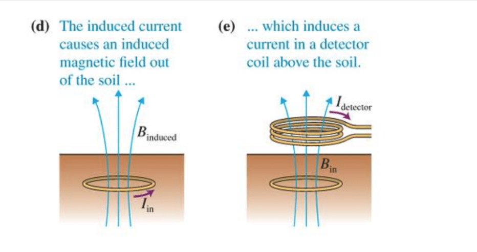
BIO Magnetic induction tomography (MIT) Magnetic induction tomography is an imaging method used in mineral, natural gas, oil, and groundwater exploration, as an archaeological tool; and for medical imaging MIT has also been used to measure topsoil depth in agricultural soils. Topsoil depth is information that many farmers need for instance, corn yield is much higher in soil that has a deep topsoil layer above the underlying, impermeable claypan. Using a trailer attached to a tractor, a farmer can map an
(about 20-acre) field for topsoil depth in about 1 hour.
Figure 21.28 shows how MIT works A time-varying
Why is MIT used to search for mineral deposits (iron, copper, zinc)?
a. The minerals are good conductors of electricity and produce strong induced currents and strong returning magnetic fields.
b. The minerals absorb the incident magnetic field, indicating their presence by a lack of returning signal.
c. The minerals produce their own returning magnetic fields.
d. The minerals attract the incoming magnetic field and reflect it directly above the minerals.
Want to see the full answer?
Check out a sample textbook solution
Chapter 21 Solutions
EBK COLLEGE PHYSICS
Additional Science Textbook Solutions
Brock Biology of Microorganisms (15th Edition)
Microbiology: An Introduction
Anatomy & Physiology (6th Edition)
Human Anatomy & Physiology (2nd Edition)
Campbell Biology: Concepts & Connections (9th Edition)
Genetic Analysis: An Integrated Approach (3rd Edition)


- 20. Two small conducting spheres are placed on top of insulating pads. The 3.7 × 10⁻¹⁰ C sphere is fixed whie the 3.0 × 10⁷ C sphere, initially at rest, is free to move. The mass of each sphere is 0.09 kg. If the spheres are initially 0.10 m apart, how fast will the sphere be moving when they are 1.5 m apart?arrow_forwardpls help on allarrow_forwardpls help on thesearrow_forward
- pls help on all asked questions kindlyarrow_forwardpls help on all asked questions kindlyarrow_forward19. Mount Everest, Earth's highest mountain above sea level, has a peak of 8849 m above sea level. Assume that sea level defines the height of Earth's surface. (re = 6.38 × 10⁶ m, ME = 5.98 × 1024 kg, G = 6.67 × 10 -11 Nm²/kg²) a. Calculate the strength of Earth's gravitational field at a point at the peak of Mount Everest. b. What is the ratio of the strength of Earth's gravitational field at a point 644416m below the surface of the Earth to a point at the top of Mount Everest? C. A tourist watching the sunrise on top of Mount Everest observes a satellite orbiting Earth at an altitude 3580 km above his position. Determine the speed of the satellite.arrow_forward
- pls help on allarrow_forwardpls help on allarrow_forward6. As the distance between two charges decreases, the magnitude of the electric potential energy of the two-charge system: a) Always increases b) Always decreases c) Increases if the charges have the same sign, decreases if they have the opposite signs d) Increases if the charges have the opposite sign, decreases if they have the same sign 7. To analyze the motion of an elastic collision between two charged particles we use conservation of & a) Energy, Velocity b) Momentum, Force c) Mass, Momentum d) Energy, Momentum e) Kinetic Energy, Potential Energyarrow_forward
 College PhysicsPhysicsISBN:9781285737027Author:Raymond A. Serway, Chris VuillePublisher:Cengage Learning
 College PhysicsPhysicsISBN:9781305952300Author:Raymond A. Serway, Chris VuillePublisher:Cengage Learning
 Principles of Physics: A Calculus-Based TextPhysicsISBN:9781133104261Author:Raymond A. Serway, John W. JewettPublisher:Cengage Learning
 College PhysicsPhysicsISBN:9781938168000Author:Paul Peter Urone, Roger HinrichsPublisher:OpenStax College
 Physics for Scientists and Engineers, Technology ...PhysicsISBN:9781305116399Author:Raymond A. Serway, John W. JewettPublisher:Cengage Learning