
A simple sketch of a landscape and label some of the major elements.
Answer to Problem 1BYL
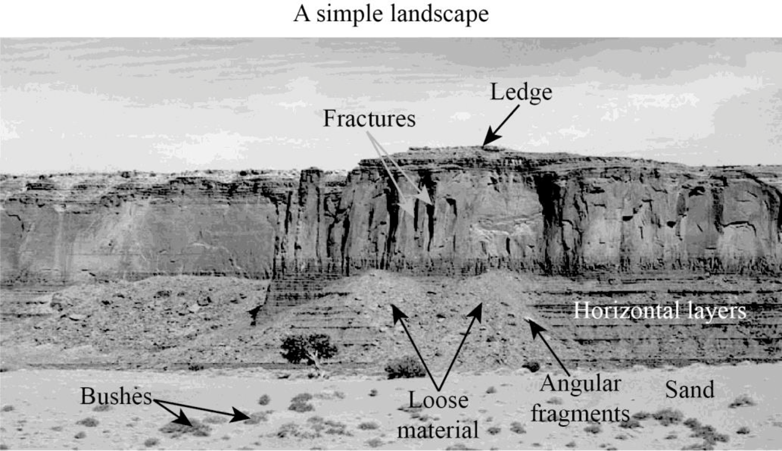
Explanation of Solution
The sketch of a simple landscape is given above, which may be acted upon by geological agents such as wind and water. Various features can be observed evidently on the landscape. First, looking at the cliff, it can be seen that the layers are nearly horizontal.
On further observation, small and large fractures can be seen on the confronting surface of the cliff. The ledges and other rugged parts of the cliff would be made up of resistant rocks. As these rocks are able to withstand weathering due to most geological agents, they remain intact even after the removal of soft materials.
The loose materials observed toward the foot of the cliff may include weathered materials and eroded materials from the top of the cliff. These loose materials contain angular fragments and fine rounded fragments. There is also soil that mostly has sand-sized grains. The grains might have been brought by winds as well. The area is not a vegetated one; only bushes are seen in the region.
Want to see more full solutions like this?
Chapter 2 Solutions
PRINT UPGRADE-EXPLORING GEOLOGY

- 8. The halocline (halo = salt, cline = slope) is a layer of ocean water where there is a rapid change in salin-ity with depth. Label the halocline on Figure 11.9.arrow_forward1. After examining the map and stereogram, draw a line on the map to outline the area illustrated on the stereogram. 2. What evidence on the map indicates that portions of the area are poorly drained? On what part of the map are these features located? 3. Use Figure 9.11 to draw a topographic profile of the X-Y line on Figure 9.10. 4. Is the general topography of the land in Sections 7 and 8 in the northwest portion of the region higher or lower in elevation than the land around the letter A located near the center of the map? Is it more or less hilly? 5. Is the area that coincides with Kettle Moraine State Forest higher or lower in elevation than the land to the northwest and southeast? 6. The feature labeled A on the map is a long ridge composed of till. Is this ridge an esker, an end moraine, or a drumlin?arrow_forward5. Use Figure 9.14 to draw a topographic profile along the X-Y line from Sugar Loaf Mountain to Bear Lake and mark the position of the Lake Fork stream. (Use only index contours.) 6. Describe the shape of Lake Fork Valley, based on your profile. 7. What glacial feature is Lake Fork Valley?arrow_forward
- 7. The streamlined, asymmetrical hills composed of till, labeled B, are what type of feature? 8. Examine the shape of the features labeled B on the map in Figure 9.10. How can these features be used to determine the direction of ice flow in a glaciated area? 9. Using the features labeled B in Figure 9.10 as a guide, draw an arrow on the map to indicate the direction of ice movement that occurred in this region. 10. What is the likely location of the outwash plain on the map? Identify and label the area "outwash plain." (Hint: Refer to Figure 9.7.) 11. Label the area covered by ground moraine. 12. What term is applied to the numerous almost circular depressions designated with the letter C?arrow_forwardRabbit population over time which letter(A,B,or C) shows a growth period for the rabbit populationarrow_forwardActivity 9.5 Depositional Features Associated with Ice Sheets Pgs 159-1611. After examining the map and stereogram, draw a line on the map to outline the area illustrated on the stereogram. 2. What evidence on the map indicates that portions of the area are poorly drained? On what part of the map are these features located? 3. Use Figure 9.11 to draw a topographic profile of the X-Y line on Figure 9.10. 4. Is the general topography of the land in Sections 7 and 8 in the northwest portion of the region higher or lower in elevation than the land around the letter A located near the center of the map? Is it more or less hilly? 5. Is the area that coincides with Kettle Moraine State Forest higher or lower in elevation than the land to the northwest and southeast? 6. The feature labeled A on the map is a long ridge composed of till. Is this ridge an esker, an end moraine, or a drumlin? 7. The streamlined, asymmetrical hills composed of till, labeled B, are what type of feature?The features…arrow_forward
- A prairie has plenty of grass.The soil on the prairie provides all of the following except? A.nutrients that help the grass live and grow B.a place for the roots of the grass to take holdC. Water in pore spaces that the grass can absorb D. Energy that the grass needs to make its foodarrow_forwardtimeters (inches) (11) 25.0 (10) 22.5 (9) 20.0 (8) 17.5 (7) 15.0 (6) 12.5 (5) 10.0 (4) 7.5 (70) 16 (60) 10 (50) 4 (40) 0(32) (30) -18 (3) 5.0 (2) 2.5 (1) 0 25.0 (10) (70) 16 (60) 10 Temperature °C (°F) Temperature °C (°F) — 22.5 (9) (50) 20.0 (8) 17.5 17 15.0 4 (40) 0(32) -1 (30) -7 (6) (20) 12.5 -12 (5) (10) 10.0 -18 (0) (4) (0) -23 7.5 (-10) (3) -23 (-10) -29 5.0 -29 (-20) (2) (-20) -34 2.5 -34 (-30) (-30) -40 0 -40 (-40) J F M A M J JASOND (-40) Month Station: San Francisco, California Lat/long: 37°37' N 122°23' W Avg. Ann. Temp. Total Ann. Precip.: 14°C (57.2°F) 47.5 cm (18.7 in.) Elevation: 5 m (16.4 ft) Population: 777,000 Ann. Temp. Range: 9°C (16.2 F°) Ann. Hr of Sunshine: (a) J F M A M J JASOND Month 2975 Station: Sevilla, Spain Lat/long: 37°22' N 6°00' W Avg. Ann. Temp.: 18°C (64.4°F) Total Ann. Precip.: 55.9 cm (22 in.) (b) Elevation: 13 m (42.6 ft) Population: 683,000 Ann. Temp. Range: 16 C° (28.8 F°) Ann. Hr of Sunshine: 2862 With all graphs, we start with the question,…arrow_forwardI need help with part A, B and Carrow_forward
 Applications and Investigations in Earth Science ...Earth ScienceISBN:9780134746241Author:Edward J. Tarbuck, Frederick K. Lutgens, Dennis G. TasaPublisher:PEARSON
 Exercises for Weather & Climate (9th Edition)Earth ScienceISBN:9780134041360Author:Greg CarbonePublisher:PEARSON
 Environmental ScienceEarth ScienceISBN:9781260153125Author:William P Cunningham Prof., Mary Ann Cunningham ProfessorPublisher:McGraw-Hill Education
 Earth Science (15th Edition)Earth ScienceISBN:9780134543536Author:Edward J. Tarbuck, Frederick K. Lutgens, Dennis G. TasaPublisher:PEARSON
 Environmental Science (MindTap Course List)Earth ScienceISBN:9781337569613Author:G. Tyler Miller, Scott SpoolmanPublisher:Cengage Learning
 Physical GeologyEarth ScienceISBN:9781259916823Author:Plummer, Charles C., CARLSON, Diane H., Hammersley, LisaPublisher:Mcgraw-hill Education,