
Elementary Surveying: An Introduction To Geomatics (15th Edition)
15th Edition
ISBN: 9780134604657
Author: Charles D. Ghilani
Publisher: PEARSON
expand_more
expand_more
format_list_bulleted
Question
Chapter 17, Problem 17.1P
To determine
A list of methods that can be used to display relief on a map.
Expert Solution & Answer
Explanation of Solution
- Contours are the most common method used to show relief or elevation in a topo map. Contour lines are the imaginary lines that join same elevation above the mean sea level. The elevation represents the vertical height from mean sea level. Contour lines to display relief are shown in fig.1.
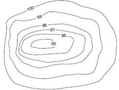
Fig.1
- Form lines are the approximate contours lines which do not shows the accurate elevations. Form lines are used to find the minor details in a topo map. Form lines are represented as dashed lines and it is no labeled with the representative elevations.
- Spot heights are denoted by a black dot followed by a number, which shows the accurate height of the place and the number denotes the height of the place.
- Hachures are the discontinuous parallel lines drawn along the direction of maximum slope, which does not represent the accurate elevation and is mainly used to show large, rocky outcrop areas. These lines are drawn thickly on the high slopes and thinly on the low slope.
- Layer tinting is the method of representing different elevations by means of color. A different color is used to represent each elevation. Layer tinting does not show the accurate height of the specific place.
Want to see more full solutions like this?
Subscribe now to access step-by-step solutions to millions of textbook problems written by subject matter experts!
Students have asked these similar questions
P15.45 WP A stainless steel pipe (Figure P15.45) with an outside diameter of 2.375 in. and a wall thickness of 0.109 in. is subjected to a bending moment M = 50 lb ft and an internal pressure of 180 psi. Determine the absolute maximum shear stress on the outer
surface of the pipe.
M
FIGURE P15.45
M
10.72 What power must the pump supply to the system to pump the oil from the lower reservoir to the upper reservoir at a rate of 0.3 m³/s? Sketch the HGL and the EGL for the system.
p=940 kg/m³
v = 10-5 m²/s
Elevation 100 m
Elevation 112 m
L= 150 m
Oil
Steel pipe
D = 30 cm
Problem 10.72
L
/ 83°
28°
$75°E
M
202°
Q2: The scanning process was
completed from point J to point
N. The direction of the straight
line was LM and the angles of
deviation are shown in the
figure below. Find the direction
of the remaining sides?
N
Chapter 17 Solutions
Elementary Surveying: An Introduction To Geomatics (15th Edition)
Ch. 17 - Prob. 17.1PCh. 17 - Prob. 17.2PCh. 17 - Prob. 17.3PCh. 17 - Prob. 17.4PCh. 17 - Prob. 17.5PCh. 17 - Prob. 17.6PCh. 17 - Prob. 17.7PCh. 17 - Prob. 17.8PCh. 17 - Prob. 17.9PCh. 17 - Prob. 17.10P
Ch. 17 - Prob. 17.11PCh. 17 - Prob. 17.12PCh. 17 - Prob. 17.13PCh. 17 - Prob. 17.14PCh. 17 - Prob. 17.15PCh. 17 - Prob. 17.16PCh. 17 - Prob. 17.17PCh. 17 - Prob. 17.18PCh. 17 - Prob. 17.19PCh. 17 - Prob. 17.20PCh. 17 - Prob. 17.21PCh. 17 - Prob. 17.22PCh. 17 - Prob. 17.23PCh. 17 - Prob. 17.24PCh. 17 - Prob. 17.25PCh. 17 - Prob. 17.26PCh. 17 - Prob. 17.27PCh. 17 - Prob. 17.28PCh. 17 - Prob. 17.29PCh. 17 - Prob. 17.30PCh. 17 - Prob. 17.31PCh. 17 - Prob. 17.32PCh. 17 - Prob. 17.33PCh. 17 - Prob. 17.34PCh. 17 - Prob. 17.35P
Knowledge Booster

Similar questions
- Q3: The scanning process was completed from point F to point G. The direction of the line Fl and the angles of deviation and interior are shown in the figure below. Find the direction of the remaining sides? Azimn = 60° F 52° 52° 72° R= 572.958/D ° T-R tan(A/2) • LC 2R sin (A/2) • E-R (sec(A/2)-1) • M-R (1-cos (A/2)) L= 10 A/D •C=2R sin(2D/2) • d=Dc/10 c' 2R sin (d/2) • Y= √√R2-X2-K • K= R2- K=R-M G H معادلات :مفيدةarrow_forwardPlease write me Background Reviews;arrow_forwardQ1/ The specific gravity of the soil is 1.41 percentage of water content by weight at field capacity and wilting point are 15% and 7% respectively calculate the equivalent moisture content as equivalent depth for 1.2m root zone : 1. at permanent wilting point 2. at field capacity 3. for ready available waterarrow_forward
- Kindy explain the pie chart percentage and give some related study and references about Value of travel time connected to the pie chartarrow_forwardConsider the specifications for an asphaltic concrete mixture and the results of a sieve analysis below. Coarse aggregates: Fine aggregates: Filler: 60% 35% 5% Percent of Weight of Aggregate or Filler Passing Sieve Designation Retained on Sieve Designation Coarse Aggregate Fine Aggregate Mineral Filler 3/4 in. (19 mm) 1/2 in. 6 1/2 in. (12.5 mm) 3/8 in. 15 3/8 in. (9.5 mm) No. 4 50 - No. 4 (4.75 mm) No. 10 20 1 No. 10 (2 mm) No. 40 (0.425 mm) No. 40 9 35 - No. 80 31 40 No. 80 (0.180 mm) No. 200 (0.075 mm) Total No. 200 - 33 - - 25 35 100 100 100 Determine the proportion of different aggregates to obtain the required gradation. Percent of Total Weight of Mixture Passing Sieve Designation Retained on Sieve Designation Coarse Aggregate Fine Aggregate 3/4 in. (19 mm) 1/2 in. (12.5 mm) 3/8 in. (9.5 mm) 1/2 in. 3/8 in. No. 4 No. 4 (4.75 mm) No. 10 No. 10 (2 mm) No. 40 No. 40 (0.425 mm) No. 80 No. 80 (0.180 mm) No. 200 No. 200 (0.075 mm) Total Need Help? Read It Mineral Filler Total 100arrow_forwardResults obtained from laboratory tests on a sample of RC-250 asphalt cement are given. Determine whether the properties of this material meet the Asphalt Institute specifications for this type of material; if not, note the differences. (For each specification, enter the minimum acceptab value in the same units as used in the test results.) • Kinematic viscosity at 140°F (60°C) = 230 centistokes • Flash point (Tagliabue open cup) = 89°F • Distillation test where distillate percent by volume of total distillate to 680°F (360ºC) • To 437°F (225°C) = 27% • To 500°F (260°C) = 69% • To 600°F (316°C) = 72% • Residue from distillation to 680°F (360°C) by volume percentage of sample by difference • Tests on Residue from Distillation: • Ductility at 77°F (25°C) = 92 cm • Absolute viscosity at 140°F (60°C) = 620 poises ⚫ Solubility = 90% Property Kinematic Viscosity = 74% Specification Test Results Were Specifications Met? centistokes 230 centistokes ---Select--- ✓ Flash Point °F 89°F…arrow_forward
- Problem 2 Two machines produce rivets for a factory job. The number of sub-standard rivets per hour by the two machines are random variables, denoted by X1 and X2. The bivariate PMF of X1 and X2, Px,x,(x1,x2), is given in the table below. X2=0 X2=1 X2=2 X2=3 X₁-0 0.07 0.05 0.02 0.01 X₁ =1 0.05 0.16 0.12 0.02 X₁ =2 0.02 0.12 0.17 0.05 X₁ =3 0.01 0.01 0.05 0.07arrow_forwardPlease provide a handwritten solution to the questionarrow_forwardPlease solve the question by hand with a detailed explanation of the steps.arrow_forward
- Please provide a handwritten solution to the questionarrow_forwardplease helparrow_forwardAS Q1/ The specific gravity of the soil is 1.41 percentage of water content by weight at field capacity and wilting point are 15% and 7% respectively calculate the equivalent moisture content as equivalent depth for 1.2m root zone : 1. at permanent wilting point 2. at field capacity 3. for ready available waterarrow_forward
arrow_back_ios
SEE MORE QUESTIONS
arrow_forward_ios
Recommended textbooks for you

 Structural Analysis (10th Edition)Civil EngineeringISBN:9780134610672Author:Russell C. HibbelerPublisher:PEARSON
 Principles of Foundation Engineering (MindTap Cou...Civil EngineeringISBN:9781337705028Author:Braja M. Das, Nagaratnam SivakuganPublisher:Cengage Learning
 Fundamentals of Structural AnalysisCivil EngineeringISBN:9780073398006Author:Kenneth M. Leet Emeritus, Chia-Ming Uang, Joel LanningPublisher:McGraw-Hill Education
 Traffic and Highway EngineeringCivil EngineeringISBN:9781305156241Author:Garber, Nicholas J.Publisher:Cengage Learning
Structural Analysis (10th Edition)
Civil Engineering
ISBN:9780134610672
Author:Russell C. Hibbeler
Publisher:PEARSON
Principles of Foundation Engineering (MindTap Cou...
Civil Engineering
ISBN:9781337705028
Author:Braja M. Das, Nagaratnam Sivakugan
Publisher:Cengage Learning
Fundamentals of Structural Analysis
Civil Engineering
ISBN:9780073398006
Author:Kenneth M. Leet Emeritus, Chia-Ming Uang, Joel Lanning
Publisher:McGraw-Hill Education
Traffic and Highway Engineering
Civil Engineering
ISBN:9781305156241
Author:Garber, Nicholas J.
Publisher:Cengage Learning