The description about the layers of the atmosphere using a sketch.
Answer to Problem 1BYL
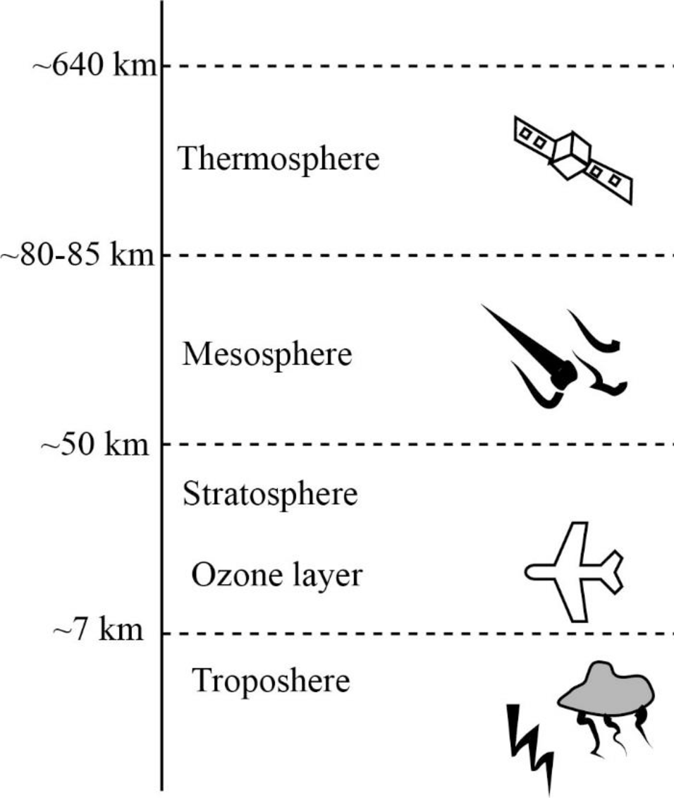
The various layers of atmosphere from the bottom to the top of the Earth’s surface include troposphere, stratosphere, mesosphere, and thermosphere. The swirling motion of clouds, wind, and other manifestations of weather occurs in the troposphere. Commercial jets fly in the stratosphere, burning up of small meteorites take place in the mesosphere, and auroras are formed in the thermosphere.
Explanation of Solution
The atmosphere of the Earth stretches from its surface upward, for greater than 100 km. The atmosphere is not homogeneous in any of its attributes; however it is characterized by different layers that vary in temperature, air pressure, and the amount and composition of gases. The four different layers of the atmosphere are troposphere, stratosphere, mesosphere, and thermosphere.
The lowest layer of the atmosphere that extends from close to the Earth’s surface is the troposphere. The word “tropo” is derived from Greek, which means turning or mixing, on account of the swirling motion of clouds, wind, and other weather manifestations. It is the layer where the interaction of surface inhabitants occurs. It is characterized by the breathable air, clouds, wind, rain, and other weather aspects.
The layer of the atmosphere that exists above the troposphere is known as the stratosphere. It begins at an altitude of about 10 km above the sea level. The term is derived from Latin, which means spreading out, in reference to its layered or non-mixing character. In this layer, the temperature is also layered and it varies from cooler lower altitudes to warmer upper ones. Many commercial jets fly on the lowest part of the stratosphere due to the ability of air to offer less resistance to motion and thereby allow appreciable savings in fuel.
The layer that is situated above the stratosphere and in the middle of the atmosphere is known as the mesosphere. The word “meso” meant middle, in Greek. The mesosphere starts at an altitude of about 50 km at the top of the stratosphere and goes up more than 80 km in altitude. The upper part of the mesosphere is very cold, and it is considered as the coldest place that exists within the Earth system by many scientists. It is the layer at which the burning up of small meteorites take place, which consequently generates the effects known as shooting stars. The radio waves emitted from the Earth bounce off this layer and the overlying layer.
The topmost layer of the atmosphere is known as the thermosphere. The word is derived from the Greek word for heat. When gas particles intercept the energy of Sun, it becomes very hot and would be more than 1500 degree Celsius. In this layer, the interactions of solar energy and energetic gas molecules result in the formation of spectacular auroras.
Want to see more full solutions like this?
Chapter 13 Solutions
Exploring Earth Science

- Why is food waste a growing concern? Describe how some communities are addressing the food waste issue.arrow_forwardDescribe examples of source reductionarrow_forwardIncineration of solid waste is controversial. Do you support solid waste incineration in general?Would you support an incineration facility in your neighborhood?arrow_forward
- Describe why electronic waste is becoming a major problem.arrow_forwardHow does Gateway Community College or Norwalk, CT deal with solid waste? Can solid waste production be limited at your institution or city? How? What barriers exist that might make it difficult to limit solid waste production?arrow_forwardIt is possible to have a high standard of living, as in North America and Western Europe, and not produce large amounts of solid waste. How?arrow_forward
- IM 4G III. > Homework 1 ۲:۱۱ ٢ من ٣ Contouring (EXERCISES) Contour the following data and complete the two profiles .0 3 16 25 2117 12 2 .° 15 O 25 35 5 11 .41 20 18 31 43 16 15 4342 19 21 29 40 .30 13 12 .0 5 29 12 19 2 22 +4 15 2 110 9 D .º B' Turtle Island 0arrow_forward1. What is the contour interval of this map?Contour interval: ____ feet 2. What is the difference in elevation from one index contour to the next?Difference in elevation:____feet 3. On most quadrangles, each section is numbered in red and outlined in red or, occasionally, dashed black lines. Find Section 9, located near the center of the map, and measure its width and length in milesusing the bar scale provided.Sections are _____ miles(s) wide and ____mile(s) long 4. Locate the small intermittent stream (blue dashed line) just below the red number 9 that denotes Section 9. Toward what general direction does the stream flow? Explain how you arrived at your answer.Direction of stream flow: ____Explain: ______ 5. What is the approximate elevation of the point marked with an X in Section 8?Elevation of X _____ feet 6. What is the approximate relief between point X and the surface of Turquoise Lake?Relief:____feet 7. Which of the following phrases best describes the topography of Tennessee…arrow_forward1. The difference in elevation between adjacent contour lines is called the contour interval. Look at the bottom of this map to identify the contour interval.Contour interval: ________ 2. What is the difference in elevation between Points A and B?Difference in elevation: _____ feet 3. Notice that every fifth contour line, called an index contour, is printed as a bold brown line, and the elevation of that line is provided (in feet). List the elevations for each index contour shown on this map._____________ feet, ___________ feet,___________feet 4. Closely spaced contours indicate steep slopes. Which of the four slopes shown with red arrows labeled 1-4 is the steepest? Which is the least steep?Steepest: _______Least steep: _____ 5. One or more roughly circular closed contours indicate a hill. Which of the landforms labeled B-E are hills?Hill landforms: ______ 6. Closed contours with hachures (short lines) that point downslope indicate depressions (basins without outlets). Which of the…arrow_forward
 Applications and Investigations in Earth Science ...Earth ScienceISBN:9780134746241Author:Edward J. Tarbuck, Frederick K. Lutgens, Dennis G. TasaPublisher:PEARSON
 Exercises for Weather & Climate (9th Edition)Earth ScienceISBN:9780134041360Author:Greg CarbonePublisher:PEARSON
 Environmental ScienceEarth ScienceISBN:9781260153125Author:William P Cunningham Prof., Mary Ann Cunningham ProfessorPublisher:McGraw-Hill Education
 Earth Science (15th Edition)Earth ScienceISBN:9780134543536Author:Edward J. Tarbuck, Frederick K. Lutgens, Dennis G. TasaPublisher:PEARSON
 Environmental Science (MindTap Course List)Earth ScienceISBN:9781337569613Author:G. Tyler Miller, Scott SpoolmanPublisher:Cengage Learning
 Physical GeologyEarth ScienceISBN:9781259916823Author:Plummer, Charles C., CARLSON, Diane H., Hammersley, LisaPublisher:Mcgraw-hill Education,