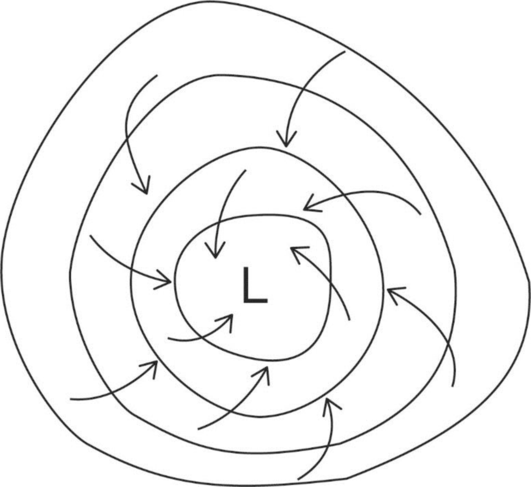
The diagram representing the surface winds around the eye of the Northern Hemisphere hurricane depicted in Figure 13-1.
Answer to Problem 1E
The figure below illustrates the surface winds that can be found around the eye of the Northern Hemisphere hurricane.
Explanation of Solution
Hurricanes can be defined as the rapidly rotating storm systems that form over tropical or subtropical oceans. They are characterized by low-pressure centers, strong winds, and intense convective thunderstorms that lead to the formation of heavy rains. Hurricanes can generate destructive storm surges and tornadoes in addition to strong winds and heavy rains. They are also known as tropical cyclones.
Atmosphere circulates around and inside the low-pressure center of a hurricane. This low- pressure center is known as the eye of the storm. The speeds of the surface wind are light in the eye, attains a maximum speed from the eye, which is approximately 25 kilometers and decreases with distance from the eye wall (an area called the eye wall because of its tall cumulonimbus clouds).
Want to see more full solutions like this?
Chapter 13 Solutions
EBK EXERCISES FOR WEATHER & CLIMATE

- I need help with part a, b, and c.arrow_forwardMake the answer be 2.0 without changing the question. Explain each step and why the answer is 2.0arrow_forward8. The halocline (halo = salt, cline = slope) is a layer of ocean water where there is a rapid change in salin-ity with depth. Label the halocline on Figure 11.9.arrow_forward
- 1. After examining the map and stereogram, draw a line on the map to outline the area illustrated on the stereogram. 2. What evidence on the map indicates that portions of the area are poorly drained? On what part of the map are these features located? 3. Use Figure 9.11 to draw a topographic profile of the X-Y line on Figure 9.10. 4. Is the general topography of the land in Sections 7 and 8 in the northwest portion of the region higher or lower in elevation than the land around the letter A located near the center of the map? Is it more or less hilly? 5. Is the area that coincides with Kettle Moraine State Forest higher or lower in elevation than the land to the northwest and southeast? 6. The feature labeled A on the map is a long ridge composed of till. Is this ridge an esker, an end moraine, or a drumlin?arrow_forward5. Use Figure 9.14 to draw a topographic profile along the X-Y line from Sugar Loaf Mountain to Bear Lake and mark the position of the Lake Fork stream. (Use only index contours.) 6. Describe the shape of Lake Fork Valley, based on your profile. 7. What glacial feature is Lake Fork Valley?arrow_forward7. The streamlined, asymmetrical hills composed of till, labeled B, are what type of feature? 8. Examine the shape of the features labeled B on the map in Figure 9.10. How can these features be used to determine the direction of ice flow in a glaciated area? 9. Using the features labeled B in Figure 9.10 as a guide, draw an arrow on the map to indicate the direction of ice movement that occurred in this region. 10. What is the likely location of the outwash plain on the map? Identify and label the area "outwash plain." (Hint: Refer to Figure 9.7.) 11. Label the area covered by ground moraine. 12. What term is applied to the numerous almost circular depressions designated with the letter C?arrow_forward
- Rabbit population over time which letter(A,B,or C) shows a growth period for the rabbit populationarrow_forwardActivity 9.5 Depositional Features Associated with Ice Sheets Pgs 159-1611. After examining the map and stereogram, draw a line on the map to outline the area illustrated on the stereogram. 2. What evidence on the map indicates that portions of the area are poorly drained? On what part of the map are these features located? 3. Use Figure 9.11 to draw a topographic profile of the X-Y line on Figure 9.10. 4. Is the general topography of the land in Sections 7 and 8 in the northwest portion of the region higher or lower in elevation than the land around the letter A located near the center of the map? Is it more or less hilly? 5. Is the area that coincides with Kettle Moraine State Forest higher or lower in elevation than the land to the northwest and southeast? 6. The feature labeled A on the map is a long ridge composed of till. Is this ridge an esker, an end moraine, or a drumlin? 7. The streamlined, asymmetrical hills composed of till, labeled B, are what type of feature?The features…arrow_forwardA prairie has plenty of grass.The soil on the prairie provides all of the following except? A.nutrients that help the grass live and grow B.a place for the roots of the grass to take holdC. Water in pore spaces that the grass can absorb D. Energy that the grass needs to make its foodarrow_forward
 Applications and Investigations in Earth Science ...Earth ScienceISBN:9780134746241Author:Edward J. Tarbuck, Frederick K. Lutgens, Dennis G. TasaPublisher:PEARSON
 Exercises for Weather & Climate (9th Edition)Earth ScienceISBN:9780134041360Author:Greg CarbonePublisher:PEARSON
 Environmental ScienceEarth ScienceISBN:9781260153125Author:William P Cunningham Prof., Mary Ann Cunningham ProfessorPublisher:McGraw-Hill Education
 Earth Science (15th Edition)Earth ScienceISBN:9780134543536Author:Edward J. Tarbuck, Frederick K. Lutgens, Dennis G. TasaPublisher:PEARSON
 Environmental Science (MindTap Course List)Earth ScienceISBN:9781337569613Author:G. Tyler Miller, Scott SpoolmanPublisher:Cengage Learning
 Physical GeologyEarth ScienceISBN:9781259916823Author:Plummer, Charles C., CARLSON, Diane H., Hammersley, LisaPublisher:Mcgraw-hill Education,