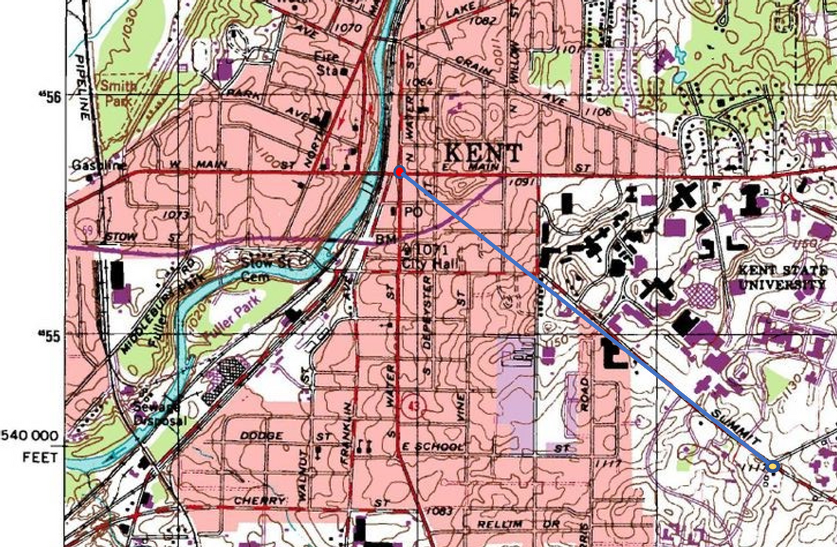
What is the straight line distance from the intersection Main and Water to the intersection of Summit and Rhodes in feet?
What is the straight line distance from the intersection Main and Water to the intersection of Summit and Rhodes in feet?
Applications and Investigations in Earth Science (9th Edition)
9th Edition
ISBN:9780134746241
Author:Edward J. Tarbuck, Frederick K. Lutgens, Dennis G. Tasa
Publisher:Edward J. Tarbuck, Frederick K. Lutgens, Dennis G. Tasa
Chapter1: The Study Of Minerals
Section: Chapter Questions
Problem 1LR
Related questions
Question
What is the straight line distance from the intersection Main and Water to the intersection of Summit and Rhodes in feet?

Transcribed Image Text:1080
PELINE
ROWDER
Co
QTCH
BURNETT
MOTIO
ROAD.
七加
MANTOA
WATER ST
PIPELINE
PPELINE
Plum
"57
GRANT
Háppy Day
Lake
EST
T055
RUYAHOGA
Gaşoine
ower
LAKE
Sta
VSmith
$56
rive in
Theater
KENT
iSand and Graven
1/601
BreaKhec
Meadowview
69
Golf Course
082
LISHIAINO
55
9601
Wler Park
050
Cree
000
FEET
30000
RHODES
FOOHDS 3
Pumping
CHERRY:
OTower
ugneisgng
Ftration
Qwer
1056
$54
690
ROAD
T.3 N.
073
0.
CITY
1065(x
1050
T. 2 N.
261
Iomer,
PELINE
553
M
41°07'30" +
81 22'30"
KENT BOC
STATE NATURE PRESERVE
120
*71 2 320 000 FEET
69,
20'
73
(SUFFIELD) 74
"M 6.
R. 8 w:75
17'30
Produced by the United States Gęological Survey
Topography compiled 1952. Planimetry derived from imagery taken
3S III 99
SCALE 1:24 000
MS III 994
1982. Photoinspected using imagery dated 1994; no major culture
or drainage changes observed. Survey control current as of 1960
Boundaries, other than corporate, revised 1997
North American Datum of 1927 (NAD 27). Projection and
10 000-foot ticks: Ohio coordinate system, north zone
(Lambert conformal conic)
1000-meter Universal Transverse Mercator grid, zone 17
1 MILE
RON EAST)
0001
0001
000
200
000
2009
N9
1 KILOMETER
142 MILS
CONTOUR INTERVAL 10 FEET
NATIONAL GEODETIC VERTICAL DATUM OF 1929
TO CONVERT FROM FEET TO METERS, MULTIPLY BY 0.3048
012'
4 MILS
Expert Solution
Step 1
Step 1: Locate the two points of intersection and draw a straight line between them

In the map above:
- Red dot with a black outline is the point of intersection between Main and Water.
- Yellow dot with a black outline is the point of intersection between Summit and Rhodes.
- Blue line denoted the straight-line distance between the two points.
Step by step
Solved in 2 steps with 1 images

Recommended textbooks for you

Applications and Investigations in Earth Science …
Earth Science
ISBN:
9780134746241
Author:
Edward J. Tarbuck, Frederick K. Lutgens, Dennis G. Tasa
Publisher:
PEARSON

Exercises for Weather & Climate (9th Edition)
Earth Science
ISBN:
9780134041360
Author:
Greg Carbone
Publisher:
PEARSON

Environmental Science
Earth Science
ISBN:
9781260153125
Author:
William P Cunningham Prof., Mary Ann Cunningham Professor
Publisher:
McGraw-Hill Education

Applications and Investigations in Earth Science …
Earth Science
ISBN:
9780134746241
Author:
Edward J. Tarbuck, Frederick K. Lutgens, Dennis G. Tasa
Publisher:
PEARSON

Exercises for Weather & Climate (9th Edition)
Earth Science
ISBN:
9780134041360
Author:
Greg Carbone
Publisher:
PEARSON

Environmental Science
Earth Science
ISBN:
9781260153125
Author:
William P Cunningham Prof., Mary Ann Cunningham Professor
Publisher:
McGraw-Hill Education

Earth Science (15th Edition)
Earth Science
ISBN:
9780134543536
Author:
Edward J. Tarbuck, Frederick K. Lutgens, Dennis G. Tasa
Publisher:
PEARSON

Environmental Science (MindTap Course List)
Earth Science
ISBN:
9781337569613
Author:
G. Tyler Miller, Scott Spoolman
Publisher:
Cengage Learning

Physical Geology
Earth Science
ISBN:
9781259916823
Author:
Plummer, Charles C., CARLSON, Diane H., Hammersley, Lisa
Publisher:
Mcgraw-hill Education,