Researchers claim that the surface temperature of the world's oceans mainly changes with changing latitude. The warmest waters are near the equator and the coldest waters are in the Arctic and Antarctic regions. To examine this claim, an experiment has been designed and the following data has been collected from coastal areas in the southern hemisphere for 5 consecutive years in the middle of November. The recorded temperatures are all averages across the 5 years of data.
Researchers claim that the surface temperature of the world's oceans mainly changes with changing latitude. The warmest waters are near the equator and the coldest waters are in the Arctic and Antarctic regions. To examine this claim, an experiment has been designed and the following data has been collected from coastal areas in the southern hemisphere for 5 consecutive years in the middle of November. The recorded temperatures are all averages across the 5 years of data.
MATLAB: An Introduction with Applications
6th Edition
ISBN:9781119256830
Author:Amos Gilat
Publisher:Amos Gilat
Chapter1: Starting With Matlab
Section: Chapter Questions
Problem 1P
Related questions
Question

Transcribed Image Text:Researchers claim that the surface temperature of the world's oceans mainly changes with
changing latitude. The warmest waters are near the equator and the coldest waters are in the
Arctic and Antarctic regions. To examine this claim, an experiment has been designed and the
following data has been collected from coastal areas in the southern hemisphere for 5
consecutive years in the middle of November. The recorded temperatures are all averages
across the 5 years of data.
Coastal ocean
Surface
Temperature
Latitude
44
42
40
38
36
34
32
30
28
26
24
22
20
18
16
14
12
10
8
6
14.1
15.2
16.2
17.5
18
21
22.1
23.8
24.5
24.2
24.4
26
26.9
28.2
28.5
28.8
29.8
29.8
31.2
32.5
.
Coastal Air
Temperature
●
16
17
15
15
18.5
22
24.5
24
25
26.5
30
31.6
30.4
33.5
Note: Temperature.xlsx is also attached.
a) Convert the latitude numerical variable to a categorical variable
with 4 levels (very low, low, moderate, high), using a statistical software package.
Find the overall mean, group means, and group standard deviations
using the statistical package.
33
32
32
33.5
34
30
Conduct an ANOVA test to find the possible impact of latitude on
coastal ocean surface temperature.
Write the assumptions of the model, write out the model in cell
means/classical/regression form,
conduct the analysis in a statistical software package, run the
Tukey HSD test if needed,
and state a conclusion based on the output.
b) Plot a scatterplot with coastal ocean surface temperature
(horizontal axis) and costal air
temperature (vertical axis). Interpret the output.
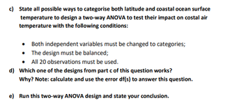
c) State all possible ways to categorise both latitude and coastal ocean surface
temperature to design a two-way ANOVA to test their impact on costal air
temperature with the following conditions:
Both independent variables must be changed to categories;
The design must be balanced;
All 20 observations must be used.
d) Which one of the designs from part c of this question works?
Why? Note: calculate and use the error df(s) to answer this question.
e) Run this two-way ANOVA design and state your conclusion.
Expert Solution
This question has been solved!
Explore an expertly crafted, step-by-step solution for a thorough understanding of key concepts.
This is a popular solution!
Trending now
This is a popular solution!
Step by step
Solved in 3 steps with 5 images

Follow-up Questions
Read through expert solutions to related follow-up questions below.
Follow-up Question

Transcribed Image Text:c) State all possible ways to categorise both latitude and coastal ocean surface
temperature to design a two-way ANOVA to test their impact on costal air
temperature with the following conditions:
• Both independent variables must be changed to categories;
• The design must be balanced;
All 20 observations must be used.
d) Which one of the designs from part c of this question works?
Why? Note: calculate and use the error df(s) to answer this question.
e) Run this two-way ANOVA design and state your conclusion.
Solution
Follow-up Question

Transcribed Image Text:c) State all possible ways to categorise both latitude and coastal ocean surface
temperature to design a two-way ANOVA to test their impact on costal air
temperature with the following conditions:
. Both independent variables must be changed to categories;
• The design must be balanced;
• All 20 observations must be used.
Solution
Recommended textbooks for you

MATLAB: An Introduction with Applications
Statistics
ISBN:
9781119256830
Author:
Amos Gilat
Publisher:
John Wiley & Sons Inc

Probability and Statistics for Engineering and th…
Statistics
ISBN:
9781305251809
Author:
Jay L. Devore
Publisher:
Cengage Learning

Statistics for The Behavioral Sciences (MindTap C…
Statistics
ISBN:
9781305504912
Author:
Frederick J Gravetter, Larry B. Wallnau
Publisher:
Cengage Learning

MATLAB: An Introduction with Applications
Statistics
ISBN:
9781119256830
Author:
Amos Gilat
Publisher:
John Wiley & Sons Inc

Probability and Statistics for Engineering and th…
Statistics
ISBN:
9781305251809
Author:
Jay L. Devore
Publisher:
Cengage Learning

Statistics for The Behavioral Sciences (MindTap C…
Statistics
ISBN:
9781305504912
Author:
Frederick J Gravetter, Larry B. Wallnau
Publisher:
Cengage Learning

Elementary Statistics: Picturing the World (7th E…
Statistics
ISBN:
9780134683416
Author:
Ron Larson, Betsy Farber
Publisher:
PEARSON

The Basic Practice of Statistics
Statistics
ISBN:
9781319042578
Author:
David S. Moore, William I. Notz, Michael A. Fligner
Publisher:
W. H. Freeman

Introduction to the Practice of Statistics
Statistics
ISBN:
9781319013387
Author:
David S. Moore, George P. McCabe, Bruce A. Craig
Publisher:
W. H. Freeman