The Earth–Sun orientation will change throughout the year as Earth revolves around the Sun. Using Figures 2-3 and 2-4 as models, sketch two similar diagrams for each date given to the right and below. First draw Earth’s axis and equator on the globe. Then, on the “sunny side” of the globe, draw a short line representing a flat surface at 66.5° N, 30° N, 0°, and 23.5° S, a stick figure at each site with the Sun’s rays striking the flat surface at the feet of the stick figure. On the profile view, draw the Sun’s rays striking the flat surface transcribing the angles that you drew on the globe.
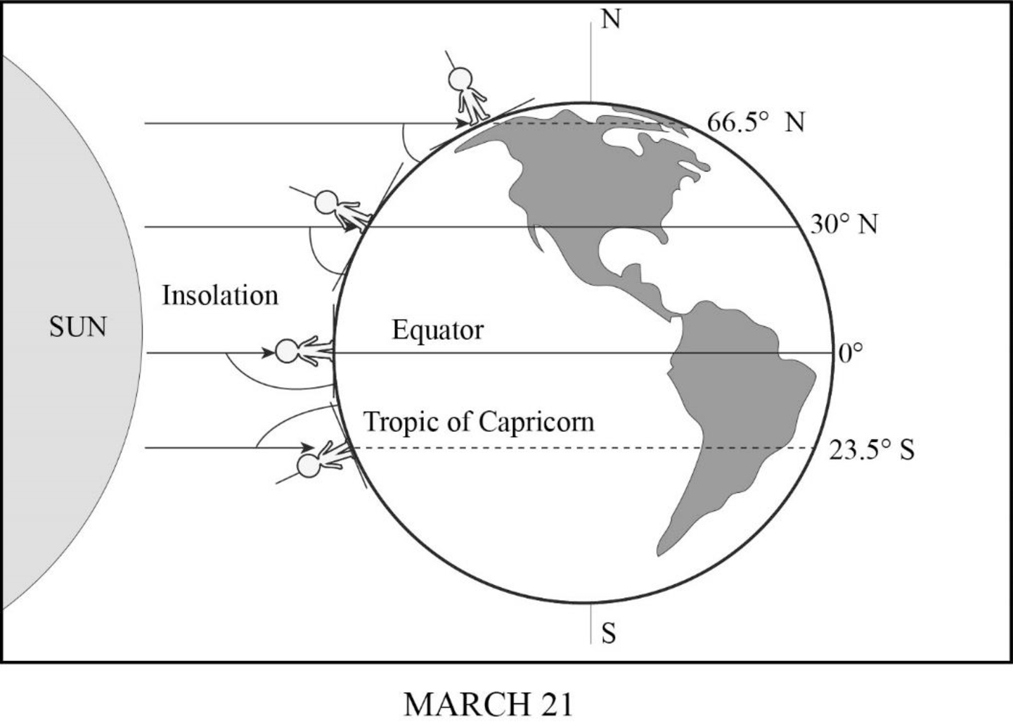
Sun’s rays striking Earth on March 21.
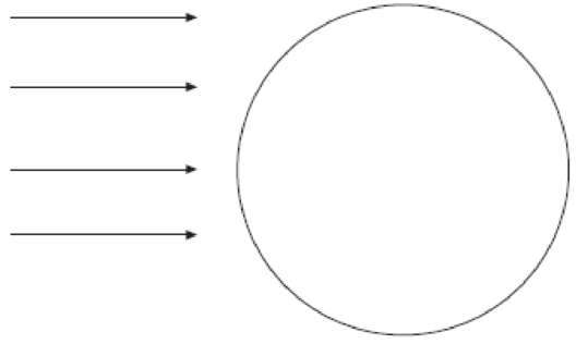
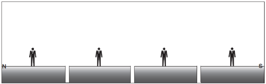
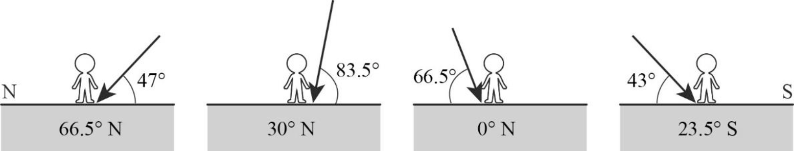
Profile view at Earth’s surface: solar noon on March 21.
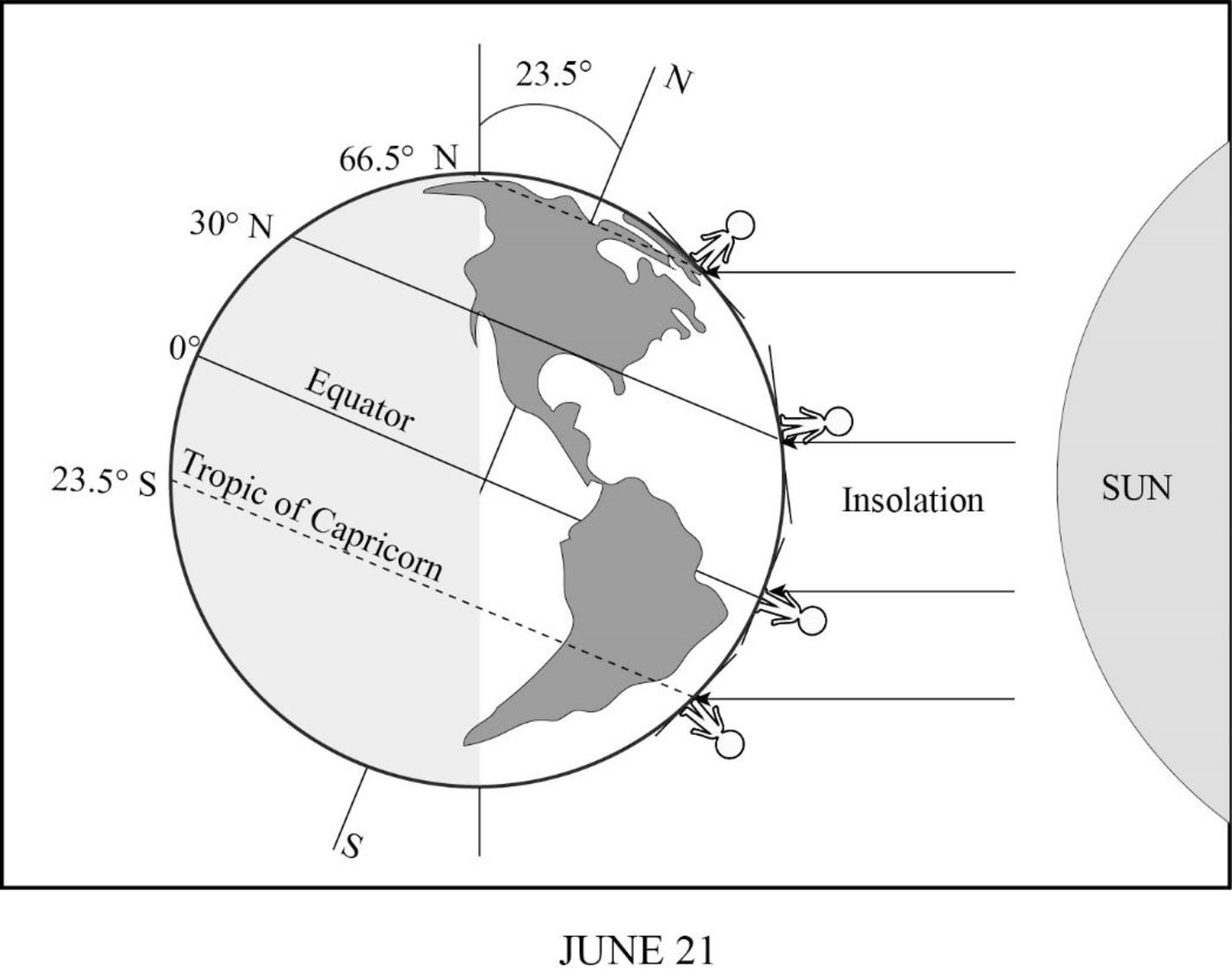
Sun’s rays striking Earth on June 21.
Profile view at Earth’s surface: solar noon on June 21.
Sketch representation of the incidence of the Sun’s rays on the images given in the question, on March 21 and June 21.
Answer to Problem 1E
On March 21, which is the time of vernal equinox on the Northern Hemisphere and autumn equinox in the Southern Hemisphere, there will be direct incidence of sunlight on the equator as well as on the other latitudes north and south of the equator. The figures given below represent the angle of incidence of insolation on various latitudes.
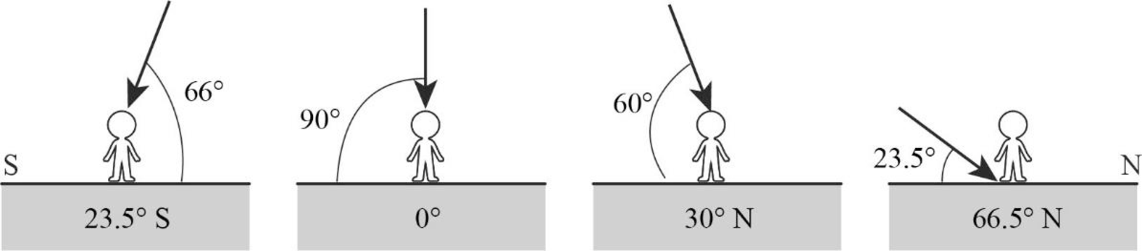
On June 21, which is the time of Summer Solstice in the Northern Hemisphere, the Sun will be more direct over the Northern Hemisphere, indicating the beginning of Summer season. The North Pole will be inclined at an angle of
Explanation of Solution
On March 21, the Earth exhibits an equinox time. It is generally known as vernal equinox in the Northern hemisphere, while in the Southern Hemisphere, it is known as autumn equinox. During equinox, neither of the poles would be specifically inclined toward the Sun nor would any of the poles be receiving more insolation. Instead, both the hemispheres will experience equal duration of day and night. The insolation might fall on the Earth vertically, which means the equator along with latitudes above and below it receives vertical rays of the Sun.
June 21 is referred to as the June Solstice or Summer Solstice in the Northern Hemisphere. Solstice is the time during which one of the hemispheres will be facing the Sun more directly. During June Solstice, the Earth’s rotation axis over the North Pole is most directed or inclined (by nearly
Want to see more full solutions like this?
Chapter 2 Solutions
Exercises for Weather & Climate (9th Edition)
Additional Science Textbook Solutions
Campbell Essential Biology (7th Edition)
Microbiology with Diseases by Body System (5th Edition)
Human Physiology: An Integrated Approach (8th Edition)
Introductory Chemistry (6th Edition)
Chemistry: An Introduction to General, Organic, and Biological Chemistry (13th Edition)
Campbell Biology (11th Edition)

- the questions often be used to determine the age ofmetamorphic rocks.Questions1. List the relative age of the rocks in Figure 2with oldest first.2. What stratigraphic principles did you use todetermine the age of the rocks in Figure 2?3. If layer A is 418 Ma and layer B is 388 Ma, what geological Period(s) are layers C and D likely to befrom?4. Layer C contains fish fossils.a. Circle the rock type for layer C. Igneous Sedimentary Metamorphicb. Explain how the fish fossils could be used to determine the date of rocks elsewhere.c. Outline possible reasons why the other layers do NOT contain fossilarrow_forwardDiscussion Question: Atmospheric Energy and Global Temperatures Albedo values (% reflected) Fresh snow 80%-95% Grass 25-30% Forests 10%-20% Crops, grasslands 10%-25% Asphat (black top 5%-10% Cancel 17-27 Moon Water bodies 10%-60% (varies with Sun altitude) Earth's albedo (average) 31% Dark roof 8%-18% Light roof 35%-50% Brick, stone 20%-40%arrow_forwardOutline of topic: Increased urbanization together with climate changes forces cities to find solutions for their simultaneous water shortage and flooding problems. The preservation of water resources needs sustainable urban water management strategies that combine ecological health maintenance with these priorities. This study investigates combined strategies that involve rainwater collection together with wastewater treatment and the deployment of green infrastructure consisting of urban wetlands alongside permeable pavements. The research aims to discover multi-purpose solutions that decrease flood dangers together with water shortages while maintaining ecological health for long-term urban water management success. The research investigates ways in which novel solutions assist cities to create watertight urban areas capable of handling environmental pressures from global warming and population expansion. Research questions: What are the economic, environmental, and social benefits…arrow_forward
- Title: Implementing low impact development: Sustainable water management solutions for urban areas Research questions: What are the economic, environmental, and social benefits of integrating wastewater recycling systems into urban water management practices? What methods can cities employ to resolve water supply needs with natural resource defense while achieving long-term water resource sustainability? Please answer all questions in the pictures in detailarrow_forwardMap 2. Parts 1 through 7. I Dont understand how to answer these questions on the map. Please help me step by step.arrow_forwardI desperately need help understanding and doing assignment step by step please. Parts 1 through 7 for the one question.arrow_forward
- Map 2 parts 1 through 7. I need help with the steps and to understand how to complete the assignment. 1) On the map, draw a single red pencil line that represents the kern river recharge axis. 2) on the map draw 3 to 5 additional red lines in closing what appear to be other smaller recharge areas, possibly the locations of isolated individual recharge points. 3) on the map, draw for useful spaced blue pencil lines that represent groundwater flow from the kern river recharge access into the basin north of the river. 5) on the map, draw any necessary, additional blue pencil lines to fully illustrate groundwater flow from the current river recharge axis. 6) what is the groundwater gradient immediately north of the main recharge area? 7) what is the groundwater gradient immediately south of the main recharge area?arrow_forwardPlease answer all questions and all part questions in detail and show all workarrow_forwardPlease answer all questions in detail and show all workarrow_forward
- Please show all workarrow_forwardplastic bottles are better than glass bottles due to their cost-effectiveness, practicality in transportation and use, and advancements in sustainable production. How is this true?arrow_forwardShale and siltstone volcanic ash. erosjon surfaçe limestone sandstone erosion surface pegmatite granite slate dike BUY Aparrow_forward
 Applications and Investigations in Earth Science ...Earth ScienceISBN:9780134746241Author:Edward J. Tarbuck, Frederick K. Lutgens, Dennis G. TasaPublisher:PEARSON
 Exercises for Weather & Climate (9th Edition)Earth ScienceISBN:9780134041360Author:Greg CarbonePublisher:PEARSON
 Environmental ScienceEarth ScienceISBN:9781260153125Author:William P Cunningham Prof., Mary Ann Cunningham ProfessorPublisher:McGraw-Hill Education
 Earth Science (15th Edition)Earth ScienceISBN:9780134543536Author:Edward J. Tarbuck, Frederick K. Lutgens, Dennis G. TasaPublisher:PEARSON
 Environmental Science (MindTap Course List)Earth ScienceISBN:9781337569613Author:G. Tyler Miller, Scott SpoolmanPublisher:Cengage Learning
 Physical GeologyEarth ScienceISBN:9781259916823Author:Plummer, Charles C., CARLSON, Diane H., Hammersley, LisaPublisher:Mcgraw-hill Education,